array:2 [
"RF Cache Key: 093fb895aaf35324be85d9206d1af47c940ab16f3bf233008906b406ce706f88" => array:1 [
"RF Cached Response" => Realtyna\MlsOnTheFly\Components\CloudPost\SubComponents\RFClient\SDK\RF\RFResponse {#14883
+items: array:10 [
0 => Realtyna\MlsOnTheFly\Components\CloudPost\SubComponents\RFClient\SDK\RF\Entities\RFProperty {#14401
+post_id: ? mixed
+post_author: ? mixed
+"ListingKey": "X12343948"
+"ListingId": "X12343948"
+"PropertyType": "Residential"
+"PropertySubType": "Vacant Land"
+"StandardStatus": "Active"
+"ModificationTimestamp": "2025-09-21T08:05:28Z"
+"RFModificationTimestamp": "2025-09-21T08:08:46Z"
+"ListPrice": 85000.0
+"BathroomsTotalInteger": 0
+"BathroomsHalf": 0
+"BedroomsTotal": 0
+"LotSizeArea": 1.079
+"LivingArea": 0
+"BuildingAreaTotal": 0
+"City": "Algonquin Highlands"
+"PostalCode": "K0M 1S0"
+"UnparsedAddress": "0 Barry Line Road, Algonquin Highlands, ON K0M 1S0"
+"Coordinates": array:2 [
0 => -78.8255515
1 => 45.2946735
]
+"Latitude": 45.2946735
+"Longitude": -78.8255515
+"YearBuilt": 0
+"InternetAddressDisplayYN": true
+"FeedTypes": "IDX"
+"ListOfficeName": "RE/MAX Professionals North"
+"OriginatingSystemName": "TRREB"
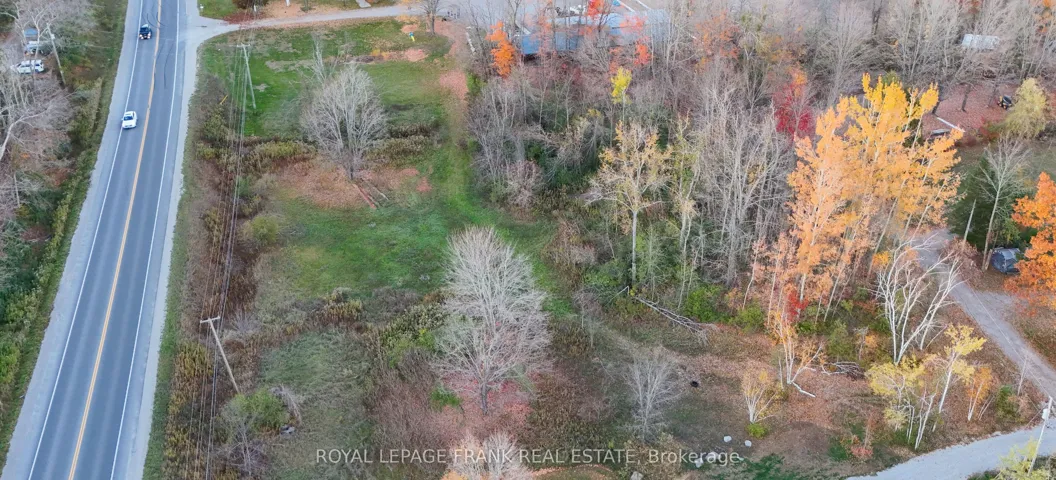
+"PublicRemarks": "Discover this level, just-over-1-acre building lot perfectly positioned at the corner of Barry Line Road and Cameron Lane. Barry Line Road is maintained year-round by the municipality, youll enjoy easy access in every season. Located only minutes from West Guilford, where youll find a convenient general store complete with an LCBO outlet, public beach and community center. Ten minutes from the Village of Haliburton, this property offers the ideal balance of rural tranquility and nearby conveniences. The sandy soil makes excavation a breeze, setting the stage for your dream home or cottage. A hydro easement runs through the property."
+"CityRegion": "Stanhope"
+"CoListOfficeName": "RE/MAX Professionals North"
+"CoListOfficePhone": "705-457-1011"
+"CountyOrParish": "Haliburton"
+"CreationDate": "2025-08-14T14:27:18.350701+00:00"
+"CrossStreet": "Highway 118"
+"DirectionFaces": "North"
+"Directions": "Highway 118 to Stanhope Airport Road to Barry Line Road"
+"Exclusions": "n/a"
+"ExpirationDate": "2025-12-15"
+"Inclusions": "n/a"
+"RFTransactionType": "For Sale"
+"InternetEntireListingDisplayYN": true
+"ListAOR": "One Point Association of REALTORS"
+"ListingContractDate": "2025-08-13"
+"LotSizeSource": "Geo Warehouse"
+"MainOfficeKey": "549100"
+"MajorChangeTimestamp": "2025-08-14T14:04:26Z"
+"MlsStatus": "New"
+"OccupantType": "Vacant"
+"OriginalEntryTimestamp": "2025-08-14T14:04:26Z"
+"OriginalListPrice": 85000.0
+"OriginatingSystemID": "A00001796"
+"OriginatingSystemKey": "Draft2843334"
+"ParcelNumber": "391320140"
+"PhotosChangeTimestamp": "2025-08-14T14:04:26Z"
+"ShowingRequirements": array:2 [
0 => "Go Direct"
1 => "Showing System"
]
+"SignOnPropertyYN": true
+"SourceSystemID": "A00001796"
+"SourceSystemName": "Toronto Regional Real Estate Board"
+"StateOrProvince": "ON"
+"StreetName": "Barry Line"
+"StreetNumber": "0"
+"StreetSuffix": "Road"
+"TaxAnnualAmount": "159.28"
+"TaxLegalDescription": "PT LT 30 CON 7 STANHOPE PT 2 & 3 19R7488; S/T H259356; S/T BENEFICIARIES INTEREST IN H257801; S/T RIGHT IN H144981; ALGONQUIN HIGHLANDS"
+"TaxYear": "2025"
+"TransactionBrokerCompensation": "2.5"
+"TransactionType": "For Sale"
+"Zoning": "RR"
+"DDFYN": true
+"GasYNA": "No"
+"CableYNA": "No"
+"LotShape": "Irregular"
+"LotWidth": 132.06
+"SewerYNA": "No"
+"WaterYNA": "No"
+"@odata.id": "https://api.realtyfeed.com/reso/odata/Property('X12343948')"
+"SurveyType": "Available"
+"Waterfront": array:1 [
0 => "None"
]
+"ElectricYNA": "Available"
+"HoldoverDays": 90
+"TelephoneYNA": "Available"
+"provider_name": "TRREB"
+"ContractStatus": "Available"
+"HSTApplication": array:1 [
0 => "Included In"
]
+"PossessionDate": "2025-09-30"
+"PossessionType": "Immediate"
+"PriorMlsStatus": "Draft"
+"LotSizeAreaUnits": "Acres"
+"LotSizeRangeAcres": ".50-1.99"
+"SpecialDesignation": array:1 [
0 => "Unknown"
]
+"MediaChangeTimestamp": "2025-08-14T14:04:26Z"
+"SystemModificationTimestamp": "2025-09-21T08:05:28.919958Z"
+"Media": array:11 [
0 => array:26 [ …26]
1 => array:26 [ …26]
2 => array:26 [ …26]
3 => array:26 [ …26]
4 => array:26 [ …26]
5 => array:26 [ …26]
6 => array:26 [ …26]
7 => array:26 [ …26]
8 => array:26 [ …26]
9 => array:26 [ …26]
10 => array:26 [ …26]
]
}
1 => Realtyna\MlsOnTheFly\Components\CloudPost\SubComponents\RFClient\SDK\RF\Entities\RFProperty {#14664
+post_id: ? mixed
+post_author: ? mixed
+"ListingKey": "X12343881"
+"ListingId": "X12343881"
+"PropertyType": "Residential"
+"PropertySubType": "Vacant Land"
+"StandardStatus": "Active"
+"ModificationTimestamp": "2025-09-21T08:03:46Z"
+"RFModificationTimestamp": "2025-09-21T08:08:46Z"
+"ListPrice": 299900.0
+"BathroomsTotalInteger": 0
+"BathroomsHalf": 0
+"BedroomsTotal": 0
+"LotSizeArea": 15.0
+"LivingArea": 0
+"BuildingAreaTotal": 0
+"City": "Stirling-rawdon"
+"PostalCode": "K0K 3E0"
+"UnparsedAddress": "878 Harold Road, Stirling-rawdon, ON K0K 3E0"
+"Coordinates": array:2 [
0 => -77.6483318
1 => 44.3656931
]
+"Latitude": 44.3656931
+"Longitude": -77.6483318
+"YearBuilt": 0
+"InternetAddressDisplayYN": true
+"FeedTypes": "IDX"
+"ListOfficeName": "ROYAL LEPAGE PROALLIANCE REALTY"
+"OriginatingSystemName": "TRREB"
+"PublicRemarks": "Discover a rare blend of beauty, privacy, and natural wonder on this 15-acre property tucked away on quiet Harold Road, just north of Stirling. Surrounded by open farm fields and forest this setting offers the kind of peace and tranquility that feels untouched by time. Wake up to breathtaking sunrises, unwind with glowing sunsets over rolling hills, and watch storms dance across the skyline. At night, the unspoiled darkness reveals a canopy of stars, perfect for stargazing. This is a place where nature sets the pace, and its beauty can't truly be scripted or captured, only experienced. A gravel driveway runs alongside the property, leading to a variety of outbuildings and possibilities for your vision. The 10' x 16' wired and insulated potting shed, with a wood-stove offers space for year-round gardening projects. A matching 10' x 16' storage shed houses solar equipment and an additional wood-stove. You'll also find an outhouse with a compostable toilet, a chicken coop, a goat barn with fencing, and established vegetable and herb gardens. The land has been organically maintained since 1979, with newly planted pine, hardwood, and fruit trees/bushes including apple, raspberry, mulberry, and elderberry. Winding trails, some cleared, some carved naturally by local wildlife like deer and coyotes, lead to multiple quiet sitting areas, each with its own unique view of the landscape. The original homestead still stands, now serving as storage, offering a nostalgic reminder of the property's history. For those who value privacy, natural beauty, and a connection to the land, this property offers a lifestyle that can't be replicated. Whether you dream of homesteading, building your ideal retreat, or simply living among nature, the possibilities here are as open as the horizon."
+"CityRegion": "Rawdon Ward"
+"CoListOfficeName": "ROYAL LEPAGE PROALLIANCE REALTY"
+"CoListOfficePhone": "613-966-6060"
+"CountyOrParish": "Hastings"
+"CreationDate": "2025-08-14T14:13:33.026993+00:00"
+"CrossStreet": "Harold Road and Highway 14"
+"DirectionFaces": "North"
+"Directions": "Highway 14 North from Stirling to Harold Road. West on Harold Road to 878 - Sign on property"
+"Disclosures": array:1 [
0 => "Unknown"
]
+"Exclusions": "Gazebo, Adirondack Chairs, Personal Belongings, All Lawn + Garden ornaments + Equipment, Firewood, Rainbarrels, Seacan, Welltiles on Driveway"
+"ExpirationDate": "2025-11-30"
+"Inclusions": "Solar System + Batteries, All Outbuildings, Burn Barrel"
+"RFTransactionType": "For Sale"
+"InternetEntireListingDisplayYN": true
+"ListAOR": "Central Lakes Association of REALTORS"
+"ListingContractDate": "2025-08-14"
+"LotSizeSource": "Geo Warehouse"
+"MainOfficeKey": "179000"
+"MajorChangeTimestamp": "2025-08-14T13:51:22Z"
+"MlsStatus": "New"
+"OccupantType": "Owner"
+"OriginalEntryTimestamp": "2025-08-14T13:51:22Z"
+"OriginalListPrice": 299900.0
+"OriginatingSystemID": "A00001796"
+"OriginatingSystemKey": "Draft2842880"
+"OtherStructures": array:3 [
0 => "Other"
1 => "Out Buildings"
2 => "Shed"
]
+"ParcelNumber": "403420188"
+"ParkingFeatures": array:1 [
0 => "Private"
]
+"ParkingTotal": "10.0"
+"PhotosChangeTimestamp": "2025-08-14T13:51:22Z"
+"PoolFeatures": array:1 [
0 => "None"
]
+"Sewer": array:1 [
0 => "None"
]
+"ShowingRequirements": array:2 [
0 => "Showing System"
1 => "List Salesperson"
]
+"SignOnPropertyYN": true
+"SourceSystemID": "A00001796"
+"SourceSystemName": "Toronto Regional Real Estate Board"
+"StateOrProvince": "ON"
+"StreetName": "Harold"
+"StreetNumber": "878"
+"StreetSuffix": "Road"
+"TaxAnnualAmount": "893.43"
+"TaxLegalDescription": "PART LOT 19, CONCESSION 8 RAWDON, PART 1 PLAN 21R25393 TOWNSHIP OF STIRLING RAWDON"
+"TaxYear": "2025"
+"Topography": array:3 [
0 => "Flat"
1 => "Rolling"
2 => "Wooded/Treed"
]
+"TransactionBrokerCompensation": "2.5% + HST"
+"TransactionType": "For Sale"
+"View": array:4 [
0 => "Hills"
1 => "Pasture"
2 => "Trees/Woods"
3 => "Valley"
]
+"WaterSource": array:1 [
0 => "None"
]
+"Zoning": "MA"
+"DDFYN": true
+"Water": "None"
+"GasYNA": "No"
+"Sewage": array:1 [
0 => "Privy"
]
+"CableYNA": "Available"
+"LotDepth": 1996.43
+"LotShape": "Irregular"
+"LotWidth": 330.0
+"SewerYNA": "No"
+"WaterYNA": "No"
+"@odata.id": "https://api.realtyfeed.com/reso/odata/Property('X12343881')"
+"GarageType": "None"
+"RollNumber": "122011902010702"
+"SurveyType": "Boundary Only"
+"Waterfront": array:1 [
0 => "None"
]
+"ElectricYNA": "Available"
+"HoldoverDays": 90
+"TelephoneYNA": "No"
+"ParkingSpaces": 10
+"provider_name": "TRREB"
+"ContractStatus": "Available"
+"HSTApplication": array:1 [
0 => "Included In"
]
+"PossessionType": "Flexible"
+"PriorMlsStatus": "Draft"
+"RuralUtilities": array:8 [
0 => "Cable Available"
1 => "Cell Services"
2 => "Electricity On Road"
3 => "Electricity To Lot Line"
4 => "Garbage Pickup"
5 => "Internet High Speed"
6 => "Off Grid"
7 => "Recycling Pickup"
]
+"AccessToProperty": array:1 [
0 => "Year Round Municipal Road"
]
+"AlternativePower": array:1 [
0 => "Solar Power"
]
+"LotSizeAreaUnits": "Acres"
+"PropertyFeatures": array:4 [
0 => "Part Cleared"
1 => "Rolling"
2 => "School Bus Route"
3 => "Wooded/Treed"
]
+"LotSizeRangeAcres": "10-24.99"
+"PossessionDetails": "FLEXIBLE"
+"SpecialDesignation": array:1 [
0 => "Unknown"
]
+"MediaChangeTimestamp": "2025-08-14T13:51:22Z"
+"SystemModificationTimestamp": "2025-09-21T08:03:46.374905Z"
+"Media": array:36 [
0 => array:26 [ …26]
1 => array:26 [ …26]
2 => array:26 [ …26]
3 => array:26 [ …26]
4 => array:26 [ …26]
5 => array:26 [ …26]
6 => array:26 [ …26]
7 => array:26 [ …26]
8 => array:26 [ …26]
9 => array:26 [ …26]
10 => array:26 [ …26]
11 => array:26 [ …26]
12 => array:26 [ …26]
13 => array:26 [ …26]
14 => array:26 [ …26]
15 => array:26 [ …26]
16 => array:26 [ …26]
17 => array:26 [ …26]
18 => array:26 [ …26]
19 => array:26 [ …26]
20 => array:26 [ …26]
21 => array:26 [ …26]
22 => array:26 [ …26]
23 => array:26 [ …26]
24 => array:26 [ …26]
25 => array:26 [ …26]
26 => array:26 [ …26]
27 => array:26 [ …26]
28 => array:26 [ …26]
29 => array:26 [ …26]
30 => array:26 [ …26]
31 => array:26 [ …26]
32 => array:26 [ …26]
33 => array:26 [ …26]
34 => array:26 [ …26]
35 => array:26 [ …26]
]
}
2 => Realtyna\MlsOnTheFly\Components\CloudPost\SubComponents\RFClient\SDK\RF\Entities\RFProperty {#14465
+post_id: ? mixed
+post_author: ? mixed
+"ListingKey": "X12343475"
+"ListingId": "X12343475"
+"PropertyType": "Residential"
+"PropertySubType": "Vacant Land"
+"StandardStatus": "Active"
+"ModificationTimestamp": "2025-09-21T07:54:37Z"
+"RFModificationTimestamp": "2025-09-21T07:57:03Z"
+"ListPrice": 329900.0
+"BathroomsTotalInteger": 0
+"BathroomsHalf": 0
+"BedroomsTotal": 0
+"LotSizeArea": 0
+"LivingArea": 0
+"BuildingAreaTotal": 0
+"City": "Lanark Highlands"
+"PostalCode": "K0G 1K0"
+"UnparsedAddress": "00 Triple Tower Road, Lanark Highlands, ON K0G 1K0"
+"Coordinates": array:2 [
0 => -76.4855983
1 => 45.0875524
]
+"Latitude": 45.0875524
+"Longitude": -76.4855983
+"YearBuilt": 0
+"InternetAddressDisplayYN": true
+"FeedTypes": "IDX"
+"ListOfficeName": "ROYAL LEPAGE TEAM REALTY"
+"OriginatingSystemName": "TRREB"
+"PublicRemarks": "Escape to 200 acres (more or less) of breathtaking Canadian wilderness, just a short distance from a township-maintained road. This property offers the perfect balance of natural beauty, outdoor adventure, and complete privacy. At its heart sits a rustic hunt camp equipped with propane lighting, making it the ideal base for your outdoor pursuits. The land is a diverse mix of hardwoods, softwoods, open hydro-line clearings, lowland meadows, and beaver ponds, creating a thriving habitat for large game, small game, and waterfowl. With the Hydro tower line and direct access to Crown Land, your recreational possibilities are endless. Whether you enjoy four-wheeling, snowmobiling, hiking, or hunting, you'll find countless trails nearby, including easy access to the K&P Trail system. In under 15 minutes, you can be at the Blueberry Mountain Hiking Trail, or spend your day fishing on Joes Lake, complete with a public boat launch, ball diamond, and lively community market events in the summer. The property is conveniently located 45 minutes to Perth or Carleton Place, 40 minutes to Almonte, and just 30 minutes to Calabogie, which offers year round fun with it's Ski Hill & Racetrack. A gate can easily be installed to create your own private retreat. Nature lovers will appreciate the striking Canadian Shield vein that runs through the land and the spectacular vista points offering panoramic views, especially in the fall when the highlands are ablaze with colour. Whether you dream of building your off-grid oasis or keeping it as a long-term recreational investment, this property delivers an unmatched connection to the land. Seize this rare opportunity to own a piece of Ontario's unspoiled wilderness where every season offers a new adventure."
+"CityRegion": "916 - Lanark Highlands (Lavant) Twp"
+"CoListOfficeName": "ROYAL LEPAGE TEAM REALTY"
+"CoListOfficePhone": "613-831-9287"
+"CountyOrParish": "Lanark"
+"CreationDate": "2025-08-14T10:37:55.801380+00:00"
+"CrossStreet": "Black Creek Road and Joes Lake Road"
+"DirectionFaces": "North"
+"Directions": "From Hopetown take HWY 511 north to French Line Road. Turn Left and follow for 10KM. Road turns into Black Creek Road. Make a right onto Joes Lake Road. Less than a KM up the road take a left to Triple Tower Road. Gate is at the end of the road."
+"ExpirationDate": "2026-07-31"
+"Inclusions": "Hunt Camp in 'As Is' Condition and all contents inside."
+"RFTransactionType": "For Sale"
+"InternetEntireListingDisplayYN": true
+"ListAOR": "Ottawa Real Estate Board"
+"ListingContractDate": "2025-08-14"
+"LotSizeSource": "Geo Warehouse"
+"MainOfficeKey": "506800"
+"MajorChangeTimestamp": "2025-08-14T10:34:36Z"
+"MlsStatus": "New"
+"OccupantType": "Vacant"
+"OriginalEntryTimestamp": "2025-08-14T10:34:36Z"
+"OriginalListPrice": 329900.0
+"OriginatingSystemID": "A00001796"
+"OriginatingSystemKey": "Draft2827530"
+"ParcelNumber": "050060023"
+"ParkingTotal": "15.0"
+"PhotosChangeTimestamp": "2025-08-14T10:34:36Z"
+"ShowingRequirements": array:3 [
0 => "Go Direct"
1 => "Lockbox"
2 => "Showing System"
]
+"SignOnPropertyYN": true
+"SourceSystemID": "A00001796"
+"SourceSystemName": "Toronto Regional Real Estate Board"
+"StateOrProvince": "ON"
+"StreetName": "Triple Tower"
+"StreetNumber": "00"
+"StreetSuffix": "Road"
+"TaxAnnualAmount": "541.15"
+"TaxLegalDescription": "PT LT 15 CON 5 LAVANT; PT LT 14 CON 5 LAVANT AS IN RS166616 ; S/T RN12075 TWP OF LANARK HIGHLANDS"
+"TaxYear": "2025"
+"Topography": array:3 [
0 => "Wooded/Treed"
1 => "Hilly"
2 => "Open Space"
]
+"TransactionBrokerCompensation": "2"
+"TransactionType": "For Sale"
+"View": array:4 [
0 => "Hills"
1 => "Meadow"
2 => "Trees/Woods"
3 => "Ridge"
]
+"DDFYN": true
+"GasYNA": "No"
+"CableYNA": "No"
+"LotDepth": 3998.26
+"LotShape": "Rectangular"
+"LotWidth": 2778.15
+"SewerYNA": "No"
+"WaterYNA": "No"
+"@odata.id": "https://api.realtyfeed.com/reso/odata/Property('X12343475')"
+"RollNumber": "94000101023500"
+"SurveyType": "Unknown"
+"Waterfront": array:1 [
0 => "None"
]
+"ElectricYNA": "No"
+"HoldoverDays": 90
+"TelephoneYNA": "No"
+"provider_name": "TRREB"
+"ContractStatus": "Available"
+"HSTApplication": array:1 [
0 => "In Addition To"
]
+"PossessionType": "Flexible"
+"PriorMlsStatus": "Draft"
+"PropertyFeatures": array:5 [
0 => "Wooded/Treed"
1 => "Skiing"
2 => "Rec./Commun.Centre"
3 => "Lake/Pond"
4 => "Beach"
]
+"LotSizeRangeAcres": "100 +"
+"PossessionDetails": "Flexible"
+"SpecialDesignation": array:1 [
0 => "Unknown"
]
+"MediaChangeTimestamp": "2025-08-14T10:34:36Z"
+"SystemModificationTimestamp": "2025-09-21T07:54:37.372492Z"
+"PermissionToContactListingBrokerToAdvertise": true
+"Media": array:21 [
0 => array:26 [ …26]
1 => array:26 [ …26]
2 => array:26 [ …26]
3 => array:26 [ …26]
4 => array:26 [ …26]
5 => array:26 [ …26]
6 => array:26 [ …26]
7 => array:26 [ …26]
8 => array:26 [ …26]
9 => array:26 [ …26]
10 => array:26 [ …26]
11 => array:26 [ …26]
12 => array:26 [ …26]
13 => array:26 [ …26]
14 => array:26 [ …26]
15 => array:26 [ …26]
16 => array:26 [ …26]
17 => array:26 [ …26]
18 => array:26 [ …26]
19 => array:26 [ …26]
20 => array:26 [ …26]
]
}
3 => Realtyna\MlsOnTheFly\Components\CloudPost\SubComponents\RFClient\SDK\RF\Entities\RFProperty {#14666
+post_id: ? mixed
+post_author: ? mixed
+"ListingKey": "X12342870"
+"ListingId": "X12342870"
+"PropertyType": "Residential"
+"PropertySubType": "Vacant Land"
+"StandardStatus": "Active"
+"ModificationTimestamp": "2025-09-21T07:45:15Z"
+"RFModificationTimestamp": "2025-09-21T07:49:19Z"
+"ListPrice": 475000.0
+"BathroomsTotalInteger": 0
+"BathroomsHalf": 0
+"BedroomsTotal": 0
+"LotSizeArea": 9041.4
+"LivingArea": 0
+"BuildingAreaTotal": 0
+"City": "Greely - Metcalfe - Osgoode - Vernon And Area"
+"PostalCode": "K4P 1H2"
+"UnparsedAddress": "6248 Nick Adams Road, Greely - Metcalfe - Osgoode - Vernon And Area, ON K4P 1H2"
+"Coordinates": array:2 [
0 => -75.59774
1 => 45.224143
]
+"Latitude": 45.224143
+"Longitude": -75.59774
+"YearBuilt": 0
+"InternetAddressDisplayYN": true
+"FeedTypes": "IDX"
+"ListOfficeName": "EXP REALTY"
+"OriginatingSystemName": "TRREB"
+"PublicRemarks": "Build Your Dream Home in the Prestigious Nick Adams Estates! Welcome to a rare opportunity in one of the areas most sought-after communities perfectly situated minutes from Manotick and Greely. This premium 2.235 acre lot boasts a generous 147.5 ft frontage and an impressive depth of over 660 ft, providing endless design possibilities for your future home. Surrounded by mature trees with no rear neighbors, enjoy peace, privacy, and the natural beauty of the countryside while remaining close to schools, golf courses, and recreation. The lot is well positioned for construction, well drilled and tested, septic approved, grading complete, with services accessible and infrastructure partially in place. Don't miss your chance to secure this exceptional property and make your dream home a reality!"
+"CityRegion": "1605 - Osgoode Twp North of Reg Rd 6"
+"CoListOfficeName": "EXP REALTY"
+"CoListOfficePhone": "613-733-9494"
+"Country": "CA"
+"CountyOrParish": "Ottawa"
+"CreationDate": "2025-08-13T20:36:28.250400+00:00"
+"CrossStreet": "Manotick Station Road"
+"DirectionFaces": "South"
+"Directions": "Mitch Owens to Manotick Station Road, Turn left on Nick Adams Road."
+"ExpirationDate": "2026-02-27"
+"RFTransactionType": "For Sale"
+"InternetEntireListingDisplayYN": true
+"ListAOR": "Ottawa Real Estate Board"
+"ListingContractDate": "2025-08-13"
+"LotSizeSource": "MPAC"
+"MainOfficeKey": "488700"
+"MajorChangeTimestamp": "2025-08-13T20:30:41Z"
+"MlsStatus": "New"
+"OccupantType": "Vacant"
+"OriginalEntryTimestamp": "2025-08-13T20:30:41Z"
+"OriginalListPrice": 475000.0
+"OriginatingSystemID": "A00001796"
+"OriginatingSystemKey": "Draft2835366"
+"ParcelNumber": "043181545"
+"PhotosChangeTimestamp": "2025-08-14T14:07:57Z"
+"ShowingRequirements": array:1 [
0 => "Showing System"
]
+"SignOnPropertyYN": true
+"SourceSystemID": "A00001796"
+"SourceSystemName": "Toronto Regional Real Estate Board"
+"StateOrProvince": "ON"
+"StreetName": "Nick Adams"
+"StreetNumber": "6248"
+"StreetSuffix": "Road"
+"TaxAnnualAmount": "1731.56"
+"TaxLegalDescription": "LOT 8, PLAN 4M1669 SUBJECT TO AN EASEMENT OVER PART 8 4R33256 AS IN OC2281143 SUBJECT TO AN EASEMENT IN GROSS OVER PART 8, 4R33256 AS IN OC2283059 CITY OF OTTAWA"
+"TaxYear": "2025"
+"TransactionBrokerCompensation": "2"
+"TransactionType": "For Sale"
+"DDFYN": true
+"GasYNA": "No"
+"CableYNA": "Available"
+"LotDepth": 200.92
+"LotWidth": 45.0
+"SewerYNA": "Yes"
+"WaterYNA": "No"
+"@odata.id": "https://api.realtyfeed.com/reso/odata/Property('X12342870')"
+"RollNumber": "61470003021554"
+"SurveyType": "Unknown"
+"Waterfront": array:1 [
0 => "None"
]
+"ElectricYNA": "Available"
+"HoldoverDays": 30
+"TelephoneYNA": "Available"
+"provider_name": "TRREB"
+"AssessmentYear": 2024
+"ContractStatus": "Available"
+"HSTApplication": array:1 [
0 => "In Addition To"
]
+"PossessionType": "Flexible"
+"PriorMlsStatus": "Draft"
+"LotSizeRangeAcres": "2-4.99"
+"PossessionDetails": "TBD"
+"SpecialDesignation": array:1 [
0 => "Unknown"
]
+"MediaChangeTimestamp": "2025-08-14T14:07:57Z"
+"SystemModificationTimestamp": "2025-09-21T07:45:15.720498Z"
+"PermissionToContactListingBrokerToAdvertise": true
+"Media": array:9 [
0 => array:26 [ …26]
1 => array:26 [ …26]
2 => array:26 [ …26]
3 => array:26 [ …26]
4 => array:26 [ …26]
5 => array:26 [ …26]
6 => array:26 [ …26]
7 => array:26 [ …26]
8 => array:26 [ …26]
]
}
4 => Realtyna\MlsOnTheFly\Components\CloudPost\SubComponents\RFClient\SDK\RF\Entities\RFProperty {#14616
+post_id: ? mixed
+post_author: ? mixed
+"ListingKey": "X12342567"
+"ListingId": "X12342567"
+"PropertyType": "Residential"
+"PropertySubType": "Vacant Land"
+"StandardStatus": "Active"
+"ModificationTimestamp": "2025-09-21T07:40:19Z"
+"RFModificationTimestamp": "2025-09-21T07:44:46Z"
+"ListPrice": 395000.0
+"BathroomsTotalInteger": 0
+"BathroomsHalf": 0
+"BedroomsTotal": 0
+"LotSizeArea": 0
+"LivingArea": 0
+"BuildingAreaTotal": 0
+"City": "Meaford"
+"PostalCode": "N4L 1W5"
+"UnparsedAddress": "108 Mc Kay Court, Meaford, ON N4L 1W5"
+"Coordinates": array:2 [
0 => -80.5916531
1 => 44.6069298
]
+"Latitude": 44.6069298
+"Longitude": -80.5916531
+"YearBuilt": 0
+"InternetAddressDisplayYN": true
+"FeedTypes": "IDX"
+"ListOfficeName": "Royal Le Page Locations North"
+"OriginatingSystemName": "TRREB"
+"PublicRemarks": "Stunning location with over 2 acres ready for your creative design masterpiece build. Located just a short drive from the town of Meaford, this parcel has a large 1 acre clearing ready for building. A long private driveway from Mc Kay Court offers this parcel amazing privacy and the feeling of being alone in the forest, yet it is just across the street from The Georgian Bay. The lot is accessed from Mc Kay court off of 7th Line. The cleared and open building plot is surrounded by mature trees and forest, with opportunity for any design home with a guest structure. Lake access is just minutes away via two options, ideal for enjoying The Georgian Bay in the summer. The ski hills at Blue Mountain are just 30 minutes away, making this an ideal four season location. Meaford offers great shopping and dining as well as a marina for the avid boaters."
+"CityRegion": "Meaford"
+"Country": "CA"
+"CountyOrParish": "Grey County"
+"CreationDate": "2025-08-13T19:06:45.907516+00:00"
+"CrossStreet": "7th Line"
+"DirectionFaces": "West"
+"Directions": "7th Line to Mc Kay Court to bottom of hill"
+"ExpirationDate": "2025-11-30"
+"RFTransactionType": "For Sale"
+"InternetEntireListingDisplayYN": true
+"ListAOR": "One Point Association of REALTORS"
+"ListingContractDate": "2025-08-13"
+"MainOfficeKey": "550100"
+"MajorChangeTimestamp": "2025-08-13T18:52:17Z"
+"MlsStatus": "New"
+"OccupantType": "Vacant"
+"OriginalEntryTimestamp": "2025-08-13T18:52:17Z"
+"OriginalListPrice": 395000.0
+"OriginatingSystemID": "A00001796"
+"OriginatingSystemKey": "Draft2849308"
+"PhotosChangeTimestamp": "2025-08-13T18:52:17Z"
+"Sewer": array:1 [
0 => "None"
]
+"ShowingRequirements": array:1 [
0 => "List Brokerage"
]
+"SignOnPropertyYN": true
+"SourceSystemID": "A00001796"
+"SourceSystemName": "Toronto Regional Real Estate Board"
+"StateOrProvince": "ON"
+"StreetName": "Mc Kay"
+"StreetNumber": "108"
+"StreetSuffix": "Court"
+"TaxAnnualAmount": "444.0"
+"TaxLegalDescription": "LT 8 PL 938; S/T RIGHT IN R419534; MEAFORD"
+"TaxYear": "2024"
+"TransactionBrokerCompensation": "2.5%"
+"TransactionType": "For Sale"
+"View": array:1 [
0 => "Trees/Woods"
]
+"VirtualTourURLBranded": "https://youtu.be/t-E_YPAFE9w"
+"VirtualTourURLUnbranded": "https://youtu.be/t-E_YPAFE9w"
+"Zoning": "ERB"
+"DDFYN": true
+"Water": "None"
+"GasYNA": "No"
+"CableYNA": "Available"
+"LotDepth": 419.0
+"LotWidth": 24.85
+"SewerYNA": "No"
+"WaterYNA": "No"
+"@odata.id": "https://api.realtyfeed.com/reso/odata/Property('X12342567')"
+"RollNumber": "421048000611809"
+"SurveyType": "None"
+"Waterfront": array:1 [
0 => "None"
]
+"ElectricYNA": "Yes"
+"HoldoverDays": 60
+"TelephoneYNA": "Available"
+"provider_name": "TRREB"
+"ContractStatus": "Available"
+"HSTApplication": array:1 [
0 => "Not Subject to HST"
]
+"PossessionType": "Flexible"
+"PriorMlsStatus": "Draft"
+"PropertyFeatures": array:6 [
0 => "Beach"
1 => "Cul de Sac/Dead End"
2 => "Lake Access"
3 => "Marina"
4 => "Part Cleared"
5 => "Skiing"
]
+"LotSizeRangeAcres": "2-4.99"
+"PossessionDetails": "Flexible"
+"SpecialDesignation": array:1 [
0 => "Unknown"
]
+"MediaChangeTimestamp": "2025-08-13T18:52:17Z"
+"SystemModificationTimestamp": "2025-09-21T07:40:19.445644Z"
+"PermissionToContactListingBrokerToAdvertise": true
+"Media": array:22 [
0 => array:26 [ …26]
1 => array:26 [ …26]
2 => array:26 [ …26]
3 => array:26 [ …26]
4 => array:26 [ …26]
5 => array:26 [ …26]
6 => array:26 [ …26]
7 => array:26 [ …26]
8 => array:26 [ …26]
9 => array:26 [ …26]
10 => array:26 [ …26]
11 => array:26 [ …26]
12 => array:26 [ …26]
13 => array:26 [ …26]
14 => array:26 [ …26]
15 => array:26 [ …26]
16 => array:26 [ …26]
17 => array:26 [ …26]
18 => array:26 [ …26]
19 => array:26 [ …26]
20 => array:26 [ …26]
21 => array:26 [ …26]
]
}
5 => Realtyna\MlsOnTheFly\Components\CloudPost\SubComponents\RFClient\SDK\RF\Entities\RFProperty {#14667
+post_id: ? mixed
+post_author: ? mixed
+"ListingKey": "X12342386"
+"ListingId": "X12342386"
+"PropertyType": "Residential"
+"PropertySubType": "Vacant Land"
+"StandardStatus": "Active"
+"ModificationTimestamp": "2025-09-21T07:36:29Z"
+"RFModificationTimestamp": "2025-09-21T07:41:38Z"
+"ListPrice": 269900.0
+"BathroomsTotalInteger": 0
+"BathroomsHalf": 0
+"BedroomsTotal": 0
+"LotSizeArea": 2.0
+"LivingArea": 0
+"BuildingAreaTotal": 0
+"City": "Mc Nab/braeside"
+"PostalCode": "K7S 1J1"
+"UnparsedAddress": "115 Poole Street, Mcnab/braeside, ON K7S 1J1"
+"Coordinates": array:2 [
0 => -76.37207
1 => 45.4412725
]
+"Latitude": 45.4412725
+"Longitude": -76.37207
+"YearBuilt": 0
+"InternetAddressDisplayYN": true
+"FeedTypes": "IDX"
+"ListOfficeName": "COLDWELL BANKER SARAZEN REALTY"
+"OriginatingSystemName": "TRREB"
+"PublicRemarks": "ENJOY THE PRIVACY YOU WILL HAVE ON THIS RARE 2.19 ACRE LOT ON THE EDGE OF ARNPRIOR BACKING ONTO THE ALGONQUIN TRAIL.THE LOT IS L SHAPED WITH 100' FRONTAGE ON POOLE ST AND APPROX. 361' ON THE EASTERN BORDER.BUILD YOUR DREAM HOME WITHIN WALKING DISTANCE OF ARNPRIOR AND THE HISTORIC GILLIES GROVE.SKIDOO AND HIKE FROM YOUR BACK DOOR.THIS PROPERTY WOULD LEND ITSELF TO 2 UNITS OR AN INLAW SUIT BUILT ON THE END PROVIDED MCNAB TWP.BUILDING LAWS ARE ADHERED TO.POOLE ST IS A PAVED ACCESS ROAD WITH HYDRO,BELL,CABLE AND NATURAL GAS."
+"CityRegion": "551 - Mcnab/Braeside Twps"
+"Country": "CA"
+"CountyOrParish": "Renfrew"
+"CreationDate": "2025-08-13T17:59:10.448356+00:00"
+"CrossStreet": "DIVISION"
+"DirectionFaces": "North"
+"Directions": "ELGIN ST WEST IN ARNPRIOR TO DIVISION ST.LEFT ON DIVISION THEN RIGHT ON POOLE ST."
+"ExpirationDate": "2025-12-31"
+"RFTransactionType": "For Sale"
+"InternetEntireListingDisplayYN": true
+"ListAOR": "Ottawa Real Estate Board"
+"ListingContractDate": "2025-08-13"
+"LotSizeSource": "MPAC"
+"MainOfficeKey": "484800"
+"MajorChangeTimestamp": "2025-08-13T17:56:11Z"
+"MlsStatus": "New"
+"OccupantType": "Vacant"
+"OriginalEntryTimestamp": "2025-08-13T17:56:11Z"
+"OriginalListPrice": 269900.0
+"OriginatingSystemID": "A00001796"
+"OriginatingSystemKey": "Draft2842474"
+"ParcelNumber": "573240329"
+"PhotosChangeTimestamp": "2025-08-14T15:54:47Z"
+"ShowingRequirements": array:1 [
0 => "Showing System"
]
+"SignOnPropertyYN": true
+"SourceSystemID": "A00001796"
+"SourceSystemName": "Toronto Regional Real Estate Board"
+"StateOrProvince": "ON"
+"StreetName": "Poole"
+"StreetNumber": "115"
+"StreetSuffix": "Street"
+"TaxAnnualAmount": "1075.0"
+"TaxLegalDescription": "LOT 26,PLAN 23,PT OF LOTS 28,30 AND 32 ON RP80361 MCNAB"
+"TaxYear": "2025"
+"TransactionBrokerCompensation": "2"
+"TransactionType": "For Sale"
+"Zoning": "RESIDENTIAL"
+"DDFYN": true
+"GasYNA": "Available"
+"CableYNA": "Available"
+"LotDepth": 361.46
+"LotShape": "Irregular"
+"LotWidth": 100.0
+"SewerYNA": "No"
+"WaterYNA": "No"
+"@odata.id": "https://api.realtyfeed.com/reso/odata/Property('X12342386')"
+"RollNumber": "470100103516500"
+"SurveyType": "Unknown"
+"Waterfront": array:1 [
0 => "None"
]
+"ElectricYNA": "Available"
+"HoldoverDays": 30
+"TelephoneYNA": "Available"
+"provider_name": "TRREB"
+"AssessmentYear": 2025
+"ContractStatus": "Available"
+"HSTApplication": array:1 [
0 => "In Addition To"
]
+"PossessionType": "Immediate"
+"PriorMlsStatus": "Draft"
+"ParcelOfTiedLand": "No"
+"LotIrregularities": "L-SHAPED"
+"LotSizeRangeAcres": "2-4.99"
+"PossessionDetails": "IMMEDIATE"
+"SpecialDesignation": array:1 [
0 => "Unknown"
]
+"ShowingAppointments": "PLEASE BOOK THRU SHOWING TIME SHOW AND SELL"
+"MediaChangeTimestamp": "2025-08-14T15:54:47Z"
+"DevelopmentChargesPaid": array:1 [
0 => "No"
]
+"SystemModificationTimestamp": "2025-09-21T07:36:29.676442Z"
+"Media": array:9 [
0 => array:26 [ …26]
1 => array:26 [ …26]
2 => array:26 [ …26]
3 => array:26 [ …26]
4 => array:26 [ …26]
5 => array:26 [ …26]
6 => array:26 [ …26]
7 => array:26 [ …26]
8 => array:26 [ …26]
]
}
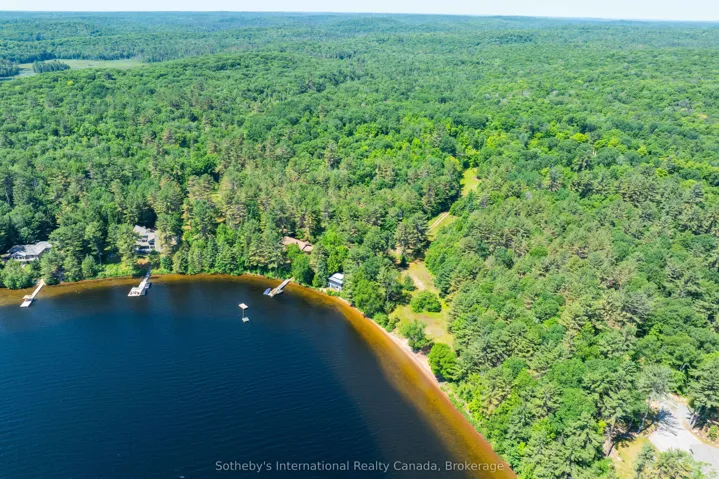
6 => Realtyna\MlsOnTheFly\Components\CloudPost\SubComponents\RFClient\SDK\RF\Entities\RFProperty {#14668
+post_id: ? mixed
+post_author: ? mixed
+"ListingKey": "X12342259"
+"ListingId": "X12342259"
+"PropertyType": "Residential"
+"PropertySubType": "Vacant Land"
+"StandardStatus": "Active"
+"ModificationTimestamp": "2025-09-21T07:33:16Z"
+"RFModificationTimestamp": "2025-09-21T07:37:43Z"
+"ListPrice": 369000.0
+"BathroomsTotalInteger": 0
+"BathroomsHalf": 0
+"BedroomsTotal": 0
+"LotSizeArea": 4.55
+"LivingArea": 0
+"BuildingAreaTotal": 0
+"City": "Seguin"
+"PostalCode": "P0C 1J0"
+"UnparsedAddress": "Lot 78 141 Highway, Seguin, ON P0C 1J0"
+"Coordinates": array:2 [
0 => -79.824262
1 => 45.2884039
]
+"Latitude": 45.2884039
+"Longitude": -79.824262
+"YearBuilt": 0
+"InternetAddressDisplayYN": true
+"FeedTypes": "IDX"
+"ListOfficeName": "Engel & Volkers Parry Sound"
+"OriginatingSystemName": "TRREB"
+"PublicRemarks": "Shadow River Riverfront Estate Lot | 4.55 Acres with 700' of Shoreline. Discover an extraordinary opportunity to craft your own Northern retreat on the tranquil shores of the Shadow River. This rare 4.55-acre estate lot offers an impressive 700 feet of private water frontage, set amidst a serene landscape of open meadow and scattered young hardwoods. Elevated well above the floodplain, the expansive 1.24-acre building envelope provides the ideal canvas for a grand main residence, extensive outdoor living spaces, and private amenities. Gently rolling and beautifully drained, the land invites elegant driveway approaches, manicured gardens, and sweeping river views. Enjoy peaceful paddles along the Shadow River or explore the nearby waters of Lake Rosseau, just minutes away. An MTO-approved driveway from Highway 141 ensures effortless year-round access, with the charming village of Rosseau only 5 minutes away, the Parry Sound Municipal Airport 20 minutes and Highway 400 just beyond. Unmatched in privacy, scale, and location, this is an opportunity perfect for those who dream of designing a riverfront estate that will be cherished for generations."
+"CityRegion": "Seguin"
+"Country": "CA"
+"CountyOrParish": "Parry Sound"
+"CreationDate": "2025-08-13T17:37:54.554797+00:00"
+"CrossStreet": "Nipissing & Hwy 141"
+"DirectionFaces": "North"
+"Directions": "Lake Joseph Road to Highway 141 - head east. Property on North Side. SOP."
+"Disclosures": array:1 [
0 => "Unknown"
]
+"ExpirationDate": "2025-12-31"
+"RFTransactionType": "For Sale"
+"InternetEntireListingDisplayYN": true
+"ListAOR": "One Point Association of REALTORS"
+"ListingContractDate": "2025-08-13"
+"LotSizeSource": "Survey"
+"MainOfficeKey": "575100"
+"MajorChangeTimestamp": "2025-08-13T17:18:27Z"
+"MlsStatus": "New"
+"OccupantType": "Vacant"
+"OriginalEntryTimestamp": "2025-08-13T17:18:27Z"
+"OriginalListPrice": 369000.0
+"OriginatingSystemID": "A00001796"
+"OriginatingSystemKey": "Draft2848048"
+"PhotosChangeTimestamp": "2025-08-13T17:18:27Z"
+"ShowingRequirements": array:1 [
0 => "Go Direct"
]
+"SignOnPropertyYN": true
+"SourceSystemID": "A00001796"
+"SourceSystemName": "Toronto Regional Real Estate Board"
+"StateOrProvince": "ON"
+"StreetName": "141"
+"StreetNumber": "Lot 78"
+"StreetSuffix": "Highway"
+"TaxLegalDescription": "Part of Lot 78, Concession B, Part of PIN 52199-0758(LT), Township of Humphrey, Now in the Township of Seguin, District of Parry Sound"
+"TaxYear": "2025"
+"TransactionBrokerCompensation": "2.5% + hst"
+"TransactionType": "For Sale"
+"VirtualTourURLBranded": "https://youtu.be/v WEWV9g RLNI"
+"WaterBodyName": "Shadow River"
+"WaterfrontFeatures": array:1 [
0 => "Not Applicable"
]
+"WaterfrontYN": true
+"Zoning": "RR & EP"
+"DDFYN": true
+"GasYNA": "No"
+"CableYNA": "No"
+"LotDepth": 763.45
+"LotWidth": 307.17
+"SewerYNA": "No"
+"WaterYNA": "No"
+"@odata.id": "https://api.realtyfeed.com/reso/odata/Property('X12342259')"
+"Shoreline": array:1 [
0 => "Natural"
]
+"WaterView": array:1 [
0 => "Direct"
]
+"SurveyType": "Available"
+"Waterfront": array:1 [
0 => "Direct"
]
+"DockingType": array:1 [
0 => "None"
]
+"ElectricYNA": "No"
+"HoldoverDays": 60
+"TelephoneYNA": "No"
+"WaterBodyType": "River"
+"provider_name": "TRREB"
+"ContractStatus": "Available"
+"HSTApplication": array:1 [
0 => "Included In"
]
+"PossessionType": "Immediate"
+"PriorMlsStatus": "Draft"
+"MortgageComment": "TAC"
+"AccessToProperty": array:2 [
0 => "Highway"
1 => "Public Road"
]
+"AlternativePower": array:1 [
0 => "None"
]
+"LotSizeAreaUnits": "Acres"
+"LotIrregularities": "Irregular"
+"LotSizeRangeAcres": "2-4.99"
+"PossessionDetails": "Immediate"
+"ShorelineAllowance": "None"
+"SpecialDesignation": array:1 [
0 => "Unknown"
]
+"WaterfrontAccessory": array:1 [
0 => "Not Applicable"
]
+"MediaChangeTimestamp": "2025-08-13T17:18:27Z"
+"SystemModificationTimestamp": "2025-09-21T07:33:16.446039Z"
+"Media": array:16 [
0 => array:26 [ …26]
1 => array:26 [ …26]
2 => array:26 [ …26]
3 => array:26 [ …26]
4 => array:26 [ …26]
5 => array:26 [ …26]
6 => array:26 [ …26]
7 => array:26 [ …26]
8 => array:26 [ …26]
9 => array:26 [ …26]
10 => array:26 [ …26]
11 => array:26 [ …26]
12 => array:26 [ …26]
13 => array:26 [ …26]
14 => array:26 [ …26]
15 => array:26 [ …26]
]
}
7 => Realtyna\MlsOnTheFly\Components\CloudPost\SubComponents\RFClient\SDK\RF\Entities\RFProperty {#14669
+post_id: ? mixed
+post_author: ? mixed
+"ListingKey": "X12342111"
+"ListingId": "X12342111"
+"PropertyType": "Residential"
+"PropertySubType": "Vacant Land"
+"StandardStatus": "Active"
+"ModificationTimestamp": "2025-09-21T07:30:45Z"
+"RFModificationTimestamp": "2025-09-21T07:33:40Z"
+"ListPrice": 800000.0
+"BathroomsTotalInteger": 0
+"BathroomsHalf": 0
+"BedroomsTotal": 0
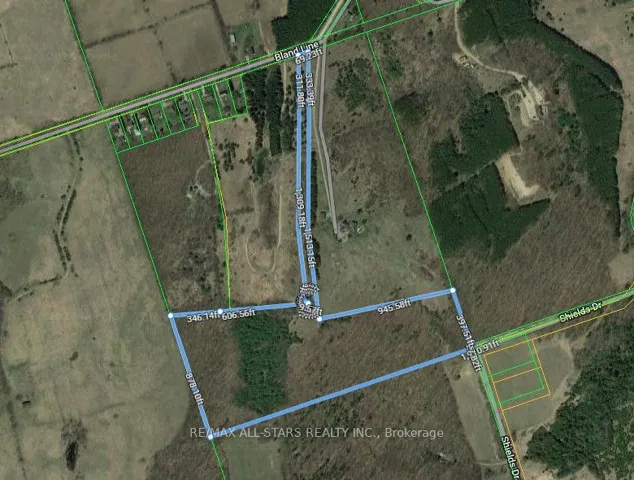
+"LotSizeArea": 30.0
+"LivingArea": 0
+"BuildingAreaTotal": 0
+"City": "Grey Highlands"
+"PostalCode": "N0C 1C0"
+"UnparsedAddress": "448020 10th Concession, Grey Highlands, ON N0C 1C0"
+"Coordinates": array:2 [
0 => -80.4603896
1 => 44.3565469
]
+"Latitude": 44.3565469
+"Longitude": -80.4603896
+"YearBuilt": 0
+"InternetAddressDisplayYN": true
+"FeedTypes": "IDX"
+"ListOfficeName": "Royal Le Page RCR Realty"
+"OriginatingSystemName": "TRREB"
+"PublicRemarks": "30 acre corner property with 3 acre spring-fed pond near Feversham. Beautiful setting with driveway, well and former building site overlooking the pond. Hydro is available at the road. There are approximately 16 acres currently planted in corn and hardwood trees along the original fenceline. Located in an agricultural community 20 minutes from Collingwood. Great location for a custom home."
+"CityRegion": "Grey Highlands"
+"CoListOfficeName": "Royal Le Page RCR Realty"
+"CoListOfficePhone": "519-924-2950"
+"CountyOrParish": "Grey County"
+"CreationDate": "2025-08-13T16:35:27.292239+00:00"
+"CrossStreet": "10th Concession / SR 45"
+"DirectionFaces": "South"
+"Directions": "South East Corner of Sideroad 45 and 10th Concession"
+"ExpirationDate": "2026-02-09"
+"RFTransactionType": "For Sale"
+"InternetEntireListingDisplayYN": true
+"ListAOR": "One Point Association of REALTORS"
+"ListingContractDate": "2025-08-09"
+"MainOfficeKey": "571600"
+"MajorChangeTimestamp": "2025-08-13T16:32:50Z"
+"MlsStatus": "New"
+"OccupantType": "Vacant"
+"OriginalEntryTimestamp": "2025-08-13T16:32:50Z"
+"OriginalListPrice": 800000.0
+"OriginatingSystemID": "A00001796"
+"OriginatingSystemKey": "Draft2842430"
+"ParcelNumber": "372550356"
+"PhotosChangeTimestamp": "2025-08-14T18:29:08Z"
+"ShowingRequirements": array:1 [
0 => "Go Direct"
]
+"SignOnPropertyYN": true
+"SourceSystemID": "A00001796"
+"SourceSystemName": "Toronto Regional Real Estate Board"
+"StateOrProvince": "ON"
+"StreetName": "10th"
+"StreetNumber": "448020"
+"StreetSuffix": "Concession"
+"TaxAnnualAmount": "2415.66"
+"TaxAssessedValue": 171000
+"TaxLegalDescription": "Part Lot 11 Concession 10 as in GS65446 (Osprey) Municipality of Grey Highlands, County of Grey"
+"TaxYear": "2025"
+"TransactionBrokerCompensation": "2.0% +HST *See Remarks"
+"TransactionType": "For Sale"
+"Zoning": "A1, H"
+"DDFYN": true
+"Water": "Well"
+"GasYNA": "No"
+"CableYNA": "No"
+"LotDepth": 1552.0
+"LotWidth": 845.0
+"SewerYNA": "No"
+"WaterYNA": "No"
+"@odata.id": "https://api.realtyfeed.com/reso/odata/Property('X12342111')"
+"RollNumber": "420814000605310"
+"SurveyType": "None"
+"Waterfront": array:1 [
0 => "None"
]
+"ElectricYNA": "Available"
+"TelephoneYNA": "Available"
+"provider_name": "TRREB"
+"AssessmentYear": 2025
+"ContractStatus": "Available"
+"HSTApplication": array:1 [
0 => "Not Subject to HST"
]
+"PossessionType": "Immediate"
+"PriorMlsStatus": "Draft"
+"LotSizeAreaUnits": "Acres"
+"PropertyFeatures": array:1 [
0 => "Lake/Pond"
]
+"LotSizeRangeAcres": "25-49.99"
+"PossessionDetails": "Flexible"
+"SpecialDesignation": array:1 [
0 => "Unknown"
]
+"MediaChangeTimestamp": "2025-08-14T18:29:08Z"
+"SystemModificationTimestamp": "2025-09-21T07:30:45.632159Z"
+"Media": array:8 [
0 => array:26 [ …26]
1 => array:26 [ …26]
2 => array:26 [ …26]
3 => array:26 [ …26]
4 => array:26 [ …26]
5 => array:26 [ …26]
6 => array:26 [ …26]
7 => array:26 [ …26]
]
}
8 => Realtyna\MlsOnTheFly\Components\CloudPost\SubComponents\RFClient\SDK\RF\Entities\RFProperty {#14670
+post_id: ? mixed
+post_author: ? mixed
+"ListingKey": "X12341820"
+"ListingId": "X12341820"
+"PropertyType": "Residential"
+"PropertySubType": "Vacant Land"
+"StandardStatus": "Active"
+"ModificationTimestamp": "2025-09-21T07:25:07Z"
+"RFModificationTimestamp": "2025-09-21T07:29:07Z"
+"ListPrice": 369000.0
+"BathroomsTotalInteger": 0
+"BathroomsHalf": 0
+"BedroomsTotal": 0
+"LotSizeArea": 1.097
+"LivingArea": 0
+"BuildingAreaTotal": 0
+"City": "Fort Erie"
+"PostalCode": "L0S 1N0"
+"UnparsedAddress": "Part B - 345 Stonemill Road, Fort Erie, ON L0S 1N0"
+"Coordinates": array:2 [
0 => -78.918611
1 => 42.91308
]
+"Latitude": 42.91308
+"Longitude": -78.918611
+"YearBuilt": 0
+"InternetAddressDisplayYN": true
+"FeedTypes": "IDX"
+"ListOfficeName": "ROYAL LEPAGE NRC REALTY"
+"OriginatingSystemName": "TRREB"
+"PublicRemarks": "Heres your chance to build your dreamhome on a one of a kind 1.097 acre lot on Stonemill Road in Fort Erie! This lot has 150.92 feet of Frontage and a depth of 310 feet! The lots south side runs 310 feet down the friendship trail, and is directly beside Windmill point! At the end of the road is the Stonemill waterfront window, which provides sand beach access. Quick access to garrison road for all your amenities, and quick access to ridgeway downtown and crystal beach! Bring your vision!"
+"CityRegion": "335 - Ridgeway"
+"CountyOrParish": "Niagara"
+"CreationDate": "2025-08-13T15:36:00.836152+00:00"
+"CrossStreet": "Dominion/Stonemill"
+"DirectionFaces": "West"
+"Directions": "Dominion to Stonemill towards lake"
+"ExpirationDate": "2026-05-31"
+"RFTransactionType": "For Sale"
+"InternetEntireListingDisplayYN": true
+"ListAOR": "Niagara Association of REALTORS"
+"ListingContractDate": "2025-08-13"
+"MainOfficeKey": "292600"
+"MajorChangeTimestamp": "2025-08-13T15:24:58Z"
+"MlsStatus": "New"
+"OccupantType": "Vacant"
+"OriginalEntryTimestamp": "2025-08-13T15:24:58Z"
+"OriginalListPrice": 369000.0
+"OriginatingSystemID": "A00001796"
+"OriginatingSystemKey": "Draft2795774"
+"PhotosChangeTimestamp": "2025-08-13T15:24:58Z"
+"ShowingRequirements": array:1 [
0 => "Go Direct"
]
+"SignOnPropertyYN": true
+"SourceSystemID": "A00001796"
+"SourceSystemName": "Toronto Regional Real Estate Board"
+"StateOrProvince": "ON"
+"StreetName": "Stonemill"
+"StreetNumber": "Part B - 345"
+"StreetSuffix": "Road"
+"TaxLegalDescription": "PT LT 13 CON 1 LAKE ERIE BERTIE AS IN RO87308 & BE46539 EXCEPT RO163246, RO156402 & RO157789; S/T BE45757; FORT ERIE"
+"TaxYear": "2025"
+"TransactionBrokerCompensation": "2% plus hst"
+"TransactionType": "For Sale"
+"DDFYN": true
+"GasYNA": "Available"
+"CableYNA": "Available"
+"LotDepth": 94.5
+"LotWidth": 46.0
+"SewerYNA": "No"
+"WaterYNA": "No"
+"@odata.id": "https://api.realtyfeed.com/reso/odata/Property('X12341820')"
+"SurveyType": "Available"
+"Waterfront": array:1 [
0 => "Indirect"
]
+"ElectricYNA": "Available"
+"HoldoverDays": 30
+"TelephoneYNA": "Available"
+"provider_name": "TRREB"
+"ContractStatus": "Available"
+"HSTApplication": array:1 [
0 => "Included In"
]
+"PossessionType": "Flexible"
+"PriorMlsStatus": "Draft"
+"LotSizeAreaUnits": "Acres"
+"LotSizeRangeAcres": ".50-1.99"
+"PossessionDetails": "asap"
+"SpecialDesignation": array:1 [
0 => "Unknown"
]
+"MediaChangeTimestamp": "2025-08-18T18:30:11Z"
+"SystemModificationTimestamp": "2025-09-21T07:25:07.739582Z"
+"PermissionToContactListingBrokerToAdvertise": true
+"Media": array:5 [
0 => array:26 [ …26]
1 => array:26 [ …26]
2 => array:26 [ …26]
3 => array:26 [ …26]
4 => array:26 [ …26]
]
}
9 => Realtyna\MlsOnTheFly\Components\CloudPost\SubComponents\RFClient\SDK\RF\Entities\RFProperty {#14673
+post_id: ? mixed
+post_author: ? mixed
+"ListingKey": "X12341713"
+"ListingId": "X12341713"
+"PropertyType": "Residential"
+"PropertySubType": "Vacant Land"
+"StandardStatus": "Active"
+"ModificationTimestamp": "2025-09-21T07:22:54Z"
+"RFModificationTimestamp": "2025-09-21T07:25:40Z"
+"ListPrice": 60000.0
+"BathroomsTotalInteger": 0
+"BathroomsHalf": 0
+"BedroomsTotal": 0
+"LotSizeArea": 1.28
+"LivingArea": 0
+"BuildingAreaTotal": 0
+"City": "Russell"
+"PostalCode": "K4R 1E5"
+"UnparsedAddress": "00 North Russell Road, Russell, ON K4R 1E5"
+"Coordinates": array:2 [
0 => -75.393098
1 => 45.3204297
]
+"Latitude": 45.3204297
+"Longitude": -75.393098
+"YearBuilt": 0
+"InternetAddressDisplayYN": true
+"FeedTypes": "IDX"
+"ListOfficeName": "EXP REALTY"
+"OriginatingSystemName": "TRREB"
+"PublicRemarks": "Unique 1.28-Acre Parcel Just North of Russell. Discover the perfect blend of rural charm and convenience with this unique 1.28-acre parcel located just minutes north of the Village of Russell. Zoned A2 (see attachment for permitted uses), this property offers incredible potential for your vision whether you're looking to build a home, or explore other opportunities. Enjoy expansive, views of surrounding farmland, offering a peaceful setting and plenty of open space. The propertys location provides easy access to local amenities, schools, and community events while allowing you to embrace the quiet beauty of country living. Bring your ideas, roll up your sleeves, and make this special property your own."
+"CityRegion": "603 - Russell Twp"
+"Country": "CA"
+"CountyOrParish": "Prescott and Russell"
+"CreationDate": "2025-08-13T15:17:07.091562+00:00"
+"CrossStreet": "Burton Road and North Russell Road"
+"DirectionFaces": "North"
+"Directions": "Exit 417 @ Boundary Road, exit 96. Travel South on Boundary Road to Devine Road. Turn Left on Devine. Turn Right on Frontier Road. Property is located on the Left had side where the road curves and changes to North Russell Road."
+"ExpirationDate": "2025-12-12"
+"RFTransactionType": "For Sale"
+"InternetEntireListingDisplayYN": true
+"ListAOR": "Ottawa Real Estate Board"
+"ListingContractDate": "2025-08-12"
+"LotSizeSource": "Geo Warehouse"
+"MainOfficeKey": "488700"
+"MajorChangeTimestamp": "2025-09-11T15:40:50Z"
+"MlsStatus": "New"
+"OccupantType": "Vacant"
+"OriginalEntryTimestamp": "2025-08-13T15:02:57Z"
+"OriginalListPrice": 60000.0
+"OriginatingSystemID": "A00001796"
+"OriginatingSystemKey": "Draft2845492"
+"ParcelNumber": "690000047"
+"PhotosChangeTimestamp": "2025-08-13T15:02:58Z"
+"ShowingRequirements": array:2 [
0 => "Go Direct"
1 => "Showing System"
]
+"SignOnPropertyYN": true
+"SourceSystemID": "A00001796"
+"SourceSystemName": "Toronto Regional Real Estate Board"
+"StateOrProvince": "ON"
+"StreetName": "North Russell"
+"StreetNumber": "00"
+"StreetSuffix": "Road"
+"TaxAnnualAmount": "124.0"
+"TaxLegalDescription": "PT LT 23, CON 2 Russell PT 4, 50R2849; RUSSELL"
+"TaxYear": "2025"
+"Topography": array:1 [
0 => "Flat"
]
+"TransactionBrokerCompensation": "2.0"
+"TransactionType": "For Sale"
+"Zoning": "A2"
+"DDFYN": true
+"GasYNA": "No"
+"CableYNA": "Available"
+"LotDepth": 440.13
+"LotShape": "Irregular"
+"LotWidth": 484.32
+"SewerYNA": "No"
+"WaterYNA": "No"
+"@odata.id": "https://api.realtyfeed.com/reso/odata/Property('X12341713')"
+"RollNumber": "30600000207800"
+"SurveyType": "None"
+"Waterfront": array:1 [
0 => "None"
]
+"ElectricYNA": "Available"
+"HoldoverDays": 90
+"TelephoneYNA": "Available"
+"provider_name": "TRREB"
+"ContractStatus": "Available"
+"HSTApplication": array:1 [
0 => "In Addition To"
]
+"PossessionType": "Immediate"
+"PriorMlsStatus": "Sold Conditional"
+"LotSizeAreaUnits": "Acres"
+"LotSizeRangeAcres": ".50-1.99"
+"PossessionDetails": "Immediate"
+"SpecialDesignation": array:1 [
0 => "Unknown"
]
+"MediaChangeTimestamp": "2025-08-15T23:35:19Z"
+"DevelopmentChargesPaid": array:1 [
0 => "Unknown"
]
+"SystemModificationTimestamp": "2025-09-21T07:22:54.991431Z"
+"SoldConditionalEntryTimestamp": "2025-08-25T12:49:20Z"
+"PermissionToContactListingBrokerToAdvertise": true
+"Media": array:1 [
0 => array:26 [ …26]
]
}
]
+success: true
+page_size: 10
+page_count: 297
+count: 2964
+after_key: ""
}
]
"RF Query: /Property?$select=ALL&$orderby=meta_value date DESC&$top=10&$skip=2520&$filter=(StandardStatus eq 'Active') and PropertyType in ('Residential', 'Residential Income', 'Residential Lease') AND PropertySubType eq 'Vacant Land'/Property?$select=ALL&$orderby=meta_value date DESC&$top=10&$skip=2520&$filter=(StandardStatus eq 'Active') and PropertyType in ('Residential', 'Residential Income', 'Residential Lease') AND PropertySubType eq 'Vacant Land'&$expand=Media/Property?$select=ALL&$orderby=meta_value date DESC&$top=10&$skip=2520&$filter=(StandardStatus eq 'Active') and PropertyType in ('Residential', 'Residential Income', 'Residential Lease') AND PropertySubType eq 'Vacant Land'/Property?$select=ALL&$orderby=meta_value date DESC&$top=10&$skip=2520&$filter=(StandardStatus eq 'Active') and PropertyType in ('Residential', 'Residential Income', 'Residential Lease') AND PropertySubType eq 'Vacant Land'&$expand=Media&$count=true" => array:2 [
"RF Response" => Realtyna\MlsOnTheFly\Components\CloudPost\SubComponents\RFClient\SDK\RF\RFResponse {#14598
+items: array:10 [
0 => Realtyna\MlsOnTheFly\Components\CloudPost\SubComponents\RFClient\SDK\RF\Entities\RFProperty {#14609
+post_id: "613646"
+post_author: 1
+"ListingKey": "E12492392"
+"ListingId": "E12492392"
+"PropertyType": "Residential"
+"PropertySubType": "Vacant Land"
+"StandardStatus": "Active"
+"ModificationTimestamp": "2025-10-30T17:57:39Z"
+"RFModificationTimestamp": "2025-11-08T15:10:39Z"
+"ListPrice": 7999000.0
+"BathroomsTotalInteger": 0
+"BathroomsHalf": 0
+"BedroomsTotal": 0
+"LotSizeArea": 0
+"LivingArea": 0
+"BuildingAreaTotal": 0
+"City": "Whitby"
+"PostalCode": "L1N 4M7"
+"UnparsedAddress": "1717 Brock Street S, Whitby, ON L1N 4M7"
+"Coordinates": array:2 [
0 => -78.9333141
1 => 43.859569
]
+"Latitude": 43.859569
+"Longitude": -78.9333141
+"YearBuilt": 0
+"InternetAddressDisplayYN": true
+"FeedTypes": "IDX"
+"ListOfficeName": "CENTURY 21 LEADING EDGE REALTY INC."
+"OriginatingSystemName": "TRREB"
+"PublicRemarks": "Exciting Development Opportunity in the Heart of Port of Whitby! Zoning Approved for a Mixed-Use Building just steps from the Whitby Habour, this land offers exceptional development potential with architectural drawings available and site plan approval expected shortly. The proposed development features: 30 Condominium Units and 4 Semi-Detached Units. Total Mixed-Use Area: 38,966.29 sq. ft. Commercial Space: 1,620.40 sq. ft. Residential Space: 37,345.89 sq. ft. Semi-Detached Units: 13,341.74 sq. ft. total. Parking: 52 spaces for the mixed-use building (including 3 accessible, 45 residential, and 7 commercial) and 8 spaces for the semi-detached units (2 per unit). Perfectly positioned in the heart of the Port of Whitby, this property offers proximity to the water's edge, marina, shops, restaurants, transit, and future growth corridor. A rare opportunity to build a signature development in one of Durham Region's most desirable waterfront communities."
+"AttachedGarageYN": true
+"CityRegion": "Port Whitby"
+"CoListOfficeName": "CENTURY 21 LEADING EDGE REALTY INC."
+"CoListOfficePhone": "905-471-2121"
+"Country": "CA"
+"CountyOrParish": "Durham"
+"CreationDate": "2025-10-30T18:07:27.971041+00:00"
+"CrossStreet": "Victoria Rd E & Brock St S"
+"DirectionFaces": "East"
+"Directions": "Victoria Rd E & Brock St S"
+"ExpirationDate": "2026-02-28"
+"GarageYN": true
+"RFTransactionType": "For Sale"
+"InternetEntireListingDisplayYN": true
+"ListAOR": "Toronto Regional Real Estate Board"
+"ListingContractDate": "2025-10-30"
+"LotDimensionsSource": "Other"
+"LotSizeDimensions": "107.28 x 299.54 Feet"
+"MainOfficeKey": "089800"
+"MajorChangeTimestamp": "2025-10-30T17:57:39Z"
+"MlsStatus": "New"
+"OccupantType": "Vacant"
+"OriginalEntryTimestamp": "2025-10-30T17:57:39Z"
+"OriginalListPrice": 7999000.0
+"OriginatingSystemID": "A00001796"
+"OriginatingSystemKey": "Draft3186070"
+"PhotosChangeTimestamp": "2025-10-30T17:57:39Z"
+"ShowingRequirements": array:1 [
0 => "Showing System"
]
+"SourceSystemID": "A00001796"
+"SourceSystemName": "Toronto Regional Real Estate Board"
+"StateOrProvince": "ON"
+"StreetDirSuffix": "S"
+"StreetName": "Brock"
+"StreetNumber": "1717"
+"StreetSuffix": "Street"
+"TaxAnnualAmount": "7074.0"
+"TaxLegalDescription": "PT LT 11 BLK 1 PL H50035 WHITBY; PT LT 12 BLK 1 PL H50035 WHITBY PT 1, 40R7004; WHITBY"
+"TaxYear": "2025"
+"TransactionBrokerCompensation": "2.5%"
+"TransactionType": "For Sale"
+"DDFYN": true
+"Water": "Municipal"
+"GasYNA": "Available"
+"CableYNA": "Available"
+"LotDepth": 210.29
+"LotWidth": 107.35
+"SewerYNA": "Available"
+"WaterYNA": "Available"
+"@odata.id": "https://api.realtyfeed.com/reso/odata/Property('E12492392')"
+"PictureYN": true
+"SurveyType": "Boundary Only"
+"Waterfront": array:1 [
0 => "None"
]
+"ElectricYNA": "Available"
+"TelephoneYNA": "Available"
+"provider_name": "TRREB"
+"short_address": "Whitby, ON L1N 4M7, CA"
+"ContractStatus": "Available"
+"HSTApplication": array:1 [
0 => "Included In"
]
+"PossessionType": "Flexible"
+"PriorMlsStatus": "Draft"
+"StreetSuffixCode": "St"
+"BoardPropertyType": "Com"
+"LotSizeRangeAcres": "< .50"
+"PossessionDetails": "Flexible"
+"SpecialDesignation": array:1 [
0 => "Unknown"
]
+"MediaChangeTimestamp": "2025-10-30T17:57:39Z"
+"MLSAreaDistrictOldZone": "E19"
+"MLSAreaMunicipalityDistrict": "Whitby"
+"SystemModificationTimestamp": "2025-10-30T17:57:39.457357Z"
+"Media": array:24 [
0 => array:26 [ …26]
1 => array:26 [ …26]
2 => array:26 [ …26]
3 => array:26 [ …26]
4 => array:26 [ …26]
5 => array:26 [ …26]
6 => array:26 [ …26]
7 => array:26 [ …26]
8 => array:26 [ …26]
9 => array:26 [ …26]
10 => array:26 [ …26]
11 => array:26 [ …26]
12 => array:26 [ …26]
13 => array:26 [ …26]
14 => array:26 [ …26]
15 => array:26 [ …26]
16 => array:26 [ …26]
17 => array:26 [ …26]
18 => array:26 [ …26]
19 => array:26 [ …26]
20 => array:26 [ …26]
21 => array:26 [ …26]
22 => array:26 [ …26]
23 => array:26 [ …26]
]
+"ID": "613646"
}
1 => Realtyna\MlsOnTheFly\Components\CloudPost\SubComponents\RFClient\SDK\RF\Entities\RFProperty {#14608
+post_id: "613648"
+post_author: 1
+"ListingKey": "W12493300"
+"ListingId": "W12493300"
+"PropertyType": "Residential"
+"PropertySubType": "Vacant Land"
+"StandardStatus": "Active"
+"ModificationTimestamp": "2025-10-30T20:08:23Z"
+"RFModificationTimestamp": "2025-11-10T16:23:12Z"
+"ListPrice": 5500000.0
+"BathroomsTotalInteger": 0
+"BathroomsHalf": 0
+"BedroomsTotal": 0
+"LotSizeArea": 2.78
+"LivingArea": 0
+"BuildingAreaTotal": 0
+"City": "Burlington"
+"PostalCode": "L7T 4G9"
+"UnparsedAddress": "800 Lasalle Park Road, Burlington, ON L7T 4G9"
+"Coordinates": array:2 [
0 => -79.8459131
1 => 43.300713
]
+"Latitude": 43.300713
+"Longitude": -79.8459131
+"YearBuilt": 0
+"InternetAddressDisplayYN": true
+"FeedTypes": "IDX"
+"ListOfficeName": "ROYAL LEPAGE BURLOAK REAL ESTATE SERVICES"
+"OriginatingSystemName": "TRREB"
+"PublicRemarks": "Once-in-a-lifetime waterfront opportunity in Burlington's sought-after Aldershot community! Nestled on over 2.7 acres of prime waterfront property, this incredible offering features direct, unobstructed water views and riparian rights, including your very own private boat slip - a rare find in this area! Tucked away on a quiet, desirable cul-de-sac, this property offers endless possibilities. Build your dream waterfront estate. create a family retreat, or redevelop the land to match your vision - the lifestyle potential here is truly unmatched. With direct access to the water, you can boat, kayak, or paddleboard right from your own backyard. Surrounded by natural beauty and urban conveniences, you're steps to the marina, trails, splash pad, pool. beach, and the charming La Salle Park Pavilion. Whether you're looking for peaceful nature walks, family-friendly activities, or a vibrant social scene, it's all right here. Plus, enjoy easy access to major highways and be just minutes from downtown Burlington's shops. restaurants, and waterfront parks. This is a rare chance to secure a generational property in one of Burlington's most coveted neighbourhoods. Don't miss the opportunity to make your waterfront dreams a reality!"
+"ArchitecturalStyle": "Other"
+"Basement": array:2 [
0 => "None"
1 => "Development Potential"
]
+"CityRegion": "Bayview"
+"CoListOfficeName": "ROYAL LEPAGE BURLOAK REAL ESTATE SERVICES"
+"CoListOfficePhone": "905-844-2022"
+"ConstructionMaterials": array:1 [
0 => "Other"
]
+"Cooling": "Other"
+"Country": "CA"
+"CountyOrParish": "Halton"
+"CreationDate": "2025-10-30T20:17:52.597996+00:00"
+"CrossStreet": "Lasalle Park Road, South of North Shore Blvd W"
+"DirectionFaces": "West"
+"Directions": "North Shore Blvd & Lasalle Park Road"
+"Disclosures": array:1 [
0 => "Conservation Regulations"
]
+"Exclusions": "None"
+"ExpirationDate": "2026-01-28"
+"Inclusions": "None"
+"InteriorFeatures": "None,Other"
+"RFTransactionType": "For Sale"
+"InternetEntireListingDisplayYN": true
+"ListAOR": "Toronto Regional Real Estate Board"
+"ListingContractDate": "2025-10-30"
+"MainOfficeKey": "190200"
+"MajorChangeTimestamp": "2025-10-30T20:08:23Z"
+"MlsStatus": "New"
+"OccupantType": "Vacant"
+"OriginalEntryTimestamp": "2025-10-30T20:08:23Z"
+"OriginalListPrice": 5500000.0
+"OriginatingSystemID": "A00001796"
+"OriginatingSystemKey": "Draft3200686"
+"ParcelNumber": "071160056"
+"ParkingFeatures": "Private,Other"
+"PhotosChangeTimestamp": "2025-10-30T20:08:23Z"
+"Sewer": "Sewer"
+"ShowingRequirements": array:1 [
0 => "See Brokerage Remarks"
]
+"SourceSystemID": "A00001796"
+"SourceSystemName": "Toronto Regional Real Estate Board"
+"StateOrProvince": "ON"
+"StreetName": "Lasalle Park"
+"StreetNumber": "800"
+"StreetSuffix": "Road"
+"TaxAnnualAmount": "15049.92"
+"TaxLegalDescription": "PCL BLK 34-1 , SEC 20M276 ; BLK 34, PL 20M276 , S/T PT 1 20R5897, IN FAVOUR OF LT 1 PL 20M276 AS IN H298921A; T/W PT LT 1 PL 20M276, PT 2 20R5897 AS IN H298921A ; S/T H190811,H190832 BURLINGTON, PIN: 07116-0056; PT LT 47, PL PF642 ; PT LT 7 , CON BROKEN FRONT ; PT OF WATER LT IN FRONT OF LT 7 CON BROKEN FRONT AS IN 739925 ; BURLINGTON/E FLAM TWP, PIN: 07116-0091 (* See Supplements)"
+"TaxYear": "2025"
+"TransactionBrokerCompensation": "2% up to $500,000, 1% on balance"
+"TransactionType": "For Sale"
+"View": array:1 [
0 => "Lake"
]
+"VirtualTourURLBranded": "http://youtube.com/watch?v=a Zmhsi ZZPFE"
+"VirtualTourURLUnbranded": "https://www.youtube.com/watch?v=p6y OLB0y Gd M"
+"WaterBodyName": "Lake Ontario"
+"WaterfrontFeatures": "Boat Slip"
+"WaterfrontYN": true
+"Zoning": "R2.2-55"
+"DDFYN": true
+"Water": "Municipal"
+"GasYNA": "Available"
+"CableYNA": "Available"
+"HeatType": "Other"
+"LotDepth": 275.0
+"LotShape": "Irregular"
+"LotWidth": 430.0
+"SewerYNA": "Available"
+"WaterYNA": "Available"
+"@odata.id": "https://api.realtyfeed.com/reso/odata/Property('W12493300')"
+"Shoreline": array:2 [
0 => "Sandy"
1 => "Deep"
]
+"WaterView": array:2 [
0 => "Direct"
1 => "Unobstructive"
]
+"HeatSource": "Other"
+"RollNumber": "240201011008400"
+"SurveyType": "Unknown"
+"Waterfront": array:1 [
0 => "Direct"
]
+"DockingType": array:1 [
0 => "Private"
]
+"ElectricYNA": "Available"
+"HoldoverDays": 30
+"TelephoneYNA": "Available"
+"WaterBodyType": "Lake"
+"provider_name": "TRREB"
+"short_address": "Burlington, ON L7T 4G9, CA"
+"ContractStatus": "Available"
+"HSTApplication": array:1 [
0 => "Not Subject to HST"
]
+"PossessionType": "Flexible"
+"PriorMlsStatus": "Draft"
+"RuralUtilities": array:1 [
0 => "Cable Available"
]
+"LivingAreaRange": "< 700"
+"WaterFrontageFt": "430"
+"AccessToProperty": array:1 [
0 => "Public Road"
]
+"AlternativePower": array:1 [
0 => "None"
]
+"PropertyFeatures": array:6 [
0 => "Cul de Sac/Dead End"
1 => "Golf"
2 => "Lake Access"
3 => "Lake/Pond"
4 => "Marina"
5 => "Park"
]
+"LotIrregularities": "375.75ft.x274.58ft.x306.( See Remarks)"
+"LotSizeRangeAcres": "2-4.99"
+"PossessionDetails": "Flexible"
+"ShorelineAllowance": "None"
+"SpecialDesignation": array:1 [
0 => "Unknown"
]
+"WaterfrontAccessory": array:1 [
0 => "Single Slip"
]
+"MediaChangeTimestamp": "2025-10-30T20:08:23Z"
+"SystemModificationTimestamp": "2025-10-30T20:08:24.162284Z"
+"Media": array:20 [
0 => array:26 [ …26]
1 => array:26 [ …26]
2 => array:26 [ …26]
3 => array:26 [ …26]
4 => array:26 [ …26]
5 => array:26 [ …26]
6 => array:26 [ …26]
7 => array:26 [ …26]
8 => array:26 [ …26]
9 => array:26 [ …26]
10 => array:26 [ …26]
11 => array:26 [ …26]
12 => array:26 [ …26]
13 => array:26 [ …26]
14 => array:26 [ …26]
15 => array:26 [ …26]
16 => array:26 [ …26]
17 => array:26 [ …26]
18 => array:26 [ …26]
19 => array:26 [ …26]
]
+"ID": "613648"
}
2 => Realtyna\MlsOnTheFly\Components\CloudPost\SubComponents\RFClient\SDK\RF\Entities\RFProperty {#14605
+post_id: "613148"
+post_author: 1
+"ListingKey": "X12493644"
+"ListingId": "X12493644"
+"PropertyType": "Residential"
+"PropertySubType": "Vacant Land"
+"StandardStatus": "Active"
+"ModificationTimestamp": "2025-10-30T22:40:48Z"
+"RFModificationTimestamp": "2025-11-07T16:19:25Z"
+"ListPrice": 229900.0
+"BathroomsTotalInteger": 0
+"BathroomsHalf": 0
+"BedroomsTotal": 0
+"LotSizeArea": 1.98
+"LivingArea": 0
+"BuildingAreaTotal": 0
+"City": "Trent Lakes"
+"PostalCode": "K0M 1A0"
+"UnparsedAddress": "Pt Lt 20 Fire Route 121 N/a, Trent Lakes, ON K0M 1A0"
+"Coordinates": array:2 [
0 => -78.4253243
1 => 44.6630272
]
+"Latitude": 44.6630272
+"Longitude": -78.4253243
+"YearBuilt": 0
+"InternetAddressDisplayYN": true
+"FeedTypes": "IDX"
+"ListOfficeName": "ROYAL LEPAGE FRANK REAL ESTATE"
+"OriginatingSystemName": "TRREB"
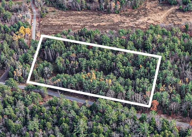
+"PublicRemarks": "Welcome to your slice of paradise near beautiful Pigeon Lake in the heart of the Trent Lakes. This 1.98-acre property offers the perfect blend of peace and proximity to everything Bobcaygeon has to offer. With deeded water access just steps away. You can enjoy boating fishing, swimming, and scenic sunsets on the Trent-Severn Waterway - all while designing and building your dream home or cottage retreat. Public boat launch just a short drive on County Road 36 N. Zoned Rural Residential (RU), this lot provides excellent flexibility for your future plans. The mostly level landscape and mature tree lines create a picturesque setting, ideal for a custom home, hobby retreat, or year-round getaway. Bring your imagination, and your love for country living - this is the opportunity you've been waiting for. Located only minutes from Bobcaygeon's shops, restaurants, and marinas, this property perfectly balances tranquility and convenience. Whether you're envisioning a modern family home or a cozy countryside escape, the possibilities are endless. Minutes to Bobcaygeon, Buckhorn, Lindsay and Peterborough."
+"CityRegion": "Trent Lakes"
+"Country": "CA"
+"CountyOrParish": "Peterborough"
+"CreationDate": "2025-10-30T21:22:57.151264+00:00"
+"CrossStreet": "County Rd 36 N/Fire Route 121"
+"DirectionFaces": "South"
+"Directions": "County Rd 36 north of Bobcaygeon approx 5km to Fire Route 121 on the right hand side."
+"ExpirationDate": "2025-12-31"
+"Inclusions": "None"
+"RFTransactionType": "For Sale"
+"InternetEntireListingDisplayYN": true
+"ListAOR": "Central Lakes Association of REALTORS"
+"ListingContractDate": "2025-10-30"
+"LotSizeSource": "Survey"
+"MainOfficeKey": "522700"
+"MajorChangeTimestamp": "2025-10-30T21:14:44Z"
+"MlsStatus": "New"
+"OccupantType": "Vacant"
+"OriginalEntryTimestamp": "2025-10-30T21:14:44Z"
+"OriginalListPrice": 229900.0
+"OriginatingSystemID": "A00001796"
+"OriginatingSystemKey": "Draft3184152"
+"ParcelNumber": "283520328"
+"PhotosChangeTimestamp": "2025-10-30T21:14:44Z"
+"ShowingRequirements": array:1 [
0 => "Showing System"
]
+"SourceSystemID": "A00001796"
+"SourceSystemName": "Toronto Regional Real Estate Board"
+"StateOrProvince": "ON"
+"StreetName": "FIRE ROUTE 121"
+"StreetNumber": "PT LT 20"
+"StreetSuffix": "N/A"
+"TaxAnnualAmount": "480.0"
+"TaxLegalDescription": "PT LT 20 CON 17 HARVEY PT 1, 4 45R4263 S/T & T/W R382157; S/T N4758; GAL-CAV AND HAR"
+"TaxYear": "2025"
+"Topography": array:3 [
0 => "Flat"
1 => "Open Space"
2 => "Partially Cleared"
]
+"TransactionBrokerCompensation": "2.25"
+"TransactionType": "For Sale"
+"WaterfrontFeatures": "Waterfront-Deeded Access"
+"Zoning": "Rural Res"
+"DDFYN": true
+"GasYNA": "No"
+"CableYNA": "No"
+"LotDepth": 257.0
+"LotShape": "Irregular"
+"LotWidth": 340.0
+"SewerYNA": "No"
+"WaterYNA": "No"
+"@odata.id": "https://api.realtyfeed.com/reso/odata/Property('X12493644')"
+"RollNumber": "154201000293302"
+"SurveyType": "Available"
+"Waterfront": array:1 [
0 => "Indirect"
]
+"ElectricYNA": "No"
+"RentalItems": "None"
+"HoldoverDays": 60
+"TelephoneYNA": "No"
+"provider_name": "TRREB"
+"ContractStatus": "Available"
+"HSTApplication": array:1 [
0 => "In Addition To"
]
+"PossessionType": "Immediate"
+"PriorMlsStatus": "Draft"
+"LotSizeAreaUnits": "Acres"
+"LotIrregularities": "Plus 200.10 ft x 50.07 ft Part 4"
+"LotSizeRangeAcres": "2-4.99"
+"PossessionDetails": "Immediate"
+"SpecialDesignation": array:1 [
0 => "Unknown"
]
+"ShowingAppointments": "Booking showing through Broker Bay online link. DO NOT ENTER PROPERTY WITHOUT CONFIRMATION THROUGH THE BROKER BAY SYSTEM"
+"MediaChangeTimestamp": "2025-10-30T21:14:44Z"
+"SystemModificationTimestamp": "2025-10-30T22:40:48.378061Z"
+"Media": array:7 [
0 => array:26 [ …26]
1 => array:26 [ …26]
2 => array:26 [ …26]
3 => array:26 [ …26]
4 => array:26 [ …26]
5 => array:26 [ …26]
6 => array:26 [ …26]
]
+"ID": "613148"
}
3 => Realtyna\MlsOnTheFly\Components\CloudPost\SubComponents\RFClient\SDK\RF\Entities\RFProperty {#14600
+post_id: "613940"
+post_author: 1
+"ListingKey": "X12494108"
+"ListingId": "X12494108"
+"PropertyType": "Residential"
+"PropertySubType": "Vacant Land"
+"StandardStatus": "Active"
+"ModificationTimestamp": "2025-10-31T13:46:13Z"
+"RFModificationTimestamp": "2025-11-15T23:53:08Z"
+"ListPrice": 159000.0
+"BathroomsTotalInteger": 0
+"BathroomsHalf": 0
+"BedroomsTotal": 0
+"LotSizeArea": 0.331
+"LivingArea": 0
+"BuildingAreaTotal": 0
+"City": "Minden Hills"
+"PostalCode": "K0M 2K0"
+"UnparsedAddress": "0 Spring Valley Road, Minden Hills, ON K0M 2K0"
+"Coordinates": array:2 [
0 => -78.7300086
1 => 44.9138513
]
+"Latitude": 44.9138513
+"Longitude": -78.7300086
+"YearBuilt": 0
+"InternetAddressDisplayYN": true
+"FeedTypes": "IDX"
+"ListOfficeName": "RE/MAX Professionals North"
+"OriginatingSystemName": "TRREB"
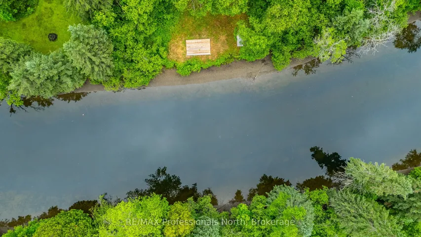
+"PublicRemarks": "Welcome to your next adventure! This level .33 acre lot is perfectly positioned on the serene Gull River, just 2 minutes to downtown Minden by car or a scenic 10 minute boat ride- ideal for ice cream runs, shopping, lunch visits or enjoying the charm of town from the river. The cleared lot offers an incredible opportunity to create your own waterfront getaway with a stationary deck at the waters edge and gentle slope, you will find a natural sandy entry that drops off to deeper waters. The Gull River is celebrated for its crystal-clear waters & gentle currents, perfect for kayaking, canoeing, or floating peacefully downstream. With direct access to Gull Lake, your boating & fishing options expand into one of Ontario's most beloved lake systems. Come and discover Haliburton County's truly unique 4-season playground!"
+"CityRegion": "Lutterworth"
+"CountyOrParish": "Haliburton"
+"CreationDate": "2025-10-31T00:01:38.393924+00:00"
+"CrossStreet": "Highway #35- Spring Valley Road"
+"DirectionFaces": "North"
+"Directions": "Highway #35 to Spring Valley Road, Turn onto laneway at 1152/1154 markers, Follow laneway to 1154 turn left and follow to property- Sign on Property"
+"Disclosures": array:1 [
0 => "Easement"
]
+"Exclusions": "N/A"
+"ExpirationDate": "2026-03-01"
+"Inclusions": "N/A"
+"InteriorFeatures": "None"
+"RFTransactionType": "For Sale"
+"InternetEntireListingDisplayYN": true
+"ListAOR": "One Point Association of REALTORS"
+"ListingContractDate": "2025-10-30"
+"LotSizeSource": "Geo Warehouse"
+"MainOfficeKey": "549100"
+"MajorChangeTimestamp": "2025-10-30T23:54:23Z"
+"MlsStatus": "New"
+"OccupantType": "Vacant"
+"OriginalEntryTimestamp": "2025-10-30T23:54:23Z"
+"OriginalListPrice": 159000.0
+"OriginatingSystemID": "A00001796"
+"OriginatingSystemKey": "Draft3200392"
+"PhotosChangeTimestamp": "2025-10-30T23:54:23Z"
+"Sewer": "None"
+"ShowingRequirements": array:1 [
0 => "Showing System"
]
+"SignOnPropertyYN": true
+"SourceSystemID": "A00001796"
+"SourceSystemName": "Toronto Regional Real Estate Board"
+"StateOrProvince": "ON"
+"StreetName": "Spring Valley"
+"StreetNumber": "0"
+"StreetSuffix": "Road"
+"TaxAnnualAmount": "603.7"
+"TaxLegalDescription": "PT LT 1 CON 1 ANSON PT 2 19R2009; T/W H122792; MINDEN HILLS"
+"TaxYear": "2024"
+"TransactionBrokerCompensation": "2.5%"
+"TransactionType": "For Sale"
+"WaterBodyName": "Gull River"
+"WaterfrontFeatures": "River Front"
+"WaterfrontYN": true
+"DDFYN": true
+"Water": "None"
+"GasYNA": "No"
+"CableYNA": "No"
+"LotDepth": 143.0
+"LotWidth": 103.28
+"SewerYNA": "No"
+"WaterYNA": "No"
+"@odata.id": "https://api.realtyfeed.com/reso/odata/Property('X12494108')"
+"Shoreline": array:3 [
0 => "Mixed"
1 => "Sandy"
2 => "Deep"
]
+"WaterView": array:1 [
0 => "Direct"
]
+"SurveyType": "Unknown"
+"Waterfront": array:1 [
0 => "Direct"
]
+"DockingType": array:1 [
0 => "None"
]
+"ElectricYNA": "No"
+"HoldoverDays": 60
+"TelephoneYNA": "No"
+"WaterBodyType": "River"
+"provider_name": "TRREB"
+"ContractStatus": "Available"
+"HSTApplication": array:1 [
0 => "Included In"
]
+"PossessionType": "Flexible"
+"PriorMlsStatus": "Draft"
+"WaterFrontageFt": "31.4"
+"AccessToProperty": array:3 [
0 => "Private Road"
1 => "Year Round Municipal Road"
2 => "Year Round Private Road"
]
+"AlternativePower": array:1 [
0 => "None"
]
+"LotSizeAreaUnits": "Acres"
+"LotSizeRangeAcres": "< .50"
+"PossessionDetails": "Flexible"
+"ShorelineAllowance": "Not Owned"
+"SpecialDesignation": array:1 [
0 => "Unknown"
]
+"WaterfrontAccessory": array:1 [
0 => "Not Applicable"
]
+"MediaChangeTimestamp": "2025-10-30T23:54:23Z"
+"SystemModificationTimestamp": "2025-10-31T13:46:13.258825Z"
+"Media": array:23 [
0 => array:26 [ …26]
1 => array:26 [ …26]
2 => array:26 [ …26]
3 => array:26 [ …26]
4 => array:26 [ …26]
5 => array:26 [ …26]
6 => array:26 [ …26]
7 => array:26 [ …26]
8 => array:26 [ …26]
9 => array:26 [ …26]
10 => array:26 [ …26]
11 => array:26 [ …26]
12 => array:26 [ …26]
13 => array:26 [ …26]
14 => array:26 [ …26]
15 => array:26 [ …26]
16 => array:26 [ …26]
17 => array:26 [ …26]
18 => array:26 [ …26]
19 => array:26 [ …26]
20 => array:26 [ …26]
21 => array:26 [ …26]
22 => array:26 [ …26]
]
+"ID": "613940"
}
4 => Realtyna\MlsOnTheFly\Components\CloudPost\SubComponents\RFClient\SDK\RF\Entities\RFProperty {#14599
+post_id: "613147"
+post_author: 1
+"ListingKey": "X12494144"
+"ListingId": "X12494144"
+"PropertyType": "Residential"
+"PropertySubType": "Vacant Land"
+"StandardStatus": "Active"
+"ModificationTimestamp": "2025-10-31T00:26:05Z"
+"RFModificationTimestamp": "2025-11-07T16:19:27Z"
+"ListPrice": 225000.0
+"BathroomsTotalInteger": 0
+"BathroomsHalf": 0
+"BedroomsTotal": 0
+"LotSizeArea": 3.968
+"LivingArea": 0
+"BuildingAreaTotal": 0
+"City": "Gravenhurst"
+"PostalCode": "P1P 1R3"
+"UnparsedAddress": "1036 Hopkins Road, Gravenhurst, ON P1P 1R3"
+"Coordinates": array:2 [
0 => -79.373131
1 => 44.91741
]
+"Latitude": 44.91741
+"Longitude": -79.373131
+"YearBuilt": 0
+"InternetAddressDisplayYN": true
+"FeedTypes": "IDX"
+"ListOfficeName": "CENTURY 21 B.J. ROTH REALTY LTD."
+"OriginatingSystemName": "TRREB"
+"PublicRemarks": "Discover this beautifully wooded 3.9-acre building lot, ideally situated halfway between Washago and Gravenhurst. Tucked away in a serene natural setting, this private property offers the peace and tranquility of country living.Towering trees and gentle terrain provide the ideal backdrop for your dream home or cottage retreat. With nearly four acres of mature forest, you'll enjoy endless privacy, fresh Muskoka air, and the sounds of nature all around you. Whether you envision a year-round residence or a seasonal escape, this property offers incredible potential and a location that connects you effortlessly to the best of Muskoka and Simcoe County.Build your future here-where quiet living, natural beauty, meet in perfect harmony."
+"CityRegion": "Ryde"
+"Country": "CA"
+"CountyOrParish": "Muskoka"
+"CreationDate": "2025-10-31T00:13:34.644520+00:00"
+"CrossStreet": "BARKWAY RD, MERKLEY RD, HOPKINS RD"
+"DirectionFaces": "West"
+"Directions": "MERKLEY RD TO HOPKINS RD"
+"ExpirationDate": "2026-01-31"
+"RFTransactionType": "For Sale"
+"InternetEntireListingDisplayYN": true
+"ListAOR": "Toronto Regional Real Estate Board"
+"ListingContractDate": "2025-10-27"
+"LotSizeSource": "Geo Warehouse"
+"MainOfficeKey": "074700"
+"MajorChangeTimestamp": "2025-10-31T00:10:19Z"
+"MlsStatus": "New"
+"OccupantType": "Vacant"
+"OriginalEntryTimestamp": "2025-10-31T00:10:19Z"
+"OriginalListPrice": 225000.0
+"OriginatingSystemID": "A00001796"
+"OriginatingSystemKey": "Draft3184624"
+"ParcelNumber": "480500217"
+"PhotosChangeTimestamp": "2025-10-31T00:10:19Z"
+"ShowingRequirements": array:2 [
0 => "Go Direct"
1 => "Showing System"
]
+"SignOnPropertyYN": true
+"SourceSystemID": "A00001796"
+"SourceSystemName": "Toronto Regional Real Estate Board"
+"StateOrProvince": "ON"
+"StreetName": "HOPKINS"
+"StreetNumber": "1036"
+"StreetSuffix": "Road"
+"TaxAnnualAmount": "305.09"
+"TaxLegalDescription": "PT LT 11 CON 10 RYDE PT 1 - 3 35R22247; S/T EASEMENT OVER PT 2 35R22247 AS IN MT6502; GRAVENHURST; THE DISTRICT MUNICIPALITY OF MUSKOKA"
+"TaxYear": "2025"
+"Topography": array:1 [
0 => "Wooded/Treed"
]
+"TransactionBrokerCompensation": "2.5%"
+"TransactionType": "For Sale"
+"View": array:1 [
0 => "Trees/Woods"
]
+"Zoning": "RR5"
+"DDFYN": true
+"GasYNA": "No"
+"CableYNA": "No"
+"LotDepth": 530.77
+"LotShape": "Rectangular"
+"LotWidth": 327.6
+"SewerYNA": "No"
+"WaterYNA": "No"
+"@odata.id": "https://api.realtyfeed.com/reso/odata/Property('X12494144')"
+"RollNumber": "440204000506505"
+"SurveyType": "None"
+"Waterfront": array:1 [
0 => "None"
]
+"ElectricYNA": "Available"
+"HoldoverDays": 90
+"TelephoneYNA": "No"
+"ParcelNumber2": 480500203
+"provider_name": "TRREB"
+"ContractStatus": "Available"
+"HSTApplication": array:1 [
0 => "In Addition To"
]
+"PossessionDate": "2025-11-30"
+"PossessionType": "Immediate"
+"PriorMlsStatus": "Draft"
+"LotSizeAreaUnits": "Acres"
+"LotSizeRangeAcres": "2-4.99"
+"SpecialDesignation": array:1 [
0 => "Unknown"
]
+"ShowingAppointments": "please use showing system before walking the property"
+"MediaChangeTimestamp": "2025-10-31T00:10:19Z"
+"DevelopmentChargesPaid": array:1 [
0 => "No"
]
+"SystemModificationTimestamp": "2025-10-31T00:26:05.813348Z"
+"PermissionToContactListingBrokerToAdvertise": true
+"Media": array:19 [
0 => array:26 [ …26]
1 => array:26 [ …26]
2 => array:26 [ …26]
3 => array:26 [ …26]
4 => array:26 [ …26]
5 => array:26 [ …26]
6 => array:26 [ …26]
7 => array:26 [ …26]
8 => array:26 [ …26]
9 => array:26 [ …26]
10 => array:26 [ …26]
11 => array:26 [ …26]
12 => array:26 [ …26]
13 => array:26 [ …26]
14 => array:26 [ …26]
15 => array:26 [ …26]
16 => array:26 [ …26]
17 => array:26 [ …26]
18 => array:26 [ …26]
]
+"ID": "613147"
}
5 => Realtyna\MlsOnTheFly\Components\CloudPost\SubComponents\RFClient\SDK\RF\Entities\RFProperty {#14607
+post_id: "559009"
+post_author: 1
+"ListingKey": "X12423460"
+"ListingId": "X12423460"
+"PropertyType": "Residential"
+"PropertySubType": "Vacant Land"
+"StandardStatus": "Active"
+"ModificationTimestamp": "2025-09-24T14:29:57Z"
+"RFModificationTimestamp": "2025-11-16T05:56:54Z"
+"ListPrice": 4995000.0
+"BathroomsTotalInteger": 0
+"BathroomsHalf": 0
+"BedroomsTotal": 0
+"LotSizeArea": 19.448
+"LivingArea": 0
+"BuildingAreaTotal": 0
+"City": "Lake Of Bays"
+"PostalCode": "L8H 6Z4"
+"UnparsedAddress": "2447 South Portage Road, Lake Of Bays, ON L8H 6Z4"
+"Coordinates": array:2 [
0 => -79.078948
1 => 45.267056
]
+"Latitude": 45.267056
+"Longitude": -79.078948
+"YearBuilt": 0
+"InternetAddressDisplayYN": true
+"FeedTypes": "IDX"
+"ListOfficeName": "Sotheby's International Realty Canada"
+"OriginatingSystemName": "TRREB"
+"PublicRemarks": "Experience the rare chance to own 19 acres of prime real estate with 628 feet of stunning waterfront on Lake of Bays. This exceptional property features breathtaking south-facing views and offers both sunrise and sunset vistas due to its unique topography. Easy to develop due to its very gentle slope and offers both shallow and deep water with a large beach. Great for all ages. Conveniently located just two hours from the Greater Toronto Area, you'll find easy access to the charming communities of Dwight, Huntsville, and Baysville. This property has not been for sale for over 100 years, making it a once-in-a-lifetime opportunity for discerning buyers. With many properties available, this gem stands out as a unique investment in natural beauty and accessibility. Don't miss your chance to own the best lot on Lake of Bays an opportunity like this comes once in a generation!"
+"CityRegion": "Franklin"
+"ConstructionMaterials": array:1 [
0 => "Log"
]
+"Country": "CA"
+"CountyOrParish": "Muskoka"
+"CreationDate": "2025-10-31T09:53:46.595704+00:00"
+"CrossStreet": "Brunel Rd. & South Portage Rd."
+"DirectionFaces": "South"
+"Directions": "Brunel Rd. to South Portage Rd."
+"Disclosures": array:2 [
0 => "Easement"
1 => "Right Of Way"
]
+"ExpirationDate": "2025-12-30"
+"FoundationDetails": array:1 [
0 => "Poured Concrete"
]
+"Inclusions": "all appliances in bunkie"
+"RFTransactionType": "For Sale"
+"InternetEntireListingDisplayYN": true
+"ListAOR": "One Point Association of REALTORS"
+"ListingContractDate": "2025-09-23"
+"LotSizeSource": "MPAC"
+"MainOfficeKey": "552800"
+"MajorChangeTimestamp": "2025-09-24T14:29:57Z"
+"MlsStatus": "New"
+"OccupantType": "Vacant"
+"OriginalEntryTimestamp": "2025-09-24T14:29:57Z"
+"OriginalListPrice": 4995000.0
+"OriginatingSystemID": "A00001796"
+"OriginatingSystemKey": "Draft3015126"
+"ParcelNumber": "480631005"
+"ParkingTotal": "10.0"
+"PhotosChangeTimestamp": "2025-09-24T14:29:57Z"
+"Roof": "Other"
+"Sewer": "Septic"
+"ShowingRequirements": array:1 [
0 => "Showing System"
]
+"SourceSystemID": "A00001796"
+"SourceSystemName": "Toronto Regional Real Estate Board"
+"StateOrProvince": "ON"
+"StreetName": "South Portage"
+"StreetNumber": "2447"
+"StreetSuffix": "Road"
+"TaxAnnualAmount": "12652.99"
+"TaxLegalDescription": "refer to Schedule D"
+"TaxYear": "2025"
+"TransactionBrokerCompensation": "2.5 + HST"
+"TransactionType": "For Sale"
+"View": array:4 [
0 => "Lake"
1 => "Trees/Woods"
2 => "Beach"
3 => "Forest"
]
+"WaterBodyName": "Lake of Bays"
+"WaterfrontFeatures": "Beach Front"
+"WaterfrontYN": true
+"DDFYN": true
+"Water": "Other"
+"GasYNA": "No"
+"CableYNA": "Yes"
+"LotShape": "Irregular"
+"LotWidth": 628.59
+"SewerYNA": "No"
+"WaterYNA": "No"
+"@odata.id": "https://api.realtyfeed.com/reso/odata/Property('X12423460')"
+"Shoreline": array:2 [
0 => "Clean"
1 => "Sandy"
]
+"WaterView": array:1 [
0 => "Direct"
]
+"GarageType": "None"
+"RollNumber": "442701000103201"
+"SurveyType": "Unknown"
+"Waterfront": array:1 [
0 => "Direct"
]
+"DockingType": array:1 [
0 => "None"
]
+"ElectricYNA": "Yes"
+"HoldoverDays": 90
+"TelephoneYNA": "Yes"
+"ParcelNumber2": 481000674
+"ParkingSpaces": 10
+"WaterBodyType": "Lake"
+"provider_name": "TRREB"
+"short_address": "Lake Of Bays, ON L8H 6Z4, CA"
+"AssessmentYear": 2024
+"ContractStatus": "Available"
+"HSTApplication": array:1 [
0 => "Not Subject to HST"
]
+"PossessionType": "Flexible"
+"PriorMlsStatus": "Draft"
+"LivingAreaRange": "< 700"
+"WaterFrontageFt": "191.59"
+"AccessToProperty": array:1 [
0 => "Municipal Road"
]
+"AlternativePower": array:1 [
0 => "None"
]
+"LotSizeAreaUnits": "Acres"
+"LotIrregularities": "2 parcels- refer to Schedule D"
+"LotSizeRangeAcres": "10-24.99"
+"PossessionDetails": "Flexible"
+"ShorelineExposure": "South"
+"ShorelineAllowance": "Owned"
+"SpecialDesignation": array:1 [
0 => "Unknown"
]
+"WaterfrontAccessory": array:1 [
0 => "Bunkie"
]
+"MediaChangeTimestamp": "2025-09-24T14:29:57Z"
+"SystemModificationTimestamp": "2025-10-21T23:39:28.622226Z"
+"PermissionToContactListingBrokerToAdvertise": true
+"Media": array:32 [
0 => array:26 [ …26]
1 => array:26 [ …26]
2 => array:26 [ …26]
3 => array:26 [ …26]
4 => array:26 [ …26]
5 => array:26 [ …26]
6 => array:26 [ …26]
7 => array:26 [ …26]
8 => array:26 [ …26]
9 => array:26 [ …26]
10 => array:26 [ …26]
11 => array:26 [ …26]
12 => array:26 [ …26]
13 => array:26 [ …26]
14 => array:26 [ …26]
15 => array:26 [ …26]
16 => array:26 [ …26]
17 => array:26 [ …26]
18 => array:26 [ …26]
19 => array:26 [ …26]
…12
]
+"ID": "559009"
}
6 => Realtyna\MlsOnTheFly\Components\CloudPost\SubComponents\RFClient\SDK\RF\Entities\RFProperty {#14434
+post_id: "635382"
+post_author: 1
+"ListingKey": "X12483657"
+"ListingId": "X12483657"
+"PropertyType": "Residential"
+"PropertySubType": "Vacant Land"
+"StandardStatus": "Active"
+"ModificationTimestamp": "2025-10-27T16:29:05Z"
+"RFModificationTimestamp": "2025-11-15T23:53:08Z"
+"ListPrice": 163900.0
+"BathroomsTotalInteger": 0
+"BathroomsHalf": 0
+"BedroomsTotal": 0
+"LotSizeArea": 0
+"LivingArea": 0
+"BuildingAreaTotal": 0
+"City": "Hawkesbury"
+"PostalCode": "K6A 1L9"
+"UnparsedAddress": "216 -218 Nelson Street E, Hawkesbury, ON K6A 1L9"
+"Coordinates": array:2 [ …2]
+"Latitude": 45.61104
+"Longitude": -74.6301772
+"YearBuilt": 0
+"InternetAddressDisplayYN": true
+"FeedTypes": "IDX"
+"ListOfficeName": "ROYAL LEPAGE PERFORMANCE REALTY"
+"OriginatingSystemName": "TRREB"
+"PublicRemarks": "Welcome to 216-218 Nelson Street in the town of Hawkesbury! This lot of 6,361.46 sq.ft. (0.146 ac), having a frontage of 47.15 feet by a depth of 134.55 feet, zoned R2 residential with municipal services (hydro & utilities) readily available on the street and is within walking distance to all amenities such as Main Street downtown, schools, library, sports complex, restaurants etc.. This would be an excellent opportunity to build an income property. Located midway between Montreal and Ottawa"
+"CityRegion": "612 - Hawkesbury"
+"Country": "CA"
+"CountyOrParish": "Prescott and Russell"
+"CreationDate": "2025-10-31T10:16:22.526227+00:00"
+"CrossStreet": "Mc Gill & Nelson"
+"DirectionFaces": "South"
+"Directions": "From Mc Gill Street going north turn right on Nelson Street."
+"ExpirationDate": "2026-03-31"
+"RFTransactionType": "For Sale"
+"InternetEntireListingDisplayYN": true
+"ListAOR": "Cornwall and District Real Estate Board"
+"ListingContractDate": "2025-10-25"
+"LotSizeSource": "Geo Warehouse"
+"MainOfficeKey": "479100"
+"MajorChangeTimestamp": "2025-10-27T15:47:55Z"
+"MlsStatus": "New"
+"OccupantType": "Vacant"
+"OriginalEntryTimestamp": "2025-10-27T15:47:55Z"
+"OriginalListPrice": 163900.0
+"OriginatingSystemID": "A00001796"
+"OriginatingSystemKey": "Draft3179912"
+"ParcelNumber": "541720068"
+"PhotosChangeTimestamp": "2025-10-27T15:47:56Z"
+"ShowingRequirements": array:1 [ …1]
+"SignOnPropertyYN": true
+"SourceSystemID": "A00001796"
+"SourceSystemName": "Toronto Regional Real Estate Board"
+"StateOrProvince": "ON"
+"StreetDirSuffix": "E"
+"StreetName": "Nelson"
+"StreetNumber": "216 -218"
+"StreetSuffix": "Street"
+"TaxAnnualAmount": "930.0"
+"TaxLegalDescription": "PCL 86-1 SEC M14; LT 86 PL M14 PLAN UNDER THE BOUNDARIES ACT PL BA-110 REGISTERED SEPT 1 1966 AS M-14 CONFIRMS THE TRUE LOCATION ON THE GROUND OF ALL BOUNDARIES OF THIS PCL; HAWKESBURY"
+"TaxYear": "2025"
+"TransactionBrokerCompensation": "2.5 %"
+"TransactionType": "For Sale"
+"Zoning": "R2"
+"DDFYN": true
+"GasYNA": "Available"
+"CableYNA": "Available"
+"LotDepth": 134.55
+"LotWidth": 47.15
+"SewerYNA": "Available"
+"WaterYNA": "Available"
+"@odata.id": "https://api.realtyfeed.com/reso/odata/Property('X12483657')"
+"RollNumber": "20805000103500"
+"SurveyType": "None"
+"Waterfront": array:1 [ …1]
+"ElectricYNA": "Available"
+"HoldoverDays": 30
+"TelephoneYNA": "Available"
+"provider_name": "TRREB"
+"short_address": "Hawkesbury, ON K6A 1L9, CA"
+"ContractStatus": "Available"
+"HSTApplication": array:1 [ …1]
+"PossessionType": "Immediate"
+"PriorMlsStatus": "Draft"
+"LotSizeRangeAcres": "Not Applicable"
+"PossessionDetails": "Immediate"
+"SpecialDesignation": array:1 [ …1]
+"MediaChangeTimestamp": "2025-10-27T15:47:56Z"
+"SystemModificationTimestamp": "2025-10-27T16:29:05.996982Z"
+"Media": array:7 [ …7]
+"ID": "635382"
}
7 => Realtyna\MlsOnTheFly\Components\CloudPost\SubComponents\RFClient\SDK\RF\Entities\RFProperty {#14601
+post_id: "605301"
+post_author: 1
+"ListingKey": "X12479171"
+"ListingId": "X12479171"
+"PropertyType": "Residential"
+"PropertySubType": "Vacant Land"
+"StandardStatus": "Active"
+"ModificationTimestamp": "2025-10-23T19:35:41Z"
+"RFModificationTimestamp": "2025-11-16T04:13:12Z"
+"ListPrice": 535000.0
+"BathroomsTotalInteger": 0
+"BathroomsHalf": 0
+"BedroomsTotal": 0
+"LotSizeArea": 0
+"LivingArea": 0
+"BuildingAreaTotal": 0
+"City": "Cavan Monaghan"
+"PostalCode": "L0A 1C0"
+"UnparsedAddress": "283 Bland Line, Cavan Monaghan, ON L0A 1C0"
+"Coordinates": array:2 [ …2]
+"Latitude": 44.246549227625
+"Longitude": -78.55341070944
+"YearBuilt": 0
+"InternetAddressDisplayYN": true
+"FeedTypes": "IDX"
+"ListOfficeName": "RE/MAX ALL-STARS REALTY INC."
+"OriginatingSystemName": "TRREB"
+"PublicRemarks": "Surreal 29.9 acres of vacant land offering plenty of privacy to build your dream home! Sets up well for someone looking to start their own homestead or just to be surrounded by nature. Mature trees throughout the property and magnificent views of the rolling hills in the countryside. Property fronts on Shields Dr. at the South East side of the lot & Bland Line on the North side entrance."
+"CityRegion": "Cavan Twp"
+"Country": "CA"
+"CountyOrParish": "Peterborough"
+"CreationDate": "2025-10-31T12:21:22.228828+00:00"
+"CrossStreet": "Sherbrooke St/Cty Rd 10"
+"DirectionFaces": "South"
+"Directions": "Sherbrooke St to County Rd. 10 to Bland Line"
+"ExpirationDate": "2026-01-28"
+"InteriorFeatures": "None"
+"RFTransactionType": "For Sale"
+"InternetEntireListingDisplayYN": true
+"ListAOR": "Central Lakes Association of REALTORS"
+"ListingContractDate": "2025-10-23"
+"MainOfficeKey": "142000"
+"MajorChangeTimestamp": "2025-10-23T19:35:41Z"
+"MlsStatus": "New"
+"OccupantType": "Vacant"
+"OriginalEntryTimestamp": "2025-10-23T19:35:41Z"
+"OriginalListPrice": 535000.0
+"OriginatingSystemID": "A00001796"
+"OriginatingSystemKey": "Draft3173402"
+"ParcelNumber": "280010330"
+"PhotosChangeTimestamp": "2025-10-23T19:35:41Z"
+"Sewer": "None"
+"ShowingRequirements": array:2 [ …2]
+"SourceSystemID": "A00001796"
+"SourceSystemName": "Toronto Regional Real Estate Board"
+"StateOrProvince": "ON"
+"StreetName": "Bland"
+"StreetNumber": "283"
+"StreetSuffix": "Line"
+"TaxAnnualAmount": "1448.0"
+"TaxAssessedValue": 112000
+"TaxLegalDescription": "PT LT 4, CON 13 CAVAN AS IN R626530 LT 23 RCP 111"
+"TaxYear": "2024"
+"TransactionBrokerCompensation": "2% + HST"
+"TransactionType": "For Sale"
+"Zoning": "RU"
+"DDFYN": true
+"Water": "None"
+"GasYNA": "No"
+"CableYNA": "No"
+"LotDepth": 1309.0
+"LotWidth": 69.3
+"SewerYNA": "No"
+"WaterYNA": "No"
+"@odata.id": "https://api.realtyfeed.com/reso/odata/Property('X12479171')"
+"SurveyType": "Unknown"
+"Waterfront": array:1 [ …1]
+"ElectricYNA": "Available"
+"HoldoverDays": 90
+"TelephoneYNA": "Available"
+"provider_name": "TRREB"
+"short_address": "Cavan Monaghan, ON L0A 1C0, CA"
+"AssessmentYear": 2024
+"ContractStatus": "Available"
+"HSTApplication": array:1 [ …1]
+"PossessionType": "Flexible"
+"PriorMlsStatus": "Draft"
+"LivingAreaRange": "< 700"
+"LotSizeRangeAcres": "25-49.99"
+"PossessionDetails": "TBD"
+"SpecialDesignation": array:1 [ …1]
+"MediaChangeTimestamp": "2025-10-23T19:35:41Z"
+"SystemModificationTimestamp": "2025-10-23T19:35:42.016333Z"
+"Media": array:15 [ …15]
+"ID": "605301"
}
8 => Realtyna\MlsOnTheFly\Components\CloudPost\SubComponents\RFClient\SDK\RF\Entities\RFProperty {#14602
+post_id: "616530"
+post_author: 1
+"ListingKey": "N12494736"
+"ListingId": "N12494736"
+"PropertyType": "Residential"
+"PropertySubType": "Vacant Land"
+"StandardStatus": "Active"
+"ModificationTimestamp": "2025-10-31T12:48:29Z"
+"RFModificationTimestamp": "2025-11-16T01:40:37Z"
+"ListPrice": 295000.0
+"BathroomsTotalInteger": 0
+"BathroomsHalf": 0
+"BedroomsTotal": 0
+"LotSizeArea": 0
+"LivingArea": 0
+"BuildingAreaTotal": 0
+"City": "Georgina"
+"PostalCode": "L0E 1N0"
+"UnparsedAddress": "Lot 11 Donna Drive, Georgina, ON L0E 1N0"
+"Coordinates": array:2 [ …2]
+"Latitude": 44.3368159
+"Longitude": -79.2288315
+"YearBuilt": 0
+"InternetAddressDisplayYN": true
+"FeedTypes": "IDX"
+"ListOfficeName": "EXP REALTY"
+"OriginatingSystemName": "TRREB"
+"PublicRemarks": "Amazing 75 x 218 Ft Vacant Lot Nestled On A Tranquil Street Surrounded By Charming Homes, Offering The Perfect Retreat From The Hustle And Bustle. Commuting Is A Breeze With A Short 20-Minute Drive To The Top Of Hwy 404 And Convenient Access To Hwy 48. Make This Your Peaceful Sanctuary In A Serene Neighbourhood. Enjoy A Variety Of Local Amenities, Including Parks, Stunning Sandy Beach, And Scenic Lake Simcoe With Year-Round Activities Such As Boating And Ice Fishing, Ideal For Outdoor Enthusiasts! Golf Lovers Will Appreciate The Proximity To Golf Courses. Additionally, Holmes Point Park & Beach And Sibbald Point Are Nearby Providing Relaxation And Recreation Opportunities Right At Your Doorstep."
+"CityRegion": "Pefferlaw"
+"CoListOfficeName": "EXP REALTY"
+"CoListOfficePhone": "866-530-7737"
+"CountyOrParish": "York"
+"CreationDate": "2025-10-31T12:53:15.369731+00:00"
+"CrossStreet": "Holmes Point Rd & Highway 48"
+"DirectionFaces": "South"
+"Directions": "Holmes Point Rd & Highway 48"
+"ExpirationDate": "2026-05-01"
+"InteriorFeatures": "None"
+"RFTransactionType": "For Sale"
+"InternetEntireListingDisplayYN": true
+"ListAOR": "Toronto Regional Real Estate Board"
+"ListingContractDate": "2025-10-31"
+"LotSizeSource": "MPAC"
+"MainOfficeKey": "285400"
+"MajorChangeTimestamp": "2025-10-31T12:48:29Z"
+"MlsStatus": "New"
+"OccupantType": "Vacant"
+"OriginalEntryTimestamp": "2025-10-31T12:48:29Z"
+"OriginalListPrice": 295000.0
+"OriginatingSystemID": "A00001796"
+"OriginatingSystemKey": "Draft3172406"
+"ParcelNumber": "35370030"
+"PhotosChangeTimestamp": "2025-10-31T12:48:29Z"
+"Sewer": "None"
+"ShowingRequirements": array:1 [ …1]
+"SignOnPropertyYN": true
+"SourceSystemID": "A00001796"
+"SourceSystemName": "Toronto Regional Real Estate Board"
+"StateOrProvince": "ON"
+"StreetName": "Donna"
+"StreetNumber": "Lot 11"
+"StreetSuffix": "Drive"
+"TaxAnnualAmount": "908.52"
+"TaxLegalDescription": "LOT 11 PLAN 520 GEORGINA T/W R355494 TOWN OF GEORGINA"
+"TaxYear": "2024"
+"TransactionBrokerCompensation": "2.5% + HST**"
+"TransactionType": "For Sale"
+"Zoning": "RU"
+"DDFYN": true
+"Water": "None"
+"GasYNA": "No"
+"CableYNA": "No"
+"LotDepth": 218.61
+"LotWidth": 75.0
+"SewerYNA": "No"
+"WaterYNA": "No"
+"@odata.id": "https://api.realtyfeed.com/reso/odata/Property('N12494736')"
+"RollNumber": "197000006257200"
+"SurveyType": "None"
+"Waterfront": array:1 [ …1]
+"ElectricYNA": "No"
+"HoldoverDays": 120
+"TelephoneYNA": "No"
+"provider_name": "TRREB"
+"short_address": "Georgina, ON L0E 1N0, CA"
+"ContractStatus": "Available"
+"HSTApplication": array:1 [ …1]
+"PossessionType": "Flexible"
+"PriorMlsStatus": "Draft"
+"MortgageComment": "Treat As Clear"
+"PropertyFeatures": array:5 [ …5]
+"LotSizeRangeAcres": "< .50"
+"PossessionDetails": "TBD"
+"SpecialDesignation": array:1 [ …1]
+"MediaChangeTimestamp": "2025-10-31T12:49:15Z"
+"SystemModificationTimestamp": "2025-10-31T12:49:15.342714Z"
+"PermissionToContactListingBrokerToAdvertise": true
+"Media": array:12 [ …12]
+"ID": "616530"
}
9 => Realtyna\MlsOnTheFly\Components\CloudPost\SubComponents\RFClient\SDK\RF\Entities\RFProperty {#14604
+post_id: "614603"
+post_author: 1
+"ListingKey": "X12495002"
+"ListingId": "X12495002"
+"PropertyType": "Residential"
+"PropertySubType": "Vacant Land"
+"StandardStatus": "Active"
+"ModificationTimestamp": "2025-10-31T13:31:38Z"
+"RFModificationTimestamp": "2025-11-15T23:53:09Z"
+"ListPrice": 799000.0
+"BathroomsTotalInteger": 0
+"BathroomsHalf": 0
+"BedroomsTotal": 0
+"LotSizeArea": 0
+"LivingArea": 0
+"BuildingAreaTotal": 0
+"City": "Blue Mountains"
+"PostalCode": "N0H 1J0"
+"UnparsedAddress": "106 Stone Zack Lane, Blue Mountains, ON N0H 1J0"
+"Coordinates": array:2 [ …2]
+"Latitude": 44.5302495
+"Longitude": -80.4008757
+"YearBuilt": 0
+"InternetAddressDisplayYN": true
+"FeedTypes": "IDX"
+"ListOfficeName": "Sotheby's International Realty Canada"
+"OriginatingSystemName": "TRREB"
+"PublicRemarks": "An exceptional opportunity awaits at 106 Stone Zack Lane, one of the few remaining building lots in the prestigious Georgian Bay Club community. Detailed architectural plans are available, allowing you to build immediately and create a custom luxury home in this sought-after enclave. This fully serviced lot offers a rare chance to craft a residence with a backyard facing the golf course, surrounded by elegant homes and breathtaking natural scenery. Perfectly positioned between Georgian Peaks Ski Club and Georgian Bay Club, this prime lot offers potential Georgian Bay views to the north and the stunning Niagara Escarpment to the south. Enjoy four-season living with easy access to Blue Mountain Resorts skiing, hiking, and outdoor adventures, as well as the charming town of Thornbury, known for boutique shopping, fine dining, and waterfront activities at Thornbury Harbour. This lot is part of Grey Common Elements Condominium Corporation No. 81, with a $225/month fee covering road maintenance, snow removal, lighting, landscaping, and reserve funds. All eligible development charges have been prepaid, with any remaining fees due only at the time of building permit application. HST is in addition to the purchase price. Architectural guidelines and subdivision covenants ensure a cohesive and upscale community aesthetic while allowing for a spectacular custom home or weekend retreat. With detailed plans in place, your dream home is closer than ever dont miss this rare chance to build in one of Ontarios most sought-after golf communities."
+"CityRegion": "Blue Mountains"
+"CoListOfficeName": "Sotheby's International Realty Canada"
+"CoListOfficePhone": "705-416-1499"
+"Country": "CA"
+"CountyOrParish": "Grey County"
+"CreationDate": "2025-10-31T13:42:15.418342+00:00"
+"CrossStreet": "Hwy 26; Camperdown"
+"DirectionFaces": "South"
+"Directions": "Hwy 26 to Camperdown Rd. to Stone Zack Lane."
+"Disclosures": array:1 [ …1]
+"ExpirationDate": "2026-04-30"
+"InteriorFeatures": "None"
+"RFTransactionType": "For Sale"
+"InternetEntireListingDisplayYN": true
+"ListAOR": "One Point Association of REALTORS"
+"ListingContractDate": "2025-10-31"
+"MainOfficeKey": "552800"
+"MajorChangeTimestamp": "2025-10-31T13:31:38Z"
+"MlsStatus": "New"
+"OccupantType": "Vacant"
+"OriginalEntryTimestamp": "2025-10-31T13:31:38Z"
+"OriginalListPrice": 799000.0
+"OriginatingSystemID": "A00001796"
+"OriginatingSystemKey": "Draft3203502"
+"PhotosChangeTimestamp": "2025-10-31T13:31:38Z"
+"Sewer": "None"
+"ShowingRequirements": array:3 [ …3]
+"SourceSystemID": "A00001796"
+"SourceSystemName": "Toronto Regional Real Estate Board"
+"StateOrProvince": "ON"
+"StreetName": "Stone Zack"
+"StreetNumber": "106"
+"StreetSuffix": "Lane"
+"TaxAnnualAmount": "1780.0"
+"TaxLegalDescription": "Unit 4, Level 1, Grey Vacant Land...see Schedule C under documents tab for complete legal description."
+"TaxYear": "2024"
+"TransactionBrokerCompensation": "2% Plus HST"
+"TransactionType": "For Sale"
+"VirtualTourURLUnbranded": "https://sites.elevatedphotos.ca/106stonezacklane?mls"
+"Zoning": "R1"
+"DDFYN": true
+"Water": "None"
+"GasYNA": "No"
+"Sewage": array:1 [ …1]
+"CableYNA": "No"
+"LotDepth": 145.5
+"LotWidth": 104.27
+"SewerYNA": "Yes"
+"WaterYNA": "Yes"
+"@odata.id": "https://api.realtyfeed.com/reso/odata/Property('X12495002')"
+"SurveyType": "Available"
+"Waterfront": array:1 [ …1]
+"ElectricYNA": "No"
+"HoldoverDays": 90
+"TelephoneYNA": "No"
+"provider_name": "TRREB"
+"short_address": "Blue Mountains, ON N0H 1J0, CA"
+"ContractStatus": "Available"
+"HSTApplication": array:1 [ …1]
+"PossessionType": "Immediate"
+"PriorMlsStatus": "Draft"
+"LivingAreaRange": "< 700"
+"PropertyFeatures": array:2 [ …2]
+"LotSizeRangeAcres": "< .50"
+"PossessionDetails": "Immediate"
+"SpecialDesignation": array:1 [ …1]
+"MediaChangeTimestamp": "2025-10-31T13:31:38Z"
+"SystemModificationTimestamp": "2025-10-31T13:31:38.686436Z"
+"Media": array:12 [ …12]
+"ID": "614603"
}
]
+success: true
+page_size: 10
+page_count: 297
+count: 2964
+after_key: ""
}
"RF Response Time" => "0.24 seconds"
]
]