array:2 [
"RF Cache Key: f05b717f809813e8b17371dc7cff4d49ea364bc1c7970484601b7c3da879124b" => array:1 [
"RF Cached Response" => Realtyna\MlsOnTheFly\Components\CloudPost\SubComponents\RFClient\SDK\RF\RFResponse {#14643
+items: array:10 [
0 => Realtyna\MlsOnTheFly\Components\CloudPost\SubComponents\RFClient\SDK\RF\Entities\RFProperty {#14400
+post_id: ? mixed
+post_author: ? mixed
+"ListingKey": "X12343948"
+"ListingId": "X12343948"
+"PropertyType": "Residential"
+"PropertySubType": "Vacant Land"
+"StandardStatus": "Active"
+"ModificationTimestamp": "2025-09-21T08:05:28Z"
+"RFModificationTimestamp": "2025-09-21T08:08:46Z"
+"ListPrice": 85000.0
+"BathroomsTotalInteger": 0
+"BathroomsHalf": 0
+"BedroomsTotal": 0
+"LotSizeArea": 1.079
+"LivingArea": 0
+"BuildingAreaTotal": 0
+"City": "Algonquin Highlands"
+"PostalCode": "K0M 1S0"
+"UnparsedAddress": "0 Barry Line Road, Algonquin Highlands, ON K0M 1S0"
+"Coordinates": array:2 [
0 => -78.8255515
1 => 45.2946735
]
+"Latitude": 45.2946735
+"Longitude": -78.8255515
+"YearBuilt": 0
+"InternetAddressDisplayYN": true
+"FeedTypes": "IDX"
+"ListOfficeName": "RE/MAX Professionals North"
+"OriginatingSystemName": "TRREB"
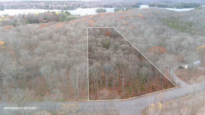
+"PublicRemarks": "Discover this level, just-over-1-acre building lot perfectly positioned at the corner of Barry Line Road and Cameron Lane. Barry Line Road is maintained year-round by the municipality, youll enjoy easy access in every season. Located only minutes from West Guilford, where youll find a convenient general store complete with an LCBO outlet, public beach and community center. Ten minutes from the Village of Haliburton, this property offers the ideal balance of rural tranquility and nearby conveniences. The sandy soil makes excavation a breeze, setting the stage for your dream home or cottage. A hydro easement runs through the property."
+"CityRegion": "Stanhope"
+"CoListOfficeName": "RE/MAX Professionals North"
+"CoListOfficePhone": "705-457-1011"
+"CountyOrParish": "Haliburton"
+"CreationDate": "2025-08-14T14:27:18.350701+00:00"
+"CrossStreet": "Highway 118"
+"DirectionFaces": "North"
+"Directions": "Highway 118 to Stanhope Airport Road to Barry Line Road"
+"Exclusions": "n/a"
+"ExpirationDate": "2025-12-15"
+"Inclusions": "n/a"
+"RFTransactionType": "For Sale"
+"InternetEntireListingDisplayYN": true
+"ListAOR": "One Point Association of REALTORS"
+"ListingContractDate": "2025-08-13"
+"LotSizeSource": "Geo Warehouse"
+"MainOfficeKey": "549100"
+"MajorChangeTimestamp": "2025-08-14T14:04:26Z"
+"MlsStatus": "New"
+"OccupantType": "Vacant"
+"OriginalEntryTimestamp": "2025-08-14T14:04:26Z"
+"OriginalListPrice": 85000.0
+"OriginatingSystemID": "A00001796"
+"OriginatingSystemKey": "Draft2843334"
+"ParcelNumber": "391320140"
+"PhotosChangeTimestamp": "2025-08-14T14:04:26Z"
+"ShowingRequirements": array:2 [
0 => "Go Direct"
1 => "Showing System"
]
+"SignOnPropertyYN": true
+"SourceSystemID": "A00001796"
+"SourceSystemName": "Toronto Regional Real Estate Board"
+"StateOrProvince": "ON"
+"StreetName": "Barry Line"
+"StreetNumber": "0"
+"StreetSuffix": "Road"
+"TaxAnnualAmount": "159.28"
+"TaxLegalDescription": "PT LT 30 CON 7 STANHOPE PT 2 & 3 19R7488; S/T H259356; S/T BENEFICIARIES INTEREST IN H257801; S/T RIGHT IN H144981; ALGONQUIN HIGHLANDS"
+"TaxYear": "2025"
+"TransactionBrokerCompensation": "2.5"
+"TransactionType": "For Sale"
+"Zoning": "RR"
+"DDFYN": true
+"GasYNA": "No"
+"CableYNA": "No"
+"LotShape": "Irregular"
+"LotWidth": 132.06
+"SewerYNA": "No"
+"WaterYNA": "No"
+"@odata.id": "https://api.realtyfeed.com/reso/odata/Property('X12343948')"
+"SurveyType": "Available"
+"Waterfront": array:1 [
0 => "None"
]
+"ElectricYNA": "Available"
+"HoldoverDays": 90
+"TelephoneYNA": "Available"
+"provider_name": "TRREB"
+"ContractStatus": "Available"
+"HSTApplication": array:1 [
0 => "Included In"
]
+"PossessionDate": "2025-09-30"
+"PossessionType": "Immediate"
+"PriorMlsStatus": "Draft"
+"LotSizeAreaUnits": "Acres"
+"LotSizeRangeAcres": ".50-1.99"
+"SpecialDesignation": array:1 [
0 => "Unknown"
]
+"MediaChangeTimestamp": "2025-08-14T14:04:26Z"
+"SystemModificationTimestamp": "2025-09-21T08:05:28.919958Z"
+"Media": array:11 [
0 => array:26 [
"Order" => 0
"ImageOf" => null
"MediaKey" => "f065be4b-41e2-4ab9-8ea6-6f2c30808183"
"MediaURL" => "https://cdn.realtyfeed.com/cdn/48/X12343948/006c25b23c6f70a4c249d15bdf7b1bc0.webp"
"ClassName" => "ResidentialFree"
"MediaHTML" => null
"MediaSize" => 2079255
"MediaType" => "webp"
"Thumbnail" => "https://cdn.realtyfeed.com/cdn/48/X12343948/thumbnail-006c25b23c6f70a4c249d15bdf7b1bc0.webp"
"ImageWidth" => 3840
"Permission" => array:1 [ …1]
"ImageHeight" => 2160
"MediaStatus" => "Active"
"ResourceName" => "Property"
"MediaCategory" => "Photo"
"MediaObjectID" => "f065be4b-41e2-4ab9-8ea6-6f2c30808183"
"SourceSystemID" => "A00001796"
"LongDescription" => null
"PreferredPhotoYN" => true
"ShortDescription" => null
"SourceSystemName" => "Toronto Regional Real Estate Board"
"ResourceRecordKey" => "X12343948"
"ImageSizeDescription" => "Largest"
"SourceSystemMediaKey" => "f065be4b-41e2-4ab9-8ea6-6f2c30808183"
"ModificationTimestamp" => "2025-08-14T14:04:26.226482Z"
"MediaModificationTimestamp" => "2025-08-14T14:04:26.226482Z"
]
1 => array:26 [
"Order" => 1
…25
]
2 => array:26 [ …26]
3 => array:26 [ …26]
4 => array:26 [ …26]
5 => array:26 [ …26]
6 => array:26 [ …26]
7 => array:26 [ …26]
8 => array:26 [ …26]
9 => array:26 [ …26]
10 => array:26 [ …26]
]
}
1 => Realtyna\MlsOnTheFly\Components\CloudPost\SubComponents\RFClient\SDK\RF\Entities\RFProperty {#14583
+post_id: ? mixed
+post_author: ? mixed
+"ListingKey": "X12343881"
+"ListingId": "X12343881"
+"PropertyType": "Residential"
+"PropertySubType": "Vacant Land"
+"StandardStatus": "Active"
+"ModificationTimestamp": "2025-09-21T08:03:46Z"
+"RFModificationTimestamp": "2025-09-21T08:08:46Z"
+"ListPrice": 299900.0
+"BathroomsTotalInteger": 0
+"BathroomsHalf": 0
+"BedroomsTotal": 0
+"LotSizeArea": 15.0
+"LivingArea": 0
+"BuildingAreaTotal": 0
+"City": "Stirling-rawdon"
+"PostalCode": "K0K 3E0"
+"UnparsedAddress": "878 Harold Road, Stirling-rawdon, ON K0K 3E0"
+"Coordinates": array:2 [
0 => -77.6483318
1 => 44.3656931
]
+"Latitude": 44.3656931
+"Longitude": -77.6483318
+"YearBuilt": 0
+"InternetAddressDisplayYN": true
+"FeedTypes": "IDX"
+"ListOfficeName": "ROYAL LEPAGE PROALLIANCE REALTY"
+"OriginatingSystemName": "TRREB"
+"PublicRemarks": "Discover a rare blend of beauty, privacy, and natural wonder on this 15-acre property tucked away on quiet Harold Road, just north of Stirling. Surrounded by open farm fields and forest this setting offers the kind of peace and tranquility that feels untouched by time. Wake up to breathtaking sunrises, unwind with glowing sunsets over rolling hills, and watch storms dance across the skyline. At night, the unspoiled darkness reveals a canopy of stars, perfect for stargazing. This is a place where nature sets the pace, and its beauty can't truly be scripted or captured, only experienced. A gravel driveway runs alongside the property, leading to a variety of outbuildings and possibilities for your vision. The 10' x 16' wired and insulated potting shed, with a wood-stove offers space for year-round gardening projects. A matching 10' x 16' storage shed houses solar equipment and an additional wood-stove. You'll also find an outhouse with a compostable toilet, a chicken coop, a goat barn with fencing, and established vegetable and herb gardens. The land has been organically maintained since 1979, with newly planted pine, hardwood, and fruit trees/bushes including apple, raspberry, mulberry, and elderberry. Winding trails, some cleared, some carved naturally by local wildlife like deer and coyotes, lead to multiple quiet sitting areas, each with its own unique view of the landscape. The original homestead still stands, now serving as storage, offering a nostalgic reminder of the property's history. For those who value privacy, natural beauty, and a connection to the land, this property offers a lifestyle that can't be replicated. Whether you dream of homesteading, building your ideal retreat, or simply living among nature, the possibilities here are as open as the horizon."
+"CityRegion": "Rawdon Ward"
+"CoListOfficeName": "ROYAL LEPAGE PROALLIANCE REALTY"
+"CoListOfficePhone": "613-966-6060"
+"CountyOrParish": "Hastings"
+"CreationDate": "2025-08-14T14:13:33.026993+00:00"
+"CrossStreet": "Harold Road and Highway 14"
+"DirectionFaces": "North"
+"Directions": "Highway 14 North from Stirling to Harold Road. West on Harold Road to 878 - Sign on property"
+"Disclosures": array:1 [
0 => "Unknown"
]
+"Exclusions": "Gazebo, Adirondack Chairs, Personal Belongings, All Lawn + Garden ornaments + Equipment, Firewood, Rainbarrels, Seacan, Welltiles on Driveway"
+"ExpirationDate": "2025-11-30"
+"Inclusions": "Solar System + Batteries, All Outbuildings, Burn Barrel"
+"RFTransactionType": "For Sale"
+"InternetEntireListingDisplayYN": true
+"ListAOR": "Central Lakes Association of REALTORS"
+"ListingContractDate": "2025-08-14"
+"LotSizeSource": "Geo Warehouse"
+"MainOfficeKey": "179000"
+"MajorChangeTimestamp": "2025-08-14T13:51:22Z"
+"MlsStatus": "New"
+"OccupantType": "Owner"
+"OriginalEntryTimestamp": "2025-08-14T13:51:22Z"
+"OriginalListPrice": 299900.0
+"OriginatingSystemID": "A00001796"
+"OriginatingSystemKey": "Draft2842880"
+"OtherStructures": array:3 [
0 => "Other"
1 => "Out Buildings"
2 => "Shed"
]
+"ParcelNumber": "403420188"
+"ParkingFeatures": array:1 [
0 => "Private"
]
+"ParkingTotal": "10.0"
+"PhotosChangeTimestamp": "2025-08-14T13:51:22Z"
+"PoolFeatures": array:1 [
0 => "None"
]
+"Sewer": array:1 [
0 => "None"
]
+"ShowingRequirements": array:2 [
0 => "Showing System"
1 => "List Salesperson"
]
+"SignOnPropertyYN": true
+"SourceSystemID": "A00001796"
+"SourceSystemName": "Toronto Regional Real Estate Board"
+"StateOrProvince": "ON"
+"StreetName": "Harold"
+"StreetNumber": "878"
+"StreetSuffix": "Road"
+"TaxAnnualAmount": "893.43"
+"TaxLegalDescription": "PART LOT 19, CONCESSION 8 RAWDON, PART 1 PLAN 21R25393 TOWNSHIP OF STIRLING RAWDON"
+"TaxYear": "2025"
+"Topography": array:3 [
0 => "Flat"
1 => "Rolling"
2 => "Wooded/Treed"
]
+"TransactionBrokerCompensation": "2.5% + HST"
+"TransactionType": "For Sale"
+"View": array:4 [
0 => "Hills"
1 => "Pasture"
2 => "Trees/Woods"
3 => "Valley"
]
+"WaterSource": array:1 [
0 => "None"
]
+"Zoning": "MA"
+"DDFYN": true
+"Water": "None"
+"GasYNA": "No"
+"Sewage": array:1 [
0 => "Privy"
]
+"CableYNA": "Available"
+"LotDepth": 1996.43
+"LotShape": "Irregular"
+"LotWidth": 330.0
+"SewerYNA": "No"
+"WaterYNA": "No"
+"@odata.id": "https://api.realtyfeed.com/reso/odata/Property('X12343881')"
+"GarageType": "None"
+"RollNumber": "122011902010702"
+"SurveyType": "Boundary Only"
+"Waterfront": array:1 [
0 => "None"
]
+"ElectricYNA": "Available"
+"HoldoverDays": 90
+"TelephoneYNA": "No"
+"ParkingSpaces": 10
+"provider_name": "TRREB"
+"ContractStatus": "Available"
+"HSTApplication": array:1 [
0 => "Included In"
]
+"PossessionType": "Flexible"
+"PriorMlsStatus": "Draft"
+"RuralUtilities": array:8 [
0 => "Cable Available"
1 => "Cell Services"
2 => "Electricity On Road"
3 => "Electricity To Lot Line"
4 => "Garbage Pickup"
5 => "Internet High Speed"
6 => "Off Grid"
7 => "Recycling Pickup"
]
+"AccessToProperty": array:1 [
0 => "Year Round Municipal Road"
]
+"AlternativePower": array:1 [
0 => "Solar Power"
]
+"LotSizeAreaUnits": "Acres"
+"PropertyFeatures": array:4 [
0 => "Part Cleared"
1 => "Rolling"
2 => "School Bus Route"
3 => "Wooded/Treed"
]
+"LotSizeRangeAcres": "10-24.99"
+"PossessionDetails": "FLEXIBLE"
+"SpecialDesignation": array:1 [
0 => "Unknown"
]
+"MediaChangeTimestamp": "2025-08-14T13:51:22Z"
+"SystemModificationTimestamp": "2025-09-21T08:03:46.374905Z"
+"Media": array:36 [
0 => array:26 [ …26]
1 => array:26 [ …26]
2 => array:26 [ …26]
3 => array:26 [ …26]
4 => array:26 [ …26]
5 => array:26 [ …26]
6 => array:26 [ …26]
7 => array:26 [ …26]
8 => array:26 [ …26]
9 => array:26 [ …26]
10 => array:26 [ …26]
11 => array:26 [ …26]
12 => array:26 [ …26]
13 => array:26 [ …26]
14 => array:26 [ …26]
15 => array:26 [ …26]
16 => array:26 [ …26]
17 => array:26 [ …26]
18 => array:26 [ …26]
19 => array:26 [ …26]
20 => array:26 [ …26]
21 => array:26 [ …26]
22 => array:26 [ …26]
23 => array:26 [ …26]
24 => array:26 [ …26]
25 => array:26 [ …26]
26 => array:26 [ …26]
27 => array:26 [ …26]
28 => array:26 [ …26]
29 => array:26 [ …26]
30 => array:26 [ …26]
31 => array:26 [ …26]
32 => array:26 [ …26]
33 => array:26 [ …26]
34 => array:26 [ …26]
35 => array:26 [ …26]
]
}
2 => Realtyna\MlsOnTheFly\Components\CloudPost\SubComponents\RFClient\SDK\RF\Entities\RFProperty {#14726
+post_id: ? mixed
+post_author: ? mixed
+"ListingKey": "X12343475"
+"ListingId": "X12343475"
+"PropertyType": "Residential"
+"PropertySubType": "Vacant Land"
+"StandardStatus": "Active"
+"ModificationTimestamp": "2025-09-21T07:54:37Z"
+"RFModificationTimestamp": "2025-09-21T07:57:03Z"
+"ListPrice": 329900.0
+"BathroomsTotalInteger": 0
+"BathroomsHalf": 0
+"BedroomsTotal": 0
+"LotSizeArea": 0
+"LivingArea": 0
+"BuildingAreaTotal": 0
+"City": "Lanark Highlands"
+"PostalCode": "K0G 1K0"
+"UnparsedAddress": "00 Triple Tower Road, Lanark Highlands, ON K0G 1K0"
+"Coordinates": array:2 [
0 => -76.4855983
1 => 45.0875524
]
+"Latitude": 45.0875524
+"Longitude": -76.4855983
+"YearBuilt": 0
+"InternetAddressDisplayYN": true
+"FeedTypes": "IDX"
+"ListOfficeName": "ROYAL LEPAGE TEAM REALTY"
+"OriginatingSystemName": "TRREB"
+"PublicRemarks": "Escape to 200 acres (more or less) of breathtaking Canadian wilderness, just a short distance from a township-maintained road. This property offers the perfect balance of natural beauty, outdoor adventure, and complete privacy. At its heart sits a rustic hunt camp equipped with propane lighting, making it the ideal base for your outdoor pursuits. The land is a diverse mix of hardwoods, softwoods, open hydro-line clearings, lowland meadows, and beaver ponds, creating a thriving habitat for large game, small game, and waterfowl. With the Hydro tower line and direct access to Crown Land, your recreational possibilities are endless. Whether you enjoy four-wheeling, snowmobiling, hiking, or hunting, you'll find countless trails nearby, including easy access to the K&P Trail system. In under 15 minutes, you can be at the Blueberry Mountain Hiking Trail, or spend your day fishing on Joes Lake, complete with a public boat launch, ball diamond, and lively community market events in the summer. The property is conveniently located 45 minutes to Perth or Carleton Place, 40 minutes to Almonte, and just 30 minutes to Calabogie, which offers year round fun with it's Ski Hill & Racetrack. A gate can easily be installed to create your own private retreat. Nature lovers will appreciate the striking Canadian Shield vein that runs through the land and the spectacular vista points offering panoramic views, especially in the fall when the highlands are ablaze with colour. Whether you dream of building your off-grid oasis or keeping it as a long-term recreational investment, this property delivers an unmatched connection to the land. Seize this rare opportunity to own a piece of Ontario's unspoiled wilderness where every season offers a new adventure."
+"CityRegion": "916 - Lanark Highlands (Lavant) Twp"
+"CoListOfficeName": "ROYAL LEPAGE TEAM REALTY"
+"CoListOfficePhone": "613-831-9287"
+"CountyOrParish": "Lanark"
+"CreationDate": "2025-08-14T10:37:55.801380+00:00"
+"CrossStreet": "Black Creek Road and Joes Lake Road"
+"DirectionFaces": "North"
+"Directions": "From Hopetown take HWY 511 north to French Line Road. Turn Left and follow for 10KM. Road turns into Black Creek Road. Make a right onto Joes Lake Road. Less than a KM up the road take a left to Triple Tower Road. Gate is at the end of the road."
+"ExpirationDate": "2026-07-31"
+"Inclusions": "Hunt Camp in 'As Is' Condition and all contents inside."
+"RFTransactionType": "For Sale"
+"InternetEntireListingDisplayYN": true
+"ListAOR": "Ottawa Real Estate Board"
+"ListingContractDate": "2025-08-14"
+"LotSizeSource": "Geo Warehouse"
+"MainOfficeKey": "506800"
+"MajorChangeTimestamp": "2025-08-14T10:34:36Z"
+"MlsStatus": "New"
+"OccupantType": "Vacant"
+"OriginalEntryTimestamp": "2025-08-14T10:34:36Z"
+"OriginalListPrice": 329900.0
+"OriginatingSystemID": "A00001796"
+"OriginatingSystemKey": "Draft2827530"
+"ParcelNumber": "050060023"
+"ParkingTotal": "15.0"
+"PhotosChangeTimestamp": "2025-08-14T10:34:36Z"
+"ShowingRequirements": array:3 [
0 => "Go Direct"
1 => "Lockbox"
2 => "Showing System"
]
+"SignOnPropertyYN": true
+"SourceSystemID": "A00001796"
+"SourceSystemName": "Toronto Regional Real Estate Board"
+"StateOrProvince": "ON"
+"StreetName": "Triple Tower"
+"StreetNumber": "00"
+"StreetSuffix": "Road"
+"TaxAnnualAmount": "541.15"
+"TaxLegalDescription": "PT LT 15 CON 5 LAVANT; PT LT 14 CON 5 LAVANT AS IN RS166616 ; S/T RN12075 TWP OF LANARK HIGHLANDS"
+"TaxYear": "2025"
+"Topography": array:3 [
0 => "Wooded/Treed"
1 => "Hilly"
2 => "Open Space"
]
+"TransactionBrokerCompensation": "2"
+"TransactionType": "For Sale"
+"View": array:4 [
0 => "Hills"
1 => "Meadow"
2 => "Trees/Woods"
3 => "Ridge"
]
+"DDFYN": true
+"GasYNA": "No"
+"CableYNA": "No"
+"LotDepth": 3998.26
+"LotShape": "Rectangular"
+"LotWidth": 2778.15
+"SewerYNA": "No"
+"WaterYNA": "No"
+"@odata.id": "https://api.realtyfeed.com/reso/odata/Property('X12343475')"
+"RollNumber": "94000101023500"
+"SurveyType": "Unknown"
+"Waterfront": array:1 [
0 => "None"
]
+"ElectricYNA": "No"
+"HoldoverDays": 90
+"TelephoneYNA": "No"
+"provider_name": "TRREB"
+"ContractStatus": "Available"
+"HSTApplication": array:1 [
0 => "In Addition To"
]
+"PossessionType": "Flexible"
+"PriorMlsStatus": "Draft"
+"PropertyFeatures": array:5 [
0 => "Wooded/Treed"
1 => "Skiing"
2 => "Rec./Commun.Centre"
3 => "Lake/Pond"
4 => "Beach"
]
+"LotSizeRangeAcres": "100 +"
+"PossessionDetails": "Flexible"
+"SpecialDesignation": array:1 [
0 => "Unknown"
]
+"MediaChangeTimestamp": "2025-08-14T10:34:36Z"
+"SystemModificationTimestamp": "2025-09-21T07:54:37.372492Z"
+"PermissionToContactListingBrokerToAdvertise": true
+"Media": array:21 [
0 => array:26 [ …26]
1 => array:26 [ …26]
2 => array:26 [ …26]
3 => array:26 [ …26]
4 => array:26 [ …26]
5 => array:26 [ …26]
6 => array:26 [ …26]
7 => array:26 [ …26]
8 => array:26 [ …26]
9 => array:26 [ …26]
10 => array:26 [ …26]
11 => array:26 [ …26]
12 => array:26 [ …26]
13 => array:26 [ …26]
14 => array:26 [ …26]
15 => array:26 [ …26]
16 => array:26 [ …26]
17 => array:26 [ …26]
18 => array:26 [ …26]
19 => array:26 [ …26]
20 => array:26 [ …26]
]
}
3 => Realtyna\MlsOnTheFly\Components\CloudPost\SubComponents\RFClient\SDK\RF\Entities\RFProperty {#14575
+post_id: ? mixed
+post_author: ? mixed
+"ListingKey": "X12342870"
+"ListingId": "X12342870"
+"PropertyType": "Residential"
+"PropertySubType": "Vacant Land"
+"StandardStatus": "Active"
+"ModificationTimestamp": "2025-09-21T07:45:15Z"
+"RFModificationTimestamp": "2025-09-21T07:49:19Z"
+"ListPrice": 475000.0
+"BathroomsTotalInteger": 0
+"BathroomsHalf": 0
+"BedroomsTotal": 0
+"LotSizeArea": 9041.4
+"LivingArea": 0
+"BuildingAreaTotal": 0
+"City": "Greely - Metcalfe - Osgoode - Vernon And Area"
+"PostalCode": "K4P 1H2"
+"UnparsedAddress": "6248 Nick Adams Road, Greely - Metcalfe - Osgoode - Vernon And Area, ON K4P 1H2"
+"Coordinates": array:2 [
0 => -75.59774
1 => 45.224143
]
+"Latitude": 45.224143
+"Longitude": -75.59774
+"YearBuilt": 0
+"InternetAddressDisplayYN": true
+"FeedTypes": "IDX"
+"ListOfficeName": "EXP REALTY"
+"OriginatingSystemName": "TRREB"
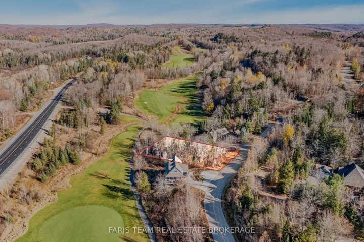
+"PublicRemarks": "Build Your Dream Home in the Prestigious Nick Adams Estates! Welcome to a rare opportunity in one of the areas most sought-after communities perfectly situated minutes from Manotick and Greely. This premium 2.235 acre lot boasts a generous 147.5 ft frontage and an impressive depth of over 660 ft, providing endless design possibilities for your future home. Surrounded by mature trees with no rear neighbors, enjoy peace, privacy, and the natural beauty of the countryside while remaining close to schools, golf courses, and recreation. The lot is well positioned for construction, well drilled and tested, septic approved, grading complete, with services accessible and infrastructure partially in place. Don't miss your chance to secure this exceptional property and make your dream home a reality!"
+"CityRegion": "1605 - Osgoode Twp North of Reg Rd 6"
+"CoListOfficeName": "EXP REALTY"
+"CoListOfficePhone": "613-733-9494"
+"Country": "CA"
+"CountyOrParish": "Ottawa"
+"CreationDate": "2025-08-13T20:36:28.250400+00:00"
+"CrossStreet": "Manotick Station Road"
+"DirectionFaces": "South"
+"Directions": "Mitch Owens to Manotick Station Road, Turn left on Nick Adams Road."
+"ExpirationDate": "2026-02-27"
+"RFTransactionType": "For Sale"
+"InternetEntireListingDisplayYN": true
+"ListAOR": "Ottawa Real Estate Board"
+"ListingContractDate": "2025-08-13"
+"LotSizeSource": "MPAC"
+"MainOfficeKey": "488700"
+"MajorChangeTimestamp": "2025-08-13T20:30:41Z"
+"MlsStatus": "New"
+"OccupantType": "Vacant"
+"OriginalEntryTimestamp": "2025-08-13T20:30:41Z"
+"OriginalListPrice": 475000.0
+"OriginatingSystemID": "A00001796"
+"OriginatingSystemKey": "Draft2835366"
+"ParcelNumber": "043181545"
+"PhotosChangeTimestamp": "2025-08-14T14:07:57Z"
+"ShowingRequirements": array:1 [
0 => "Showing System"
]
+"SignOnPropertyYN": true
+"SourceSystemID": "A00001796"
+"SourceSystemName": "Toronto Regional Real Estate Board"
+"StateOrProvince": "ON"
+"StreetName": "Nick Adams"
+"StreetNumber": "6248"
+"StreetSuffix": "Road"
+"TaxAnnualAmount": "1731.56"
+"TaxLegalDescription": "LOT 8, PLAN 4M1669 SUBJECT TO AN EASEMENT OVER PART 8 4R33256 AS IN OC2281143 SUBJECT TO AN EASEMENT IN GROSS OVER PART 8, 4R33256 AS IN OC2283059 CITY OF OTTAWA"
+"TaxYear": "2025"
+"TransactionBrokerCompensation": "2"
+"TransactionType": "For Sale"
+"DDFYN": true
+"GasYNA": "No"
+"CableYNA": "Available"
+"LotDepth": 200.92
+"LotWidth": 45.0
+"SewerYNA": "Yes"
+"WaterYNA": "No"
+"@odata.id": "https://api.realtyfeed.com/reso/odata/Property('X12342870')"
+"RollNumber": "61470003021554"
+"SurveyType": "Unknown"
+"Waterfront": array:1 [
0 => "None"
]
+"ElectricYNA": "Available"
+"HoldoverDays": 30
+"TelephoneYNA": "Available"
+"provider_name": "TRREB"
+"AssessmentYear": 2024
+"ContractStatus": "Available"
+"HSTApplication": array:1 [
0 => "In Addition To"
]
+"PossessionType": "Flexible"
+"PriorMlsStatus": "Draft"
+"LotSizeRangeAcres": "2-4.99"
+"PossessionDetails": "TBD"
+"SpecialDesignation": array:1 [
0 => "Unknown"
]
+"MediaChangeTimestamp": "2025-08-14T14:07:57Z"
+"SystemModificationTimestamp": "2025-09-21T07:45:15.720498Z"
+"PermissionToContactListingBrokerToAdvertise": true
+"Media": array:9 [
0 => array:26 [ …26]
1 => array:26 [ …26]
2 => array:26 [ …26]
3 => array:26 [ …26]
4 => array:26 [ …26]
5 => array:26 [ …26]
6 => array:26 [ …26]
7 => array:26 [ …26]
8 => array:26 [ …26]
]
}
4 => Realtyna\MlsOnTheFly\Components\CloudPost\SubComponents\RFClient\SDK\RF\Entities\RFProperty {#14723
+post_id: ? mixed
+post_author: ? mixed
+"ListingKey": "X12342567"
+"ListingId": "X12342567"
+"PropertyType": "Residential"
+"PropertySubType": "Vacant Land"
+"StandardStatus": "Active"
+"ModificationTimestamp": "2025-09-21T07:40:19Z"
+"RFModificationTimestamp": "2025-09-21T07:44:46Z"
+"ListPrice": 395000.0
+"BathroomsTotalInteger": 0
+"BathroomsHalf": 0
+"BedroomsTotal": 0
+"LotSizeArea": 0
+"LivingArea": 0
+"BuildingAreaTotal": 0
+"City": "Meaford"
+"PostalCode": "N4L 1W5"
+"UnparsedAddress": "108 Mc Kay Court, Meaford, ON N4L 1W5"
+"Coordinates": array:2 [
0 => -80.5916531
1 => 44.6069298
]
+"Latitude": 44.6069298
+"Longitude": -80.5916531
+"YearBuilt": 0
+"InternetAddressDisplayYN": true
+"FeedTypes": "IDX"
+"ListOfficeName": "Royal Le Page Locations North"
+"OriginatingSystemName": "TRREB"
+"PublicRemarks": "Stunning location with over 2 acres ready for your creative design masterpiece build. Located just a short drive from the town of Meaford, this parcel has a large 1 acre clearing ready for building. A long private driveway from Mc Kay Court offers this parcel amazing privacy and the feeling of being alone in the forest, yet it is just across the street from The Georgian Bay. The lot is accessed from Mc Kay court off of 7th Line. The cleared and open building plot is surrounded by mature trees and forest, with opportunity for any design home with a guest structure. Lake access is just minutes away via two options, ideal for enjoying The Georgian Bay in the summer. The ski hills at Blue Mountain are just 30 minutes away, making this an ideal four season location. Meaford offers great shopping and dining as well as a marina for the avid boaters."
+"CityRegion": "Meaford"
+"Country": "CA"
+"CountyOrParish": "Grey County"
+"CreationDate": "2025-08-13T19:06:45.907516+00:00"
+"CrossStreet": "7th Line"
+"DirectionFaces": "West"
+"Directions": "7th Line to Mc Kay Court to bottom of hill"
+"ExpirationDate": "2025-11-30"
+"RFTransactionType": "For Sale"
+"InternetEntireListingDisplayYN": true
+"ListAOR": "One Point Association of REALTORS"
+"ListingContractDate": "2025-08-13"
+"MainOfficeKey": "550100"
+"MajorChangeTimestamp": "2025-08-13T18:52:17Z"
+"MlsStatus": "New"
+"OccupantType": "Vacant"
+"OriginalEntryTimestamp": "2025-08-13T18:52:17Z"
+"OriginalListPrice": 395000.0
+"OriginatingSystemID": "A00001796"
+"OriginatingSystemKey": "Draft2849308"
+"PhotosChangeTimestamp": "2025-08-13T18:52:17Z"
+"Sewer": array:1 [
0 => "None"
]
+"ShowingRequirements": array:1 [
0 => "List Brokerage"
]
+"SignOnPropertyYN": true
+"SourceSystemID": "A00001796"
+"SourceSystemName": "Toronto Regional Real Estate Board"
+"StateOrProvince": "ON"
+"StreetName": "Mc Kay"
+"StreetNumber": "108"
+"StreetSuffix": "Court"
+"TaxAnnualAmount": "444.0"
+"TaxLegalDescription": "LT 8 PL 938; S/T RIGHT IN R419534; MEAFORD"
+"TaxYear": "2024"
+"TransactionBrokerCompensation": "2.5%"
+"TransactionType": "For Sale"
+"View": array:1 [
0 => "Trees/Woods"
]
+"VirtualTourURLBranded": "https://youtu.be/t-E_YPAFE9w"
+"VirtualTourURLUnbranded": "https://youtu.be/t-E_YPAFE9w"
+"Zoning": "ERB"
+"DDFYN": true
+"Water": "None"
+"GasYNA": "No"
+"CableYNA": "Available"
+"LotDepth": 419.0
+"LotWidth": 24.85
+"SewerYNA": "No"
+"WaterYNA": "No"
+"@odata.id": "https://api.realtyfeed.com/reso/odata/Property('X12342567')"
+"RollNumber": "421048000611809"
+"SurveyType": "None"
+"Waterfront": array:1 [
0 => "None"
]
+"ElectricYNA": "Yes"
+"HoldoverDays": 60
+"TelephoneYNA": "Available"
+"provider_name": "TRREB"
+"ContractStatus": "Available"
+"HSTApplication": array:1 [
0 => "Not Subject to HST"
]
+"PossessionType": "Flexible"
+"PriorMlsStatus": "Draft"
+"PropertyFeatures": array:6 [
0 => "Beach"
1 => "Cul de Sac/Dead End"
2 => "Lake Access"
3 => "Marina"
4 => "Part Cleared"
5 => "Skiing"
]
+"LotSizeRangeAcres": "2-4.99"
+"PossessionDetails": "Flexible"
+"SpecialDesignation": array:1 [
0 => "Unknown"
]
+"MediaChangeTimestamp": "2025-08-13T18:52:17Z"
+"SystemModificationTimestamp": "2025-09-21T07:40:19.445644Z"
+"PermissionToContactListingBrokerToAdvertise": true
+"Media": array:22 [
0 => array:26 [ …26]
1 => array:26 [ …26]
2 => array:26 [ …26]
3 => array:26 [ …26]
4 => array:26 [ …26]
5 => array:26 [ …26]
6 => array:26 [ …26]
7 => array:26 [ …26]
8 => array:26 [ …26]
9 => array:26 [ …26]
10 => array:26 [ …26]
11 => array:26 [ …26]
12 => array:26 [ …26]
13 => array:26 [ …26]
14 => array:26 [ …26]
15 => array:26 [ …26]
16 => array:26 [ …26]
17 => array:26 [ …26]
18 => array:26 [ …26]
19 => array:26 [ …26]
20 => array:26 [ …26]
21 => array:26 [ …26]
]
}
5 => Realtyna\MlsOnTheFly\Components\CloudPost\SubComponents\RFClient\SDK\RF\Entities\RFProperty {#14549
+post_id: ? mixed
+post_author: ? mixed
+"ListingKey": "X12342386"
+"ListingId": "X12342386"
+"PropertyType": "Residential"
+"PropertySubType": "Vacant Land"
+"StandardStatus": "Active"
+"ModificationTimestamp": "2025-09-21T07:36:29Z"
+"RFModificationTimestamp": "2025-09-21T07:41:38Z"
+"ListPrice": 269900.0
+"BathroomsTotalInteger": 0
+"BathroomsHalf": 0
+"BedroomsTotal": 0
+"LotSizeArea": 2.0
+"LivingArea": 0
+"BuildingAreaTotal": 0
+"City": "Mc Nab/braeside"
+"PostalCode": "K7S 1J1"
+"UnparsedAddress": "115 Poole Street, Mcnab/braeside, ON K7S 1J1"
+"Coordinates": array:2 [
0 => -76.37207
1 => 45.4412725
]
+"Latitude": 45.4412725
+"Longitude": -76.37207
+"YearBuilt": 0
+"InternetAddressDisplayYN": true
+"FeedTypes": "IDX"
+"ListOfficeName": "COLDWELL BANKER SARAZEN REALTY"
+"OriginatingSystemName": "TRREB"
+"PublicRemarks": "ENJOY THE PRIVACY YOU WILL HAVE ON THIS RARE 2.19 ACRE LOT ON THE EDGE OF ARNPRIOR BACKING ONTO THE ALGONQUIN TRAIL.THE LOT IS L SHAPED WITH 100' FRONTAGE ON POOLE ST AND APPROX. 361' ON THE EASTERN BORDER.BUILD YOUR DREAM HOME WITHIN WALKING DISTANCE OF ARNPRIOR AND THE HISTORIC GILLIES GROVE.SKIDOO AND HIKE FROM YOUR BACK DOOR.THIS PROPERTY WOULD LEND ITSELF TO 2 UNITS OR AN INLAW SUIT BUILT ON THE END PROVIDED MCNAB TWP.BUILDING LAWS ARE ADHERED TO.POOLE ST IS A PAVED ACCESS ROAD WITH HYDRO,BELL,CABLE AND NATURAL GAS."
+"CityRegion": "551 - Mcnab/Braeside Twps"
+"Country": "CA"
+"CountyOrParish": "Renfrew"
+"CreationDate": "2025-08-13T17:59:10.448356+00:00"
+"CrossStreet": "DIVISION"
+"DirectionFaces": "North"
+"Directions": "ELGIN ST WEST IN ARNPRIOR TO DIVISION ST.LEFT ON DIVISION THEN RIGHT ON POOLE ST."
+"ExpirationDate": "2025-12-31"
+"RFTransactionType": "For Sale"
+"InternetEntireListingDisplayYN": true
+"ListAOR": "Ottawa Real Estate Board"
+"ListingContractDate": "2025-08-13"
+"LotSizeSource": "MPAC"
+"MainOfficeKey": "484800"
+"MajorChangeTimestamp": "2025-08-13T17:56:11Z"
+"MlsStatus": "New"
+"OccupantType": "Vacant"
+"OriginalEntryTimestamp": "2025-08-13T17:56:11Z"
+"OriginalListPrice": 269900.0
+"OriginatingSystemID": "A00001796"
+"OriginatingSystemKey": "Draft2842474"
+"ParcelNumber": "573240329"
+"PhotosChangeTimestamp": "2025-08-14T15:54:47Z"
+"ShowingRequirements": array:1 [
0 => "Showing System"
]
+"SignOnPropertyYN": true
+"SourceSystemID": "A00001796"
+"SourceSystemName": "Toronto Regional Real Estate Board"
+"StateOrProvince": "ON"
+"StreetName": "Poole"
+"StreetNumber": "115"
+"StreetSuffix": "Street"
+"TaxAnnualAmount": "1075.0"
+"TaxLegalDescription": "LOT 26,PLAN 23,PT OF LOTS 28,30 AND 32 ON RP80361 MCNAB"
+"TaxYear": "2025"
+"TransactionBrokerCompensation": "2"
+"TransactionType": "For Sale"
+"Zoning": "RESIDENTIAL"
+"DDFYN": true
+"GasYNA": "Available"
+"CableYNA": "Available"
+"LotDepth": 361.46
+"LotShape": "Irregular"
+"LotWidth": 100.0
+"SewerYNA": "No"
+"WaterYNA": "No"
+"@odata.id": "https://api.realtyfeed.com/reso/odata/Property('X12342386')"
+"RollNumber": "470100103516500"
+"SurveyType": "Unknown"
+"Waterfront": array:1 [
0 => "None"
]
+"ElectricYNA": "Available"
+"HoldoverDays": 30
+"TelephoneYNA": "Available"
+"provider_name": "TRREB"
+"AssessmentYear": 2025
+"ContractStatus": "Available"
+"HSTApplication": array:1 [
0 => "In Addition To"
]
+"PossessionType": "Immediate"
+"PriorMlsStatus": "Draft"
+"ParcelOfTiedLand": "No"
+"LotIrregularities": "L-SHAPED"
+"LotSizeRangeAcres": "2-4.99"
+"PossessionDetails": "IMMEDIATE"
+"SpecialDesignation": array:1 [
0 => "Unknown"
]
+"ShowingAppointments": "PLEASE BOOK THRU SHOWING TIME SHOW AND SELL"
+"MediaChangeTimestamp": "2025-08-14T15:54:47Z"
+"DevelopmentChargesPaid": array:1 [
0 => "No"
]
+"SystemModificationTimestamp": "2025-09-21T07:36:29.676442Z"
+"Media": array:9 [
0 => array:26 [ …26]
1 => array:26 [ …26]
2 => array:26 [ …26]
3 => array:26 [ …26]
4 => array:26 [ …26]
5 => array:26 [ …26]
6 => array:26 [ …26]
7 => array:26 [ …26]
8 => array:26 [ …26]
]
}
6 => Realtyna\MlsOnTheFly\Components\CloudPost\SubComponents\RFClient\SDK\RF\Entities\RFProperty {#14550
+post_id: ? mixed
+post_author: ? mixed
+"ListingKey": "X12342259"
+"ListingId": "X12342259"
+"PropertyType": "Residential"
+"PropertySubType": "Vacant Land"
+"StandardStatus": "Active"
+"ModificationTimestamp": "2025-09-21T07:33:16Z"
+"RFModificationTimestamp": "2025-09-21T07:37:43Z"
+"ListPrice": 369000.0
+"BathroomsTotalInteger": 0
+"BathroomsHalf": 0
+"BedroomsTotal": 0
+"LotSizeArea": 4.55
+"LivingArea": 0
+"BuildingAreaTotal": 0
+"City": "Seguin"
+"PostalCode": "P0C 1J0"
+"UnparsedAddress": "Lot 78 141 Highway, Seguin, ON P0C 1J0"
+"Coordinates": array:2 [
0 => -79.824262
1 => 45.2884039
]
+"Latitude": 45.2884039
+"Longitude": -79.824262
+"YearBuilt": 0
+"InternetAddressDisplayYN": true
+"FeedTypes": "IDX"
+"ListOfficeName": "Engel & Volkers Parry Sound"
+"OriginatingSystemName": "TRREB"
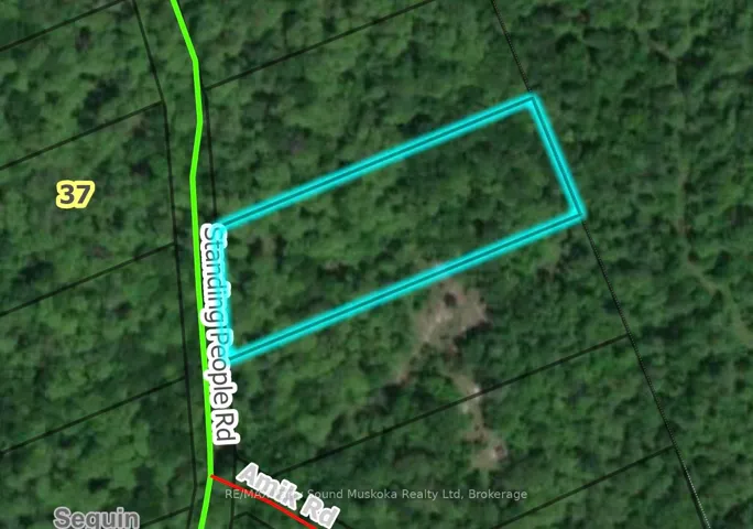
+"PublicRemarks": "Shadow River Riverfront Estate Lot | 4.55 Acres with 700' of Shoreline. Discover an extraordinary opportunity to craft your own Northern retreat on the tranquil shores of the Shadow River. This rare 4.55-acre estate lot offers an impressive 700 feet of private water frontage, set amidst a serene landscape of open meadow and scattered young hardwoods. Elevated well above the floodplain, the expansive 1.24-acre building envelope provides the ideal canvas for a grand main residence, extensive outdoor living spaces, and private amenities. Gently rolling and beautifully drained, the land invites elegant driveway approaches, manicured gardens, and sweeping river views. Enjoy peaceful paddles along the Shadow River or explore the nearby waters of Lake Rosseau, just minutes away. An MTO-approved driveway from Highway 141 ensures effortless year-round access, with the charming village of Rosseau only 5 minutes away, the Parry Sound Municipal Airport 20 minutes and Highway 400 just beyond. Unmatched in privacy, scale, and location, this is an opportunity perfect for those who dream of designing a riverfront estate that will be cherished for generations."
+"CityRegion": "Seguin"
+"Country": "CA"
+"CountyOrParish": "Parry Sound"
+"CreationDate": "2025-08-13T17:37:54.554797+00:00"
+"CrossStreet": "Nipissing & Hwy 141"
+"DirectionFaces": "North"
+"Directions": "Lake Joseph Road to Highway 141 - head east. Property on North Side. SOP."
+"Disclosures": array:1 [
0 => "Unknown"
]
+"ExpirationDate": "2025-12-31"
+"RFTransactionType": "For Sale"
+"InternetEntireListingDisplayYN": true
+"ListAOR": "One Point Association of REALTORS"
+"ListingContractDate": "2025-08-13"
+"LotSizeSource": "Survey"
+"MainOfficeKey": "575100"
+"MajorChangeTimestamp": "2025-08-13T17:18:27Z"
+"MlsStatus": "New"
+"OccupantType": "Vacant"
+"OriginalEntryTimestamp": "2025-08-13T17:18:27Z"
+"OriginalListPrice": 369000.0
+"OriginatingSystemID": "A00001796"
+"OriginatingSystemKey": "Draft2848048"
+"PhotosChangeTimestamp": "2025-08-13T17:18:27Z"
+"ShowingRequirements": array:1 [
0 => "Go Direct"
]
+"SignOnPropertyYN": true
+"SourceSystemID": "A00001796"
+"SourceSystemName": "Toronto Regional Real Estate Board"
+"StateOrProvince": "ON"
+"StreetName": "141"
+"StreetNumber": "Lot 78"
+"StreetSuffix": "Highway"
+"TaxLegalDescription": "Part of Lot 78, Concession B, Part of PIN 52199-0758(LT), Township of Humphrey, Now in the Township of Seguin, District of Parry Sound"
+"TaxYear": "2025"
+"TransactionBrokerCompensation": "2.5% + hst"
+"TransactionType": "For Sale"
+"VirtualTourURLBranded": "https://youtu.be/v WEWV9g RLNI"
+"WaterBodyName": "Shadow River"
+"WaterfrontFeatures": array:1 [
0 => "Not Applicable"
]
+"WaterfrontYN": true
+"Zoning": "RR & EP"
+"DDFYN": true
+"GasYNA": "No"
+"CableYNA": "No"
+"LotDepth": 763.45
+"LotWidth": 307.17
+"SewerYNA": "No"
+"WaterYNA": "No"
+"@odata.id": "https://api.realtyfeed.com/reso/odata/Property('X12342259')"
+"Shoreline": array:1 [
0 => "Natural"
]
+"WaterView": array:1 [
0 => "Direct"
]
+"SurveyType": "Available"
+"Waterfront": array:1 [
0 => "Direct"
]
+"DockingType": array:1 [
0 => "None"
]
+"ElectricYNA": "No"
+"HoldoverDays": 60
+"TelephoneYNA": "No"
+"WaterBodyType": "River"
+"provider_name": "TRREB"
+"ContractStatus": "Available"
+"HSTApplication": array:1 [
0 => "Included In"
]
+"PossessionType": "Immediate"
+"PriorMlsStatus": "Draft"
+"MortgageComment": "TAC"
+"AccessToProperty": array:2 [
0 => "Highway"
1 => "Public Road"
]
+"AlternativePower": array:1 [
0 => "None"
]
+"LotSizeAreaUnits": "Acres"
+"LotIrregularities": "Irregular"
+"LotSizeRangeAcres": "2-4.99"
+"PossessionDetails": "Immediate"
+"ShorelineAllowance": "None"
+"SpecialDesignation": array:1 [
0 => "Unknown"
]
+"WaterfrontAccessory": array:1 [
0 => "Not Applicable"
]
+"MediaChangeTimestamp": "2025-08-13T17:18:27Z"
+"SystemModificationTimestamp": "2025-09-21T07:33:16.446039Z"
+"Media": array:16 [
0 => array:26 [ …26]
1 => array:26 [ …26]
2 => array:26 [ …26]
3 => array:26 [ …26]
4 => array:26 [ …26]
5 => array:26 [ …26]
6 => array:26 [ …26]
7 => array:26 [ …26]
8 => array:26 [ …26]
9 => array:26 [ …26]
10 => array:26 [ …26]
11 => array:26 [ …26]
12 => array:26 [ …26]
13 => array:26 [ …26]
14 => array:26 [ …26]
15 => array:26 [ …26]
]
}
7 => Realtyna\MlsOnTheFly\Components\CloudPost\SubComponents\RFClient\SDK\RF\Entities\RFProperty {#14561
+post_id: ? mixed
+post_author: ? mixed
+"ListingKey": "X12342111"
+"ListingId": "X12342111"
+"PropertyType": "Residential"
+"PropertySubType": "Vacant Land"
+"StandardStatus": "Active"
+"ModificationTimestamp": "2025-09-21T07:30:45Z"
+"RFModificationTimestamp": "2025-09-21T07:33:40Z"
+"ListPrice": 800000.0
+"BathroomsTotalInteger": 0
+"BathroomsHalf": 0
+"BedroomsTotal": 0
+"LotSizeArea": 30.0
+"LivingArea": 0
+"BuildingAreaTotal": 0
+"City": "Grey Highlands"
+"PostalCode": "N0C 1C0"
+"UnparsedAddress": "448020 10th Concession, Grey Highlands, ON N0C 1C0"
+"Coordinates": array:2 [
0 => -80.4603896
1 => 44.3565469
]
+"Latitude": 44.3565469
+"Longitude": -80.4603896
+"YearBuilt": 0
+"InternetAddressDisplayYN": true
+"FeedTypes": "IDX"
+"ListOfficeName": "Royal Le Page RCR Realty"
+"OriginatingSystemName": "TRREB"
+"PublicRemarks": "30 acre corner property with 3 acre spring-fed pond near Feversham. Beautiful setting with driveway, well and former building site overlooking the pond. Hydro is available at the road. There are approximately 16 acres currently planted in corn and hardwood trees along the original fenceline. Located in an agricultural community 20 minutes from Collingwood. Great location for a custom home."
+"CityRegion": "Grey Highlands"
+"CoListOfficeName": "Royal Le Page RCR Realty"
+"CoListOfficePhone": "519-924-2950"
+"CountyOrParish": "Grey County"
+"CreationDate": "2025-08-13T16:35:27.292239+00:00"
+"CrossStreet": "10th Concession / SR 45"
+"DirectionFaces": "South"
+"Directions": "South East Corner of Sideroad 45 and 10th Concession"
+"ExpirationDate": "2026-02-09"
+"RFTransactionType": "For Sale"
+"InternetEntireListingDisplayYN": true
+"ListAOR": "One Point Association of REALTORS"
+"ListingContractDate": "2025-08-09"
+"MainOfficeKey": "571600"
+"MajorChangeTimestamp": "2025-08-13T16:32:50Z"
+"MlsStatus": "New"
+"OccupantType": "Vacant"
+"OriginalEntryTimestamp": "2025-08-13T16:32:50Z"
+"OriginalListPrice": 800000.0
+"OriginatingSystemID": "A00001796"
+"OriginatingSystemKey": "Draft2842430"
+"ParcelNumber": "372550356"
+"PhotosChangeTimestamp": "2025-08-14T18:29:08Z"
+"ShowingRequirements": array:1 [
0 => "Go Direct"
]
+"SignOnPropertyYN": true
+"SourceSystemID": "A00001796"
+"SourceSystemName": "Toronto Regional Real Estate Board"
+"StateOrProvince": "ON"
+"StreetName": "10th"
+"StreetNumber": "448020"
+"StreetSuffix": "Concession"
+"TaxAnnualAmount": "2415.66"
+"TaxAssessedValue": 171000
+"TaxLegalDescription": "Part Lot 11 Concession 10 as in GS65446 (Osprey) Municipality of Grey Highlands, County of Grey"
+"TaxYear": "2025"
+"TransactionBrokerCompensation": "2.0% +HST *See Remarks"
+"TransactionType": "For Sale"
+"Zoning": "A1, H"
+"DDFYN": true
+"Water": "Well"
+"GasYNA": "No"
+"CableYNA": "No"
+"LotDepth": 1552.0
+"LotWidth": 845.0
+"SewerYNA": "No"
+"WaterYNA": "No"
+"@odata.id": "https://api.realtyfeed.com/reso/odata/Property('X12342111')"
+"RollNumber": "420814000605310"
+"SurveyType": "None"
+"Waterfront": array:1 [
0 => "None"
]
+"ElectricYNA": "Available"
+"TelephoneYNA": "Available"
+"provider_name": "TRREB"
+"AssessmentYear": 2025
+"ContractStatus": "Available"
+"HSTApplication": array:1 [
0 => "Not Subject to HST"
]
+"PossessionType": "Immediate"
+"PriorMlsStatus": "Draft"
+"LotSizeAreaUnits": "Acres"
+"PropertyFeatures": array:1 [
0 => "Lake/Pond"
]
+"LotSizeRangeAcres": "25-49.99"
+"PossessionDetails": "Flexible"
+"SpecialDesignation": array:1 [
0 => "Unknown"
]
+"MediaChangeTimestamp": "2025-08-14T18:29:08Z"
+"SystemModificationTimestamp": "2025-09-21T07:30:45.632159Z"
+"Media": array:8 [
0 => array:26 [ …26]
1 => array:26 [ …26]
2 => array:26 [ …26]
3 => array:26 [ …26]
4 => array:26 [ …26]
5 => array:26 [ …26]
6 => array:26 [ …26]
7 => array:26 [ …26]
]
}
8 => Realtyna\MlsOnTheFly\Components\CloudPost\SubComponents\RFClient\SDK\RF\Entities\RFProperty {#14562
+post_id: ? mixed
+post_author: ? mixed
+"ListingKey": "X12341820"
+"ListingId": "X12341820"
+"PropertyType": "Residential"
+"PropertySubType": "Vacant Land"
+"StandardStatus": "Active"
+"ModificationTimestamp": "2025-09-21T07:25:07Z"
+"RFModificationTimestamp": "2025-09-21T07:29:07Z"
+"ListPrice": 369000.0
+"BathroomsTotalInteger": 0
+"BathroomsHalf": 0
+"BedroomsTotal": 0
+"LotSizeArea": 1.097
+"LivingArea": 0
+"BuildingAreaTotal": 0
+"City": "Fort Erie"
+"PostalCode": "L0S 1N0"
+"UnparsedAddress": "Part B - 345 Stonemill Road, Fort Erie, ON L0S 1N0"
+"Coordinates": array:2 [
0 => -78.918611
1 => 42.91308
]
+"Latitude": 42.91308
+"Longitude": -78.918611
+"YearBuilt": 0
+"InternetAddressDisplayYN": true
+"FeedTypes": "IDX"
+"ListOfficeName": "ROYAL LEPAGE NRC REALTY"
+"OriginatingSystemName": "TRREB"
+"PublicRemarks": "Heres your chance to build your dreamhome on a one of a kind 1.097 acre lot on Stonemill Road in Fort Erie! This lot has 150.92 feet of Frontage and a depth of 310 feet! The lots south side runs 310 feet down the friendship trail, and is directly beside Windmill point! At the end of the road is the Stonemill waterfront window, which provides sand beach access. Quick access to garrison road for all your amenities, and quick access to ridgeway downtown and crystal beach! Bring your vision!"
+"CityRegion": "335 - Ridgeway"
+"CountyOrParish": "Niagara"
+"CreationDate": "2025-08-13T15:36:00.836152+00:00"
+"CrossStreet": "Dominion/Stonemill"
+"DirectionFaces": "West"
+"Directions": "Dominion to Stonemill towards lake"
+"ExpirationDate": "2026-05-31"
+"RFTransactionType": "For Sale"
+"InternetEntireListingDisplayYN": true
+"ListAOR": "Niagara Association of REALTORS"
+"ListingContractDate": "2025-08-13"
+"MainOfficeKey": "292600"
+"MajorChangeTimestamp": "2025-08-13T15:24:58Z"
+"MlsStatus": "New"
+"OccupantType": "Vacant"
+"OriginalEntryTimestamp": "2025-08-13T15:24:58Z"
+"OriginalListPrice": 369000.0
+"OriginatingSystemID": "A00001796"
+"OriginatingSystemKey": "Draft2795774"
+"PhotosChangeTimestamp": "2025-08-13T15:24:58Z"
+"ShowingRequirements": array:1 [
0 => "Go Direct"
]
+"SignOnPropertyYN": true
+"SourceSystemID": "A00001796"
+"SourceSystemName": "Toronto Regional Real Estate Board"
+"StateOrProvince": "ON"
+"StreetName": "Stonemill"
+"StreetNumber": "Part B - 345"
+"StreetSuffix": "Road"
+"TaxLegalDescription": "PT LT 13 CON 1 LAKE ERIE BERTIE AS IN RO87308 & BE46539 EXCEPT RO163246, RO156402 & RO157789; S/T BE45757; FORT ERIE"
+"TaxYear": "2025"
+"TransactionBrokerCompensation": "2% plus hst"
+"TransactionType": "For Sale"
+"DDFYN": true
+"GasYNA": "Available"
+"CableYNA": "Available"
+"LotDepth": 94.5
+"LotWidth": 46.0
+"SewerYNA": "No"
+"WaterYNA": "No"
+"@odata.id": "https://api.realtyfeed.com/reso/odata/Property('X12341820')"
+"SurveyType": "Available"
+"Waterfront": array:1 [
0 => "Indirect"
]
+"ElectricYNA": "Available"
+"HoldoverDays": 30
+"TelephoneYNA": "Available"
+"provider_name": "TRREB"
+"ContractStatus": "Available"
+"HSTApplication": array:1 [
0 => "Included In"
]
+"PossessionType": "Flexible"
+"PriorMlsStatus": "Draft"
+"LotSizeAreaUnits": "Acres"
+"LotSizeRangeAcres": ".50-1.99"
+"PossessionDetails": "asap"
+"SpecialDesignation": array:1 [
0 => "Unknown"
]
+"MediaChangeTimestamp": "2025-08-18T18:30:11Z"
+"SystemModificationTimestamp": "2025-09-21T07:25:07.739582Z"
+"PermissionToContactListingBrokerToAdvertise": true
+"Media": array:5 [
0 => array:26 [ …26]
1 => array:26 [ …26]
2 => array:26 [ …26]
3 => array:26 [ …26]
4 => array:26 [ …26]
]
}
9 => Realtyna\MlsOnTheFly\Components\CloudPost\SubComponents\RFClient\SDK\RF\Entities\RFProperty {#14563
+post_id: ? mixed
+post_author: ? mixed
+"ListingKey": "X12341713"
+"ListingId": "X12341713"
+"PropertyType": "Residential"
+"PropertySubType": "Vacant Land"
+"StandardStatus": "Active"
+"ModificationTimestamp": "2025-09-21T07:22:54Z"
+"RFModificationTimestamp": "2025-09-21T07:25:40Z"
+"ListPrice": 60000.0
+"BathroomsTotalInteger": 0
+"BathroomsHalf": 0
+"BedroomsTotal": 0
+"LotSizeArea": 1.28
+"LivingArea": 0
+"BuildingAreaTotal": 0
+"City": "Russell"
+"PostalCode": "K4R 1E5"
+"UnparsedAddress": "00 North Russell Road, Russell, ON K4R 1E5"
+"Coordinates": array:2 [
0 => -75.393098
1 => 45.3204297
]
+"Latitude": 45.3204297
+"Longitude": -75.393098
+"YearBuilt": 0
+"InternetAddressDisplayYN": true
+"FeedTypes": "IDX"
+"ListOfficeName": "EXP REALTY"
+"OriginatingSystemName": "TRREB"
+"PublicRemarks": "Unique 1.28-Acre Parcel Just North of Russell. Discover the perfect blend of rural charm and convenience with this unique 1.28-acre parcel located just minutes north of the Village of Russell. Zoned A2 (see attachment for permitted uses), this property offers incredible potential for your vision whether you're looking to build a home, or explore other opportunities. Enjoy expansive, views of surrounding farmland, offering a peaceful setting and plenty of open space. The propertys location provides easy access to local amenities, schools, and community events while allowing you to embrace the quiet beauty of country living. Bring your ideas, roll up your sleeves, and make this special property your own."
+"CityRegion": "603 - Russell Twp"
+"Country": "CA"
+"CountyOrParish": "Prescott and Russell"
+"CreationDate": "2025-08-13T15:17:07.091562+00:00"
+"CrossStreet": "Burton Road and North Russell Road"
+"DirectionFaces": "North"
+"Directions": "Exit 417 @ Boundary Road, exit 96. Travel South on Boundary Road to Devine Road. Turn Left on Devine. Turn Right on Frontier Road. Property is located on the Left had side where the road curves and changes to North Russell Road."
+"ExpirationDate": "2025-12-12"
+"RFTransactionType": "For Sale"
+"InternetEntireListingDisplayYN": true
+"ListAOR": "Ottawa Real Estate Board"
+"ListingContractDate": "2025-08-12"
+"LotSizeSource": "Geo Warehouse"
+"MainOfficeKey": "488700"
+"MajorChangeTimestamp": "2025-09-11T15:40:50Z"
+"MlsStatus": "New"
+"OccupantType": "Vacant"
+"OriginalEntryTimestamp": "2025-08-13T15:02:57Z"
+"OriginalListPrice": 60000.0
+"OriginatingSystemID": "A00001796"
+"OriginatingSystemKey": "Draft2845492"
+"ParcelNumber": "690000047"
+"PhotosChangeTimestamp": "2025-08-13T15:02:58Z"
+"ShowingRequirements": array:2 [
0 => "Go Direct"
1 => "Showing System"
]
+"SignOnPropertyYN": true
+"SourceSystemID": "A00001796"
+"SourceSystemName": "Toronto Regional Real Estate Board"
+"StateOrProvince": "ON"
+"StreetName": "North Russell"
+"StreetNumber": "00"
+"StreetSuffix": "Road"
+"TaxAnnualAmount": "124.0"
+"TaxLegalDescription": "PT LT 23, CON 2 Russell PT 4, 50R2849; RUSSELL"
+"TaxYear": "2025"
+"Topography": array:1 [
0 => "Flat"
]
+"TransactionBrokerCompensation": "2.0"
+"TransactionType": "For Sale"
+"Zoning": "A2"
+"DDFYN": true
+"GasYNA": "No"
+"CableYNA": "Available"
+"LotDepth": 440.13
+"LotShape": "Irregular"
+"LotWidth": 484.32
+"SewerYNA": "No"
+"WaterYNA": "No"
+"@odata.id": "https://api.realtyfeed.com/reso/odata/Property('X12341713')"
+"RollNumber": "30600000207800"
+"SurveyType": "None"
+"Waterfront": array:1 [
0 => "None"
]
+"ElectricYNA": "Available"
+"HoldoverDays": 90
+"TelephoneYNA": "Available"
+"provider_name": "TRREB"
+"ContractStatus": "Available"
+"HSTApplication": array:1 [
0 => "In Addition To"
]
+"PossessionType": "Immediate"
+"PriorMlsStatus": "Sold Conditional"
+"LotSizeAreaUnits": "Acres"
+"LotSizeRangeAcres": ".50-1.99"
+"PossessionDetails": "Immediate"
+"SpecialDesignation": array:1 [
0 => "Unknown"
]
+"MediaChangeTimestamp": "2025-08-15T23:35:19Z"
+"DevelopmentChargesPaid": array:1 [
0 => "Unknown"
]
+"SystemModificationTimestamp": "2025-09-21T07:22:54.991431Z"
+"SoldConditionalEntryTimestamp": "2025-08-25T12:49:20Z"
+"PermissionToContactListingBrokerToAdvertise": true
+"Media": array:1 [
0 => array:26 [ …26]
]
}
]
+success: true
+page_size: 10
+page_count: 327
+count: 3269
+after_key: ""
}
]
"RF Query: /Property?$select=ALL&$orderby=meta_value date DESC&$top=10&$skip=2810&$filter=(StandardStatus eq 'Active') and PropertyType in ('Residential', 'Residential Income', 'Residential Lease') AND PropertySubType eq 'Vacant Land'/Property?$select=ALL&$orderby=meta_value date DESC&$top=10&$skip=2810&$filter=(StandardStatus eq 'Active') and PropertyType in ('Residential', 'Residential Income', 'Residential Lease') AND PropertySubType eq 'Vacant Land'&$expand=Media/Property?$select=ALL&$orderby=meta_value date DESC&$top=10&$skip=2810&$filter=(StandardStatus eq 'Active') and PropertyType in ('Residential', 'Residential Income', 'Residential Lease') AND PropertySubType eq 'Vacant Land'/Property?$select=ALL&$orderby=meta_value date DESC&$top=10&$skip=2810&$filter=(StandardStatus eq 'Active') and PropertyType in ('Residential', 'Residential Income', 'Residential Lease') AND PropertySubType eq 'Vacant Land'&$expand=Media&$count=true" => array:2 [
"RF Response" => Realtyna\MlsOnTheFly\Components\CloudPost\SubComponents\RFClient\SDK\RF\RFResponse {#14591
+items: array:10 [
0 => Realtyna\MlsOnTheFly\Components\CloudPost\SubComponents\RFClient\SDK\RF\Entities\RFProperty {#14602
+post_id: "223442"
+post_author: 1
+"ListingKey": "X12032791"
+"ListingId": "X12032791"
+"PropertyType": "Residential"
+"PropertySubType": "Vacant Land"
+"StandardStatus": "Active"
+"ModificationTimestamp": "2025-11-10T15:26:55Z"
+"RFModificationTimestamp": "2025-11-12T23:43:03Z"
+"ListPrice": 69990.0
+"BathroomsTotalInteger": 0
+"BathroomsHalf": 0
+"BedroomsTotal": 0
+"LotSizeArea": 0
+"LivingArea": 0
+"BuildingAreaTotal": 0
+"City": "Out Of Area"
+"PostalCode": "30157"
+"UnparsedAddress": "Lot 6 Shawnee Trail, Out Of Area, None 30157"
+"Coordinates": array:2 [
0 => -84.845524
1 => 33.903352
]
+"Latitude": 33.903352
+"Longitude": -84.845524
+"YearBuilt": 0
+"InternetAddressDisplayYN": true
+"FeedTypes": "IDX"
+"ListOfficeName": "CENTURY 21 HERITAGE GROUP LTD."
+"OriginatingSystemName": "TRREB"
+"PublicRemarks": "SELLER FINANCING AVAILABLE! BEAUTIFUL WELL TREED RESIDENTIAL ESTATE BUILDING LOT. EASY 25 MINUTES TO ATLANTA, GA. APPROX. 1/2 ACRE IN UPSCALE WYNCHESTER STATION SUBDIVISION. NEAR RECREATIONAL TRAILS, RETAIL, COMMERCIAL AND MEDICAL FACILITIES, PLUS MANY AREA AMENITIES. IDEAL FOR BUILDING YOUR DREAM HOME OR INVESTMENT. **ALL PRICES ARE IN US DOLLARS**"
+"CountyOrParish": "Other Country"
+"CreationDate": "2025-11-04T18:03:07.603586+00:00"
+"DirectionFaces": "South"
+"Directions": "Happy Valley Church Rd/Old Villa Rica Rd"
+"Exclusions": "N/A"
+"ExpirationDate": "2025-12-31"
+"Inclusions": "ALL FIXTURES"
+"InteriorFeatures": "None"
+"RFTransactionType": "For Sale"
+"InternetEntireListingDisplayYN": true
+"ListAOR": "Toronto Regional Real Estate Board"
+"ListingContractDate": "2025-03-20"
+"MainOfficeKey": "248500"
+"MajorChangeTimestamp": "2025-03-20T20:19:18Z"
+"MlsStatus": "New"
+"OccupantType": "Vacant"
+"OriginalEntryTimestamp": "2025-03-20T20:19:18Z"
+"OriginalListPrice": 69990.0
+"OriginatingSystemID": "A00001796"
+"OriginatingSystemKey": "Draft2115634"
+"PhotosChangeTimestamp": "2025-05-08T20:55:05Z"
+"Sewer": "None"
+"ShowingRequirements": array:1 [
0 => "List Salesperson"
]
+"SourceSystemID": "A00001796"
+"SourceSystemName": "Toronto Regional Real Estate Board"
+"StreetName": "Shawnee"
+"StreetNumber": "Lot 6"
+"StreetSuffix": "Trail"
+"TaxAnnualAmount": "298.5"
+"TaxLegalDescription": "LOT 6, LANDLOTS 445&492. 2ND Dist, 3rd Set, GA, USA"
+"TaxYear": "2024"
+"TransactionBrokerCompensation": "2.5%"
+"TransactionType": "For Sale"
+"DDFYN": true
+"Water": "Municipal"
+"GasYNA": "Available"
+"CableYNA": "Available"
+"LotWidth": 0.46
+"SewerYNA": "No"
+"WaterYNA": "Yes"
+"@odata.id": "https://api.realtyfeed.com/reso/odata/Property('X12032791')"
+"SurveyType": "Unknown"
+"Waterfront": array:1 [
0 => "None"
]
+"ElectricYNA": "Available"
+"RentalItems": "N/A"
+"HoldoverDays": 120
+"TelephoneYNA": "Yes"
+"provider_name": "TRREB"
+"ContractStatus": "Available"
+"HSTApplication": array:1 [
0 => "Not Subject to HST"
]
+"PossessionType": "Flexible"
+"PriorMlsStatus": "Draft"
+"MortgageComment": "Seller financing is available"
+"PropertyFeatures": array:2 [
0 => "Rec./Commun.Centre"
1 => "Wooded/Treed"
]
+"LotSizeRangeAcres": "< .50"
+"PossessionDetails": "TBA"
+"SpecialDesignation": array:1 [
0 => "Unknown"
]
+"ContactAfterExpiryYN": true
+"MediaChangeTimestamp": "2025-05-08T20:55:05Z"
+"OutOfAreaMunicipality": "Dallas, Georgia"
+"SystemModificationTimestamp": "2025-11-10T15:26:55.813201Z"
+"PermissionToContactListingBrokerToAdvertise": true
+"Media": array:5 [
0 => array:26 [ …26]
1 => array:26 [ …26]
2 => array:26 [ …26]
3 => array:26 [ …26]
4 => array:26 [ …26]
]
+"ID": "223442"
}
1 => Realtyna\MlsOnTheFly\Components\CloudPost\SubComponents\RFClient\SDK\RF\Entities\RFProperty {#14601
+post_id: "152924"
+post_author: 1
+"ListingKey": "X10438142"
+"ListingId": "X10438142"
+"PropertyType": "Residential"
+"PropertySubType": "Vacant Land"
+"StandardStatus": "Active"
+"ModificationTimestamp": "2025-11-10T15:07:00Z"
+"RFModificationTimestamp": "2025-11-12T12:40:47Z"
+"ListPrice": 79900.0
+"BathroomsTotalInteger": 0
+"BathroomsHalf": 0
+"BedroomsTotal": 0
+"LotSizeArea": 0
+"LivingArea": 0
+"BuildingAreaTotal": 0
+"City": "French River"
+"PostalCode": "P0M 1A0"
+"UnparsedAddress": "Lot 25 Delamere Road, French River, ON P0M 1A0"
+"Coordinates": array:2 [
0 => -80.6262237
1 => 46.1179251
]
+"Latitude": 46.1179251
+"Longitude": -80.6262237
+"YearBuilt": 0
+"InternetAddressDisplayYN": true
+"FeedTypes": "IDX"
+"ListOfficeName": "Narozanski North Realty Inc., Brokerage, Alban"
+"OriginatingSystemName": "TRREB"
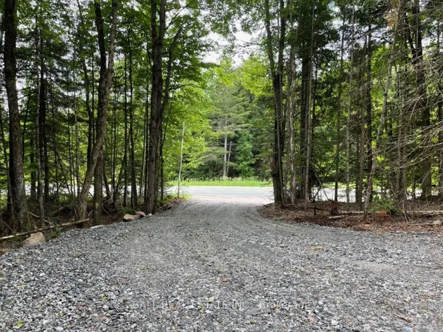
+"PublicRemarks": "You Can Have It All! Our site is a perfect opportunity to invest in or build on! A dream location for…? What a vision you can have here! Located on the desirable Delamere Road in the French River, with year-round access and walking distance to all amenities. The offering is multi faceted… level and accessible and our Driveway is installed. We provide a developable site with mixed topography, rock ridges & trees! You will be so “in” love with this stunning acreage that you will not want to leave! A beautiful piece of land!! Delamere Road brings you to thousands of acres of crown land! Some of the largest parcels in the area! Calling all hunters, nature lovers and explorers… This is a prime location for developing your wilderness escape, while enjoying the conveniences of town nearby. Hiking, snowmobileing and snowshoeing trails are minutes away! The famous French River is only a 5-minute drive for boating, fishing, public beaches, canoeing… think of the hours of enjoyment! This is an exceptional property with so many opportunities! Beyond the peaceful days & starlit nights this site beckons anyone with an appreciation of the great outdoors, a beautiful setting for adventures! This site maybe the perfect answer to fulfilling your Northern Dreams!! An opportunity to fully enjoy life!"
+"ArchitecturalStyle": "Unknown"
+"Basement": array:1 [
0 => "Unknown"
]
+"BuildingAreaUnits": "Square Feet"
+"ConstructionMaterials": array:1 [
0 => "Unknown"
]
+"Cooling": "Unknown"
+"Country": "CA"
+"CountyOrParish": "Sudbury"
+"CreationDate": "2025-11-04T18:06:05.139649+00:00"
+"CrossStreet": "Hwy 64 turn left onto Delamere RD. the property is on your right hand side. After # 76"
+"DirectionFaces": "Unknown"
+"Exclusions": "n/a"
+"ExpirationDate": "2026-05-25"
+"Inclusions": "n/a"
+"InteriorFeatures": "Unknown"
+"RFTransactionType": "For Sale"
+"InternetEntireListingDisplayYN": true
+"ListAOR": "One Point Association of REALTORS"
+"ListingContractDate": "2024-10-25"
+"LotSizeDimensions": "200 x 122"
+"MainOfficeKey": "547600"
+"MajorChangeTimestamp": "2025-10-18T15:51:49Z"
+"MlsStatus": "Extension"
+"OccupantType": "Vacant"
+"OriginalEntryTimestamp": "2024-10-25T13:33:01Z"
+"OriginalListPrice": 79900.0
+"OriginatingSystemID": "lar"
+"OriginatingSystemKey": "40669260"
+"ParcelNumber": "734450387"
+"ParkingFeatures": "Unknown"
+"PhotosChangeTimestamp": "2025-07-24T18:58:47Z"
+"PoolFeatures": "None"
+"Roof": "Unknown"
+"Sewer": "None"
+"ShowingRequirements": array:1 [
0 => "List Brokerage"
]
+"SourceSystemID": "lar"
+"SourceSystemName": "itso"
+"StateOrProvince": "ON"
+"StreetName": "DELAMERE"
+"StreetNumber": "LOT 25"
+"StreetSuffix": "Road"
+"TaxAnnualAmount": "518.76"
+"TaxAssessedValue": 24500
+"TaxBookNumber": "520101000043500"
+"TaxLegalDescription": "Delamere CON 1 LOT 6 PLAN M1092 LOT 25 PCL 45343."
+"TaxYear": "2025"
+"TransactionBrokerCompensation": "2.5+HST."
+"TransactionType": "For Sale"
+"Zoning": "R1"
+"DDFYN": true
+"Water": "None"
+"GasYNA": "No"
+"CableYNA": "No"
+"Exposure": "West"
+"HeatType": "Unknown"
+"LotDepth": 200.0
+"LotWidth": 122.0
+"SewerYNA": "No"
+"WaterYNA": "No"
+"@odata.id": "https://api.realtyfeed.com/reso/odata/Property('X10438142')"
+"GarageType": "Unknown"
+"HeatSource": "Unknown"
+"Waterfront": array:1 [
0 => "None"
]
+"ElectricYNA": "Available"
+"HoldoverDays": 365
+"TelephoneYNA": "Available"
+"ListPriceUnit": "For Sale"
+"provider_name": "TRREB"
+"AssessmentYear": 2024
+"ContractStatus": "Available"
+"HSTApplication": array:1 [
0 => "Call LBO"
]
+"PriorMlsStatus": "New"
+"MediaListingKey": "155109429"
+"AccessToProperty": array:1 [
0 => "Year Round Municipal Road"
]
+"LotSizeRangeAcres": ".50-1.99"
+"PossessionDetails": "Immediate"
+"SpecialDesignation": array:1 [
0 => "Unknown"
]
+"MediaChangeTimestamp": "2025-07-24T18:58:47Z"
+"ExtensionEntryTimestamp": "2025-10-18T15:51:49Z"
+"SystemModificationTimestamp": "2025-11-10T15:07:00.552091Z"
+"Media": array:6 [
0 => array:26 [ …26]
1 => array:26 [ …26]
2 => array:26 [ …26]
3 => array:26 [ …26]
4 => array:26 [ …26]
5 => array:26 [ …26]
]
+"ID": "152924"
}
2 => Realtyna\MlsOnTheFly\Components\CloudPost\SubComponents\RFClient\SDK\RF\Entities\RFProperty {#14598
+post_id: "622000"
+post_author: 1
+"ListingKey": "X12508470"
+"ListingId": "X12508470"
+"PropertyType": "Residential"
+"PropertySubType": "Vacant Land"
+"StandardStatus": "Active"
+"ModificationTimestamp": "2025-11-04T18:09:35Z"
+"RFModificationTimestamp": "2025-11-13T16:40:49Z"
+"ListPrice": 159900.0
+"BathroomsTotalInteger": 0
+"BathroomsHalf": 0
+"BedroomsTotal": 0
+"LotSizeArea": 0
+"LivingArea": 0
+"BuildingAreaTotal": 0
+"City": "Brighton"
+"PostalCode": "K0K 1H0"
+"UnparsedAddress": "Lot 31 Concession 2 Road, Brighton, ON K0K 1H0"
+"Coordinates": array:2 [
0 => -77.8347857
1 => 44.1779564
]
+"Latitude": 44.1779564
+"Longitude": -77.8347857
+"YearBuilt": 0
+"InternetAddressDisplayYN": true
+"FeedTypes": "IDX"
+"ListOfficeName": "ROYAL LEPAGE FRANK REAL ESTATE"
+"OriginatingSystemName": "TRREB"
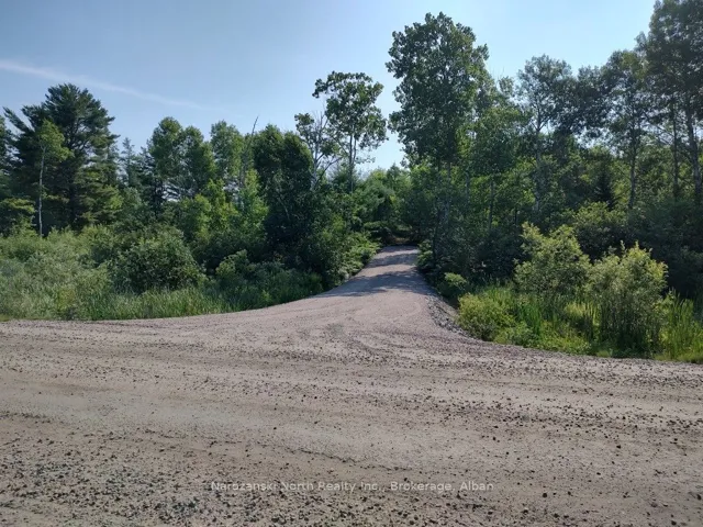
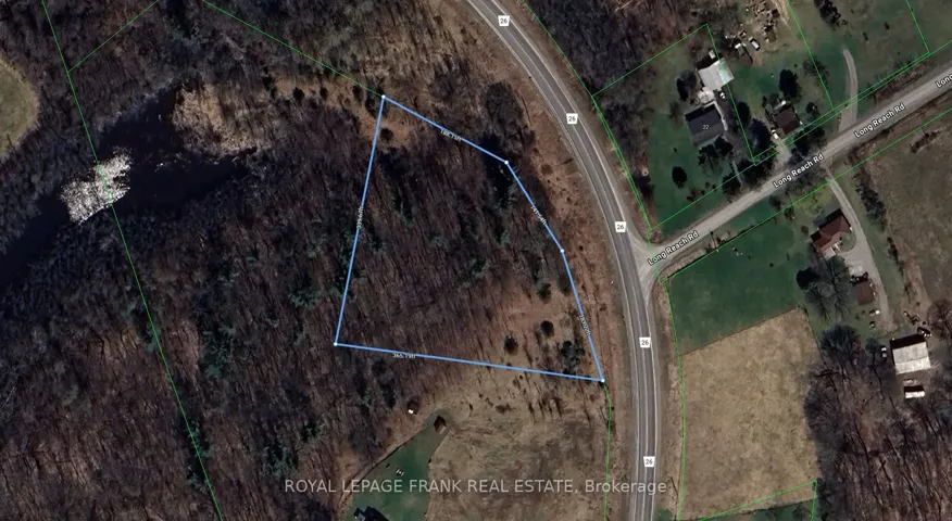
+"PublicRemarks": "This beautiful irregularly shaped parcel of land on County Rd 26 in Brighton offers the perfect opportunity to own your very own piece of the countryside. Enjoy the peace, privacy, and space of rural living while remaining just a short drive to all the conveniences of Brighton, Presqu'ile Park, and the 401. Current owners have acquired a Hydrologic Evaluation Report and an Entrance Permit from Northumberland County this property may provides a rare chance to plant roots in one of Northumberland's most picturesque country settings."
+"CityRegion": "Rural Brighton"
+"CountyOrParish": "Northumberland"
+"CreationDate": "2025-11-04T18:35:59.686366+00:00"
+"CrossStreet": "Long Reach Rd & County Rd 26"
+"DirectionFaces": "West"
+"Directions": "Long Reach Rd & County Rd 26"
+"ExpirationDate": "2026-01-31"
+"RFTransactionType": "For Sale"
+"InternetEntireListingDisplayYN": true
+"ListAOR": "Central Lakes Association of REALTORS"
+"ListingContractDate": "2025-11-04"
+"MainOfficeKey": "522700"
+"MajorChangeTimestamp": "2025-11-04T17:55:44Z"
+"MlsStatus": "New"
+"OccupantType": "Vacant"
+"OriginalEntryTimestamp": "2025-11-04T17:55:44Z"
+"OriginalListPrice": 159900.0
+"OriginatingSystemID": "A00001796"
+"OriginatingSystemKey": "Draft3218918"
+"ParcelNumber": "511830321"
+"PhotosChangeTimestamp": "2025-11-04T17:55:44Z"
+"ShowingRequirements": array:1 [
0 => "Go Direct"
]
+"SourceSystemID": "A00001796"
+"SourceSystemName": "Toronto Regional Real Estate Board"
+"StateOrProvince": "ON"
+"StreetName": "Concession 2"
+"StreetNumber": "Lot 31"
+"StreetSuffix": "Road"
+"TaxAnnualAmount": "882.14"
+"TaxLegalDescription": "PART LOT 31, CONCESSION 2 BRIGHTON, PART 2, PLAN 39R14884 MUNICIPALITY OF BRIGHTON"
+"TaxYear": "2025"
+"TransactionBrokerCompensation": "2% + HST"
+"TransactionType": "For Sale"
+"DDFYN": true
+"GasYNA": "No"
+"CableYNA": "No"
+"LotDepth": 365.19
+"LotWidth": 339.67
+"SewerYNA": "No"
+"WaterYNA": "No"
+"@odata.id": "https://api.realtyfeed.com/reso/odata/Property('X12508470')"
+"SurveyType": "None"
+"Waterfront": array:1 [
0 => "None"
]
+"ElectricYNA": "No"
+"HoldoverDays": 90
+"TelephoneYNA": "No"
+"provider_name": "TRREB"
+"short_address": "Brighton, ON K0K 1H0, CA"
+"ContractStatus": "Available"
+"HSTApplication": array:1 [
0 => "Included In"
]
+"PossessionType": "Immediate"
+"PriorMlsStatus": "Draft"
+"LotIrregularities": "339.67 ft x 365.19 ft x 183.22 ft x 141."
+"LotSizeRangeAcres": ".50-1.99"
+"PossessionDetails": "Immediate"
+"SpecialDesignation": array:1 [
0 => "Unknown"
]
+"MediaChangeTimestamp": "2025-11-04T17:55:44Z"
+"SystemModificationTimestamp": "2025-11-04T18:09:35.554262Z"
+"Media": array:2 [
0 => array:26 [ …26]
1 => array:26 [ …26]
]
+"ID": "622000"
}
3 => Realtyna\MlsOnTheFly\Components\CloudPost\SubComponents\RFClient\SDK\RF\Entities\RFProperty {#14593
+post_id: "535619"
+post_author: 1
+"ListingKey": "X12362318"
+"ListingId": "X12362318"
+"PropertyType": "Residential"
+"PropertySubType": "Vacant Land"
+"StandardStatus": "Active"
+"ModificationTimestamp": "2025-11-01T16:12:08Z"
+"RFModificationTimestamp": "2025-11-14T05:21:41Z"
+"ListPrice": 319900.0
+"BathroomsTotalInteger": 0
+"BathroomsHalf": 0
+"BedroomsTotal": 0
+"LotSizeArea": 0.21
+"LivingArea": 0
+"BuildingAreaTotal": 0
+"City": "Kawartha Lakes"
+"PostalCode": "K0M 2B0"
+"UnparsedAddress": "78 Antiquary Road, Kawartha Lakes, ON K0M 2B0"
+"Coordinates": array:2 [
0 => -79.0502145
1 => 44.5503135
]
+"Latitude": 44.5503135
+"Longitude": -79.0502145
+"YearBuilt": 0
+"InternetAddressDisplayYN": true
+"FeedTypes": "IDX"
+"ListOfficeName": "RE/MAX ALL-STARS REALTY INC."
+"OriginatingSystemName": "TRREB"
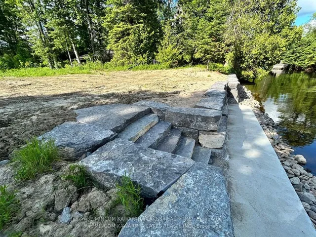
+"PublicRemarks": "Vacant waterfront lot on perhaps the nicest shoreline of Canal Lake with hard bottom sand shoreline and breathtaking sunset views. Canal Lake is located between Lake Simcoe and Balsam Lake with the main channel of the Trent-Severn Waterway just off the shoreline. Property is conveniently located close to Centennial Park Road and Hwy 48. Great summer and winter fishing. Antiquary Beach Association dues are $125 per year due in July. 2025 fees have been paid. Access is by an un-assumed municipal road."
+"CityRegion": "Eldon"
+"Country": "CA"
+"CountyOrParish": "Kawartha Lakes"
+"CreationDate": "2025-11-04T18:45:12.397876+00:00"
+"CrossStreet": "Hwy 48/Centennial Park Rd"
+"DirectionFaces": "West"
+"Directions": "Hwy 48 to Centennial Park Rd, to Antiquary Rd."
+"Disclosures": array:1 [
0 => "Unknown"
]
+"ExpirationDate": "2025-12-31"
+"RFTransactionType": "For Sale"
+"InternetEntireListingDisplayYN": true
+"ListAOR": "Central Lakes Association of REALTORS"
+"ListingContractDate": "2025-08-25"
+"LotSizeDimensions": "181 x 50"
+"LotSizeSource": "Geo Warehouse"
+"MainOfficeKey": "142000"
+"MajorChangeTimestamp": "2025-11-01T16:12:08Z"
+"MlsStatus": "Price Change"
+"OccupantType": "Vacant"
+"OriginalEntryTimestamp": "2025-08-25T14:39:17Z"
+"OriginalListPrice": 339900.0
+"OriginatingSystemID": "A00001796"
+"OriginatingSystemKey": "Draft2891552"
+"ParcelNumber": "631700505"
+"ParkingFeatures": "Private"
+"PhotosChangeTimestamp": "2025-08-25T14:39:18Z"
+"PreviousListPrice": 339900.0
+"PriceChangeTimestamp": "2025-11-01T16:12:08Z"
+"Sewer": "None"
+"ShowingRequirements": array:1 [
0 => "Showing System"
]
+"SourceSystemID": "A00001796"
+"SourceSystemName": "Toronto Regional Real Estate Board"
+"StateOrProvince": "ON"
+"StreetName": "Antiquary"
+"StreetNumber": "78"
+"StreetSuffix": "Road"
+"TaxAnnualAmount": "1175.77"
+"TaxAssessedValue": 100000
+"TaxBookNumber": "165116005059600"
+"TaxLegalDescription": "LOT 30 PLAN 215; PTC 1061B LOT 30A; PT LT 17 CON N PORTAGE RD ELDON; AS IN A52124; KAWARTHA LAKES"
+"TaxYear": "2025"
+"Topography": array:1 [
0 => "Flat"
]
+"TransactionBrokerCompensation": "2.5%"
+"TransactionType": "For Sale"
+"View": array:2 [
0 => "Lake"
1 => "Water"
]
+"WaterBodyName": "Canal Lake"
+"WaterSource": array:1 [
0 => "Dug Well"
]
+"WaterfrontFeatures": "Trent System,Dock"
+"WaterfrontYN": true
+"Zoning": "Limited Service Residential (RR3)"
+"DDFYN": true
+"Water": "Well"
+"GasYNA": "No"
+"CableYNA": "No"
+"LotDepth": 181.0
+"LotShape": "Rectangular"
+"LotWidth": 50.0
+"SewerYNA": "No"
+"WaterYNA": "No"
+"@odata.id": "https://api.realtyfeed.com/reso/odata/Property('X12362318')"
+"Shoreline": array:2 [
0 => "Hard Bottom"
1 => "Sandy"
]
+"WaterView": array:2 [
0 => "Direct"
1 => "Unobstructive"
]
+"RollNumber": "165116005059600"
+"SurveyType": "None"
+"Waterfront": array:1 [
0 => "Direct"
]
+"DockingType": array:1 [
0 => "Private"
]
+"ElectricYNA": "No"
+"HoldoverDays": 90
+"TelephoneYNA": "No"
+"WaterBodyType": "Lake"
+"provider_name": "TRREB"
+"short_address": "Kawartha Lakes, ON K0M 2B0, CA"
+"AssessmentYear": 2025
+"ContractStatus": "Available"
+"HSTApplication": array:1 [
0 => "Not Subject to HST"
]
+"PossessionDate": "2025-10-15"
+"PossessionType": "Flexible"
+"PriorMlsStatus": "New"
+"WaterFrontageFt": "50.0000"
+"AccessToProperty": array:1 [
0 => "Other"
]
+"AlternativePower": array:1 [
0 => "None"
]
+"LotSizeAreaUnits": "Acres"
+"LotSizeRangeAcres": "< .50"
+"PossessionDetails": "Flexible"
+"ShorelineExposure": "West"
+"ShorelineAllowance": "Owned"
+"SpecialDesignation": array:1 [
0 => "Unknown"
]
+"WaterfrontAccessory": array:1 [
0 => "Not Applicable"
]
+"MediaChangeTimestamp": "2025-08-25T14:39:18Z"
+"SystemModificationTimestamp": "2025-11-01T16:12:08.844358Z"
+"Media": array:14 [
0 => array:26 [ …26]
1 => array:26 [ …26]
2 => array:26 [ …26]
3 => array:26 [ …26]
4 => array:26 [ …26]
5 => array:26 [ …26]
6 => array:26 [ …26]
7 => array:26 [ …26]
8 => array:26 [ …26]
9 => array:26 [ …26]
10 => array:26 [ …26]
11 => array:26 [ …26]
12 => array:26 [ …26]
13 => array:26 [ …26]
]
+"ID": "535619"
}
4 => Realtyna\MlsOnTheFly\Components\CloudPost\SubComponents\RFClient\SDK\RF\Entities\RFProperty {#14592
+post_id: "621331"
+post_author: 1
+"ListingKey": "X12508922"
+"ListingId": "X12508922"
+"PropertyType": "Residential"
+"PropertySubType": "Vacant Land"
+"StandardStatus": "Active"
+"ModificationTimestamp": "2025-11-07T15:44:50Z"
+"RFModificationTimestamp": "2025-11-14T07:05:08Z"
+"ListPrice": 289000.0
+"BathroomsTotalInteger": 0
+"BathroomsHalf": 0
+"BedroomsTotal": 0
+"LotSizeArea": 0
+"LivingArea": 0
+"BuildingAreaTotal": 0
+"City": "Dysart Et Al"
+"PostalCode": "K0M 1S0"
+"UnparsedAddress": "1350 Haliburton Lake Rd N/a, Dysart Et Al, ON K0M 1S0"
+"Coordinates": array:2 [
0 => -78.4003082
1 => 45.2007432
]
+"Latitude": 45.2007432
+"Longitude": -78.4003082
+"YearBuilt": 0
+"InternetAddressDisplayYN": true
+"FeedTypes": "IDX"
+"ListOfficeName": "BALL REAL ESTATE INC."
+"OriginatingSystemName": "TRREB"
+"PublicRemarks": "If you are looking to build your own home on a lovely private acreage just minutes outside of Haliburton village, then this might be the parcel for you. The driveway and a large turn around area have been completed for you on the northern edge of the property. From there, choose your building site amongst the towering maples and gently rolling terrain. There is also a buildable area towards the south end of the property. The southern portion of the acreage is a large wetland and would appeal to the nature lover or environmentalist. Set back off the year round municipal road and school bus route, enjoy the wildlife and privacy on this parcel. Hydro and Bell run along the front lot line and high speed internet is available. If you enjoy snowmobiling, the trails are nearby. Five minutes away is the Eagle Lake Country market which offers gas, LCBO and post office. As well, the public beach and boat launch are just down the road. Five minutes further is Sir Sam's Ski and Bike where the whole family can enjoy the outdoors. This a great location, close to golf, ATV trails, amenities, and hospital. Don't miss this opportunity to create your own private retreat."
+"CityRegion": "Dysart"
+"Country": "CA"
+"CountyOrParish": "Haliburton"
+"CreationDate": "2025-11-04T19:32:46.057511+00:00"
+"CrossStreet": "Highway 118"
+"DirectionFaces": "East"
+"Directions": "PT LT 14 CON 13 DYSART AS IN H55853 S OF HWY 519; DYSART ET AL"
+"ExpirationDate": "2026-05-01"
+"InteriorFeatures": "None"
+"RFTransactionType": "For Sale"
+"InternetEntireListingDisplayYN": true
+"ListAOR": "Central Lakes Association of REALTORS"
+"ListingContractDate": "2025-11-04"
+"LotSizeSource": "Geo Warehouse"
+"MainOfficeKey": "333400"
+"MajorChangeTimestamp": "2025-11-04T18:58:50Z"
+"MlsStatus": "New"
+"OccupantType": "Vacant"
+"OriginalEntryTimestamp": "2025-11-04T18:58:50Z"
+"OriginalListPrice": 289000.0
+"OriginatingSystemID": "A00001796"
+"OriginatingSystemKey": "Draft3220060"
+"ParcelNumber": "391850052"
+"ParkingFeatures": "Private"
+"ParkingTotal": "3.0"
+"PhotosChangeTimestamp": "2025-11-04T18:58:50Z"
+"Sewer": "None"
+"ShowingRequirements": array:1 [
0 => "Showing System"
]
+"SourceSystemID": "A00001796"
+"SourceSystemName": "Toronto Regional Real Estate Board"
+"StateOrProvince": "ON"
+"StreetName": "Haliburton Lake Rd"
+"StreetNumber": "1350"
+"StreetSuffix": "N/A"
+"TaxAnnualAmount": "2323.13"
+"TaxAssessedValue": 53000
+"TaxLegalDescription": "PT LT 14 CON 13 DYSART AS IN H55853 S OF HWY 519; DYSART ET AL"
+"TaxYear": "2025"
+"TransactionBrokerCompensation": "2.5%"
+"TransactionType": "For Sale"
+"Zoning": "RU1 & EP"
+"DDFYN": true
+"Water": "None"
+"GasYNA": "No"
+"CableYNA": "No"
+"LotDepth": 1011.0
+"LotWidth": 2007.96
+"SewerYNA": "No"
+"WaterYNA": "No"
+"@odata.id": "https://api.realtyfeed.com/reso/odata/Property('X12508922')"
+"RollNumber": "462401130001490"
+"SurveyType": "Unknown"
+"Waterfront": array:1 [
0 => "None"
]
+"ElectricYNA": "Available"
+"HoldoverDays": 30
+"TelephoneYNA": "Available"
+"ParkingSpaces": 3
+"provider_name": "TRREB"
+"AssessmentYear": 2025
+"ContractStatus": "Available"
+"HSTApplication": array:1 [
0 => "Not Subject to HST"
]
+"PossessionType": "Immediate"
+"PriorMlsStatus": "Draft"
+"PropertyFeatures": array:3 [
0 => "Beach"
1 => "Golf"
2 => "Hospital"
]
+"LotIrregularities": "Irregular one side of lot line is 2543ft"
+"LotSizeRangeAcres": "50-99.99"
+"PossessionDetails": "immediate"
+"SpecialDesignation": array:1 [
0 => "Unknown"
]
+"MediaChangeTimestamp": "2025-11-07T15:44:50Z"
+"SystemModificationTimestamp": "2025-11-07T15:44:50.899176Z"
+"Media": array:14 [
0 => array:26 [ …26]
1 => array:26 [ …26]
2 => array:26 [ …26]
3 => array:26 [ …26]
4 => array:26 [ …26]
5 => array:26 [ …26]
6 => array:26 [ …26]
7 => array:26 [ …26]
8 => array:26 [ …26]
9 => array:26 [ …26]
10 => array:26 [ …26]
11 => array:26 [ …26]
12 => array:26 [ …26]
13 => array:26 [ …26]
]
+"ID": "621331"
}
5 => Realtyna\MlsOnTheFly\Components\CloudPost\SubComponents\RFClient\SDK\RF\Entities\RFProperty {#14600
+post_id: "620964"
+post_author: 1
+"ListingKey": "X12509364"
+"ListingId": "X12509364"
+"PropertyType": "Residential"
+"PropertySubType": "Vacant Land"
+"StandardStatus": "Active"
+"ModificationTimestamp": "2025-11-04T19:53:01Z"
+"RFModificationTimestamp": "2025-11-12T01:28:17Z"
+"ListPrice": 169900.0
+"BathroomsTotalInteger": 0
+"BathroomsHalf": 0
+"BedroomsTotal": 0
+"LotSizeArea": 2.58
+"LivingArea": 0
+"BuildingAreaTotal": 0
+"City": "Seguin"
+"PostalCode": "P2A 2W8"
+"UnparsedAddress": "Part 19 Standing People Road, Seguin, ON P2A 2W8"
+"Coordinates": array:2 [
0 => -79.789365
1 => 45.319669
]
+"Latitude": 45.319669
+"Longitude": -79.789365
+"YearBuilt": 0
+"InternetAddressDisplayYN": true
+"FeedTypes": "IDX"
+"ListOfficeName": "RE/MAX Parry Sound Muskoka Realty Ltd"
+"OriginatingSystemName": "TRREB"
+"PublicRemarks": "This 2.58-acre lot sits on a quiet township road in Seguin, about 15 minutes from Parry Sound and minutes to Humphrey School. There's 209 feet of frontage with a treed backdrop that keeps things quiet and private. Plenty of room to plan a country home or simple retreat.Hydro is at the road. HST applies and is not included in the list price."
+"CityRegion": "Seguin"
+"CoListOfficeName": "RE/MAX Parry Sound Muskoka Realty Ltd"
+"CoListOfficePhone": "705-746-9336"
+"Country": "CA"
+"CountyOrParish": "Parry Sound"
+"CreationDate": "2025-11-04T20:11:24.574528+00:00"
+"CrossStreet": "Elsasser Road and Standing People Road"
+"DirectionFaces": "West"
+"Directions": "Highway 141 to Allan Crescent then north on Elsasser Road. Follow approx 1 k, then bear right onto Standing People Road to SOP on left."
+"ExpirationDate": "2026-04-30"
+"RFTransactionType": "For Sale"
+"InternetEntireListingDisplayYN": true
+"ListAOR": "One Point Association of REALTORS"
+"ListingContractDate": "2025-11-03"
+"LotSizeSource": "Survey"
+"MainOfficeKey": "547700"
+"MajorChangeTimestamp": "2025-11-04T19:53:01Z"
+"MlsStatus": "New"
+"OccupantType": "Vacant"
+"OriginalEntryTimestamp": "2025-11-04T19:53:01Z"
+"OriginalListPrice": 169900.0
+"OriginatingSystemID": "A00001796"
+"OriginatingSystemKey": "Draft3220734"
+"ParcelNumber": "521770485"
+"PhotosChangeTimestamp": "2025-11-04T19:53:01Z"
+"ShowingRequirements": array:1 [
0 => "Go Direct"
]
+"SignOnPropertyYN": true
+"SourceSystemID": "A00001796"
+"SourceSystemName": "Toronto Regional Real Estate Board"
+"StateOrProvince": "ON"
+"StreetName": "Standing People"
+"StreetNumber": "Part 19"
+"StreetSuffix": "Road"
+"TaxAnnualAmount": "160.95"
+"TaxAssessedValue": 27500
+"TaxLegalDescription": "PT LT 34 CON 1 CHRISTIE PT 19 PSR2153; T/W RO212301; SEGUIN SUBJECT TO AN EASEMENT IN GROSS OVER PART 7, PLAN 42R22693 AS IN GB182691"
+"TaxYear": "2025"
+"TransactionBrokerCompensation": "2.5"
+"TransactionType": "For Sale"
+"Zoning": "RR"
+"DDFYN": true
+"GasYNA": "No"
+"CableYNA": "No"
+"LotDepth": 692.0
+"LotWidth": 209.0
+"SewerYNA": "No"
+"WaterYNA": "No"
+"@odata.id": "https://api.realtyfeed.com/reso/odata/Property('X12509364')"
+"RollNumber": "490304000401718"
+"SurveyType": "Boundary Only"
+"Waterfront": array:1 [
0 => "None"
]
+"ElectricYNA": "Available"
+"HoldoverDays": 30
+"TelephoneYNA": "No"
+"provider_name": "TRREB"
+"short_address": "Seguin, ON P2A 2W8, CA"
+"AssessmentYear": 2025
+"ContractStatus": "Available"
+"HSTApplication": array:1 [
0 => "In Addition To"
]
+"PossessionType": "Immediate"
+"PriorMlsStatus": "Draft"
+"AccessToProperty": array:1 [
0 => "Year Round Municipal Road"
]
+"LotSizeAreaUnits": "Acres"
+"CoListOfficeName3": "RE/MAX Parry Sound Muskoka Realty Ltd"
+"LotSizeRangeAcres": "2-4.99"
+"PossessionDetails": "On Closing"
+"SpecialDesignation": array:1 [
0 => "Unknown"
]
+"MediaChangeTimestamp": "2025-11-04T19:53:01Z"
+"SystemModificationTimestamp": "2025-11-04T19:53:01.172932Z"
+"Media": array:3 [
0 => array:26 [ …26]
1 => array:26 [ …26]
2 => array:26 [ …26]
]
+"ID": "620964"
}
6 => Realtyna\MlsOnTheFly\Components\CloudPost\SubComponents\RFClient\SDK\RF\Entities\RFProperty {#14433
+post_id: "620968"
+post_author: 1
+"ListingKey": "X12509342"
+"ListingId": "X12509342"
+"PropertyType": "Residential"
+"PropertySubType": "Vacant Land"
+"StandardStatus": "Active"
+"ModificationTimestamp": "2025-11-07T16:56:12Z"
+"RFModificationTimestamp": "2025-11-11T17:49:33Z"
+"ListPrice": 169900.0
+"BathroomsTotalInteger": 0
+"BathroomsHalf": 0
+"BedroomsTotal": 0
+"LotSizeArea": 2.57
+"LivingArea": 0
+"BuildingAreaTotal": 0
+"City": "Seguin"
+"PostalCode": "P2A 2W8"
+"UnparsedAddress": "Part 7 Standing People Road, Seguin, ON P2A 2W8"
+"Coordinates": array:2 [
0 => -79.789365
1 => 45.319669
]
+"Latitude": 45.319669
+"Longitude": -79.789365
+"YearBuilt": 0
+"InternetAddressDisplayYN": true
+"FeedTypes": "IDX"
+"ListOfficeName": "RE/MAX Parry Sound Muskoka Realty Ltd"
+"OriginatingSystemName": "TRREB"
+"PublicRemarks": "2.9-acre building lot on a quiet, newly constructed township road in Seguin, approximately 15 minutes from Parry Sound and just 5 minutes from Humphrey School. With 209 feet of frontage with a nice stand of hardwoods, you've got some privacy right off the road. Hydro is now on the road. A great property for those looking to build in a quiet, wooded setting. HST is in addition to the purchase price"
+"CityRegion": "Seguin"
+"CoListOfficeName": "RE/MAX Parry Sound Muskoka Realty Ltd"
+"CoListOfficePhone": "705-746-9336"
+"Country": "CA"
+"CountyOrParish": "Parry Sound"
+"CreationDate": "2025-11-04T20:12:47.914802+00:00"
+"CrossStreet": "Elsasser Road and Standing People Road"
+"DirectionFaces": "East"
+"Directions": "Highway 141 to Allan Crescent then north on Elsasser Road. Follow approx 1 k, then bear right onto Standing People Road to SOP on left."
+"ExpirationDate": "2026-04-30"
+"RFTransactionType": "For Sale"
+"InternetEntireListingDisplayYN": true
+"ListAOR": "One Point Association of REALTORS"
+"ListingContractDate": "2025-11-03"
+"MainOfficeKey": "547700"
+"MajorChangeTimestamp": "2025-11-04T19:51:25Z"
+"MlsStatus": "New"
+"OccupantType": "Vacant"
+"OriginalEntryTimestamp": "2025-11-04T19:51:25Z"
+"OriginalListPrice": 169900.0
+"OriginatingSystemID": "A00001796"
+"OriginatingSystemKey": "Draft3220316"
+"ParcelNumber": "521770485"
+"PhotosChangeTimestamp": "2025-11-07T16:56:13Z"
+"ShowingRequirements": array:1 [
0 => "Go Direct"
]
+"SignOnPropertyYN": true
+"SourceSystemID": "A00001796"
+"SourceSystemName": "Toronto Regional Real Estate Board"
+"StateOrProvince": "ON"
+"StreetName": "Standing People"
+"StreetNumber": "Part 7"
+"StreetSuffix": "Road"
+"TaxAnnualAmount": "149.25"
+"TaxAssessedValue": 25500
+"TaxLegalDescription": "PT LT 34 CON 1 CHRISTIE PT 7 PSR2153; T/W RO212417 TOWNSHIP OF SEGUIN"
+"TaxYear": "2025"
+"TransactionBrokerCompensation": "2.5"
+"TransactionType": "For Sale"
+"Zoning": "RR"
+"DDFYN": true
+"GasYNA": "No"
+"CableYNA": "No"
+"LotDepth": 582.0
+"LotShape": "Rectangular"
+"LotWidth": 214.0
+"SewerYNA": "No"
+"WaterYNA": "No"
+"@odata.id": "https://api.realtyfeed.com/reso/odata/Property('X12509342')"
+"RollNumber": "490304000401706"
+"SurveyType": "Boundary Only"
+"Waterfront": array:1 [
0 => "None"
]
+"ElectricYNA": "Available"
+"HoldoverDays": 30
+"TelephoneYNA": "No"
+"provider_name": "TRREB"
+"AssessmentYear": 2025
+"ContractStatus": "Available"
+"HSTApplication": array:1 [
0 => "In Addition To"
]
+"PossessionType": "Immediate"
+"PriorMlsStatus": "Draft"
+"AccessToProperty": array:1 [
0 => "Year Round Municipal Road"
]
+"LotSizeAreaUnits": "Acres"
+"ParcelOfTiedLand": "No"
+"CoListOfficeName3": "RE/MAX Parry Sound Muskoka Realty Ltd"
+"LotSizeRangeAcres": "2-4.99"
+"PossessionDetails": "On closing"
+"SpecialDesignation": array:1 [
0 => "Unknown"
]
+"MediaChangeTimestamp": "2025-11-07T16:56:13Z"
+"SystemModificationTimestamp": "2025-11-07T16:56:12.993112Z"
+"Media": array:22 [
0 => array:26 [ …26]
1 => array:26 [ …26]
2 => array:26 [ …26]
3 => array:26 [ …26]
4 => array:26 [ …26]
5 => array:26 [ …26]
6 => array:26 [ …26]
7 => array:26 [ …26]
8 => array:26 [ …26]
9 => array:26 [ …26]
10 => array:26 [ …26]
11 => array:26 [ …26]
12 => array:26 [ …26]
13 => array:26 [ …26]
14 => array:26 [ …26]
15 => array:26 [ …26]
16 => array:26 [ …26]
17 => array:26 [ …26]
18 => array:26 [ …26]
19 => array:26 [ …26]
20 => array:26 [ …26]
21 => array:26 [ …26]
]
+"ID": "620968"
}
7 => Realtyna\MlsOnTheFly\Components\CloudPost\SubComponents\RFClient\SDK\RF\Entities\RFProperty {#14594
+post_id: "620835"
+post_author: 1
+"ListingKey": "X12509474"
+"ListingId": "X12509474"
+"PropertyType": "Residential"
+"PropertySubType": "Vacant Land"
+"StandardStatus": "Active"
+"ModificationTimestamp": "2025-11-07T15:36:12Z"
+"RFModificationTimestamp": "2025-11-14T07:05:08Z"
+"ListPrice": 999000.0
+"BathroomsTotalInteger": 0
+"BathroomsHalf": 0
+"BedroomsTotal": 0
+"LotSizeArea": 9085.04
+"LivingArea": 0
+"BuildingAreaTotal": 0
+"City": "Britannia - Lincoln Heights And Area"
+"PostalCode": "K2B 6E1"
+"UnparsedAddress": "38 Farrow Street, Britannia - Lincoln Heights And Area, ON K2B 6E1"
+"Coordinates": array:2 [
0 => -75.801225
1 => 45.362883
]
+"Latitude": 45.362883
+"Longitude": -75.801225
+"YearBuilt": 0
+"InternetAddressDisplayYN": true
+"FeedTypes": "IDX"
+"ListOfficeName": "EXIT EXCEL REALTY"
+"OriginatingSystemName": "TRREB"
+"PublicRemarks": "Rare development opportunity in Ottawa's west end! 38 Farrow Street sits on a generous lot offering strong potential under both current R3A zoning and the new 2026 Final Draft By-Law N3C, scheduled for adoption January 2026. The updated framework expands density permissions, simplifies setbacks and allows broader housing forms. Options include potential to sever the parcel into two developable lots, each capable of supporting multi-unit buildings of up to 8, possibly 9 units, or alternatively up to 5 attached homes with stunning views from potential rooftop terraces across the property. Located within an established residential community near transit, parks & amenities, this site is ideal for infill developers or investors seeking to capitalize on Ottawa's next wave of growth. See attached property flyer for full zoning details and development scenarios."
+"CityRegion": "6101 - Britannia"
+"Country": "CA"
+"CountyOrParish": "Ottawa"
+"CreationDate": "2025-11-04T20:20:38.527984+00:00"
+"CrossStreet": "Carling & Scrivens"
+"DirectionFaces": "South"
+"Directions": "From Carling, north on Scrivens, right on Ahearn which turns into Farrow at the bend to the left by soccer field. Follow to the top. Lot is located at the corner of Farrow & Grandeur."
+"ExpirationDate": "2026-01-03"
+"InteriorFeatures": "None"
+"RFTransactionType": "For Sale"
+"InternetEntireListingDisplayYN": true
+"ListAOR": "Ottawa Real Estate Board"
+"ListingContractDate": "2025-11-04"
+"LotSizeSource": "MPAC"
+"MainOfficeKey": "488400"
+"MajorChangeTimestamp": "2025-11-04T20:14:07Z"
+"MlsStatus": "New"
+"OccupantType": "Vacant"
+"OriginalEntryTimestamp": "2025-11-04T20:14:07Z"
+"OriginalListPrice": 999000.0
+"OriginatingSystemID": "A00001796"
+"OriginatingSystemKey": "Draft3220760"
+"ParcelNumber": "042820279"
+"PhotosChangeTimestamp": "2025-11-04T20:14:08Z"
+"Sewer": "None"
+"ShowingRequirements": array:1 [
0 => "Showing System"
]
+"SourceSystemID": "A00001796"
+"SourceSystemName": "Toronto Regional Real Estate Board"
+"StateOrProvince": "ON"
+"StreetName": "Farrow"
+"StreetNumber": "38"
+"StreetSuffix": "Street"
+"TaxAnnualAmount": "6900.0"
+"TaxLegalDescription": "PT BLK A, PL 209 , AS IN CR418711 ; OTTAWA/NEPEAN"
+"TaxYear": "2024"
+"Topography": array:2 [
0 => "Flat"
1 => "Partially Cleared"
]
+"TransactionBrokerCompensation": "2%"
+"TransactionType": "For Sale"
+"WaterBodyName": "Ottawa River"
+"Zoning": "R3A[561]"
+"DDFYN": true
+"Water": "None"
+"GasYNA": "Available"
+"CableYNA": "Available"
+"LotDepth": 99.88
+"LotShape": "Irregular"
+"LotWidth": 109.37
+"SewerYNA": "Available"
+"WaterYNA": "Available"
+"@odata.id": "https://api.realtyfeed.com/reso/odata/Property('X12509474')"
+"WaterView": array:1 [
0 => "Partially Obstructive"
]
+"RollNumber": "61409510244400"
+"SurveyType": "None"
+"Waterfront": array:1 [
0 => "Indirect"
]
+"ElectricYNA": "Available"
+"HoldoverDays": 60
+"TelephoneYNA": "Available"
+"WaterBodyType": "River"
+"provider_name": "TRREB"
+"ContractStatus": "Available"
+"HSTApplication": array:1 [
0 => "Included In"
]
+"PossessionType": "Flexible"
+"PriorMlsStatus": "Draft"
+"LotSizeAreaUnits": "Square Feet"
+"PropertyFeatures": array:6 [
0 => "Beach"
1 => "Marina"
2 => "Part Cleared"
3 => "Public Transit"
4 => "School"
5 => "River/Stream"
]
+"LotSizeRangeAcres": "< .50"
+"PossessionDetails": "Flexible"
+"ShorelineExposure": "North"
+"SpecialDesignation": array:1 [
0 => "Unknown"
]
+"MediaChangeTimestamp": "2025-11-04T20:14:08Z"
+"SystemModificationTimestamp": "2025-11-07T15:36:12.95314Z"
+"PermissionToContactListingBrokerToAdvertise": true
+"Media": array:7 [
0 => array:26 [ …26]
1 => array:26 [ …26]
2 => array:26 [ …26]
3 => array:26 [ …26]
4 => array:26 [ …26]
5 => array:26 [ …26]
6 => array:26 [ …26]
]
+"ID": "620835"
}
8 => Realtyna\MlsOnTheFly\Components\CloudPost\SubComponents\RFClient\SDK\RF\Entities\RFProperty {#14595
+post_id: "616181"
+post_author: 1
+"ListingKey": "X12494870"
+"ListingId": "X12494870"
+"PropertyType": "Residential"
+"PropertySubType": "Vacant Land"
+"StandardStatus": "Active"
+"ModificationTimestamp": "2025-10-31T13:20:04Z"
+"RFModificationTimestamp": "2025-11-14T15:35:58Z"
+"ListPrice": 199900.0
+"BathroomsTotalInteger": 0
+"BathroomsHalf": 0
+"BedroomsTotal": 0
+"LotSizeArea": 0
+"LivingArea": 0
+"BuildingAreaTotal": 0
+"City": "Huntsville"
+"PostalCode": "P1H 1B1"
+"UnparsedAddress": "19 Deerhurst Highlands Drive, Huntsville, ON P1H 1B1"
+"Coordinates": array:2 [
0 => -79.148422
1 => 45.348665
]
+"Latitude": 45.348665
+"Longitude": -79.148422
+"YearBuilt": 0
+"InternetAddressDisplayYN": true
+"FeedTypes": "IDX"
+"ListOfficeName": "FARIS TEAM REAL ESTATE BROKERAGE"
+"OriginatingSystemName": "TRREB"
+"PublicRemarks": "Top 5 Reasons You Will Love This Property: 1) Nestled atop Deerhurst Ridge, this exceptional lot offers breathtaking panoramic views overlooking the prestigious Deerhurst Highlands Golf Club, the elevated position captures the essence of Muskoka living, peaceful, scenic, and inspiring 2) Enjoy stunning sunset views as the property's west-facing exposure floods the landscape with warm, natural light, the outlook across manicured fairways and rolling hills creates an idyllic backdrop for your future home 3) Surrounded by mature trees and pristine Muskoka forest, this property delivers the perfect balance of seclusion and connection to nature, the lot's topography blends seamlessly into its surroundings, offering both beauty and tranquility 4) Whether you plan to build your dream home from the ground up or collaborate with Stratton Homes to create a custom-designed Muskoka retreat, this property provides the flexibility and inspiration to make your vision a reality 5) Just minutes from Deerhurst Resort, you'll have access to championship golf, fine dining, spa services, and four-season recreation, from lakeside summers to snow-covered winters, all within a serene, upscale setting that defines the Muskoka lifestyle."
+"CityRegion": "Chaffey"
+"CoListOfficeName": "FARIS TEAM REAL ESTATE BROKERAGE"
+"CoListOfficePhone": "705-797-8485"
+"Country": "CA"
+"CountyOrParish": "Muskoka"
+"CreationDate": "2025-11-04T20:22:47.671953+00:00"
+"CrossStreet": "Hwy 60/Deerhurst Highlands Dr"
+"DirectionFaces": "West"
+"Directions": "Hwy 60/Deerhurst Highlands Dr"
+"ExpirationDate": "2026-01-31"
+"RFTransactionType": "For Sale"
+"InternetEntireListingDisplayYN": true
+"ListAOR": "Toronto Regional Real Estate Board"
+"ListingContractDate": "2025-10-31"
+"MainOfficeKey": "239900"
+"MajorChangeTimestamp": "2025-10-31T13:11:38Z"
+"MlsStatus": "New"
+"OccupantType": "Vacant"
+"OriginalEntryTimestamp": "2025-10-31T13:11:38Z"
+"OriginalListPrice": 199900.0
+"OriginatingSystemID": "A00001796"
+"OriginatingSystemKey": "Draft3180044"
+"ParcelNumber": "480820510"
+"PhotosChangeTimestamp": "2025-10-31T13:11:39Z"
+"ShowingRequirements": array:1 [
0 => "List Brokerage"
]
+"SourceSystemID": "A00001796"
+"SourceSystemName": "Toronto Regional Real Estate Board"
+"StateOrProvince": "ON"
+"StreetName": "Deerhurst Highlands"
+"StreetNumber": "19"
+"StreetSuffix": "Drive"
+"TaxAnnualAmount": "2013.3"
+"TaxLegalDescription": "LOT 2 PLAN 35M645 HUNTVILLE; S/T EASEMENT OVER PT 4 ON 35R15241 AS IN LT174531; TOWN OF HUNTSVILLE"
+"TaxYear": "2024"
+"TransactionBrokerCompensation": "2.5%"
+"TransactionType": "For Sale"
+"VirtualTourURLBranded": "https://www.youtube.com/watch?v=STb Rb MZ-T8c"
+"VirtualTourURLUnbranded": "https://youtu.be/WCl GZFtxa LY"
+"Zoning": "R1"
+"DDFYN": true
+"GasYNA": "Yes"
+"CableYNA": "No"
+"LotDepth": 195.02
+"LotShape": "Rectangular"
+"LotWidth": 98.43
+"SewerYNA": "Yes"
+"WaterYNA": "Yes"
+"@odata.id": "https://api.realtyfeed.com/reso/odata/Property('X12494870')"
+"RollNumber": "444202000610300"
+"SurveyType": "Unknown"
+"Waterfront": array:1 [
0 => "None"
]
+"ElectricYNA": "Yes"
+"HoldoverDays": 60
+"TelephoneYNA": "No"
+"provider_name": "TRREB"
+"short_address": "Huntsville, ON P1H 1B1, CA"
+"ContractStatus": "Available"
+"HSTApplication": array:1 [
0 => "In Addition To"
]
+"PossessionType": "Immediate"
+"PriorMlsStatus": "Draft"
+"PropertyFeatures": array:1 [
0 => "Golf"
]
+"LotSizeRangeAcres": "< .50"
+"PossessionDetails": "Immediate"
+"SpecialDesignation": array:1 [
0 => "Unknown"
]
+"ShowingAppointments": "TLO"
+"MediaChangeTimestamp": "2025-10-31T13:11:39Z"
+"SystemModificationTimestamp": "2025-10-31T13:20:04.661441Z"
+"Media": array:16 [
0 => array:26 [ …26]
1 => array:26 [ …26]
2 => array:26 [ …26]
3 => array:26 [ …26]
4 => array:26 [ …26]
5 => array:26 [ …26]
6 => array:26 [ …26]
7 => array:26 [ …26]
8 => array:26 [ …26]
9 => array:26 [ …26]
10 => array:26 [ …26]
11 => array:26 [ …26]
12 => array:26 [ …26]
13 => array:26 [ …26]
14 => array:26 [ …26]
15 => array:26 [ …26]
]
+"ID": "616181"
}
9 => Realtyna\MlsOnTheFly\Components\CloudPost\SubComponents\RFClient\SDK\RF\Entities\RFProperty {#14597
+post_id: "616068"
+post_author: 1
+"ListingKey": "X12494800"
+"ListingId": "X12494800"
+"PropertyType": "Residential"
+"PropertySubType": "Vacant Land"
+"StandardStatus": "Active"
+"ModificationTimestamp": "2025-10-31T13:04:56Z"
+"RFModificationTimestamp": "2025-11-10T16:26:08Z"
+"ListPrice": 359900.0
+"BathroomsTotalInteger": 0
+"BathroomsHalf": 0
+"BedroomsTotal": 0
+"LotSizeArea": 0
+"LivingArea": 0
+"BuildingAreaTotal": 0
+"City": "Kawartha Lakes"
+"PostalCode": "K0M 1N0"
+"UnparsedAddress": "165 Cedarplank Road, Kawartha Lakes, ON K0M 1N0"
+"Coordinates": array:2 [
0 => -78.7230863
1 => 44.6092971
]
+"Latitude": 44.6092971
+"Longitude": -78.7230863
+"YearBuilt": 0
+"InternetAddressDisplayYN": true
+"FeedTypes": "IDX"
+"ListOfficeName": "MINCOM KAWARTHA LAKES REALTY INC."
+"OriginatingSystemName": "TRREB"
+"PublicRemarks": "Imagine building your dream home or cottage on the picturesque Burnt River. This 115' x 187' lot is perfectly situated, connected to the Trent Severn Waterway and just a 15-minute drive from Fenelon Falls. The deep water offers a 25-minute boat ride to Cameron Lake, providing endless opportunities for waterfront adventures. You'll be thrilled to know that the shoreline has been professionally rehabilitated with a stunning armour stone retaining wall and built-in stairs for easy water access. This prime land is ready for your dream home, featuring a concrete-reinforced base for your dock. The driveway has been expertly raised and graded with limestone, and the property itself has been meticulously graded. Plus, with 200-amp power and multiple outlets available, all your electrical needs are sorted. Don't let this incredible opportunity to join a thriving waterfront community pass you by"
+"CityRegion": "Somerville"
+"Country": "CA"
+"CountyOrParish": "Kawartha Lakes"
+"CreationDate": "2025-11-04T20:23:51.858550+00:00"
+"CrossStreet": "Conc Rd 3/Northline Rd"
+"DirectionFaces": "South"
+"Directions": "Northline Rd to Concession Rd 3 to Cedarplank Rd"
+"Disclosures": array:1 [
0 => "Unknown"
]
+"ExpirationDate": "2026-08-31"
+"InteriorFeatures": "None"
+"RFTransactionType": "For Sale"
+"InternetEntireListingDisplayYN": true
+"ListAOR": "Central Lakes Association of REALTORS"
+"ListingContractDate": "2025-10-31"
+"MainOfficeKey": "405900"
+"MajorChangeTimestamp": "2025-10-31T13:04:56Z"
+"MlsStatus": "New"
+"OccupantType": "Vacant"
+"OriginalEntryTimestamp": "2025-10-31T13:04:56Z"
+"OriginalListPrice": 359900.0
+"OriginatingSystemID": "A00001796"
+"OriginatingSystemKey": "Draft3199554"
+"ParcelNumber": "631191504"
+"ParkingFeatures": "Front Yard Parking"
+"PhotosChangeTimestamp": "2025-10-31T13:04:56Z"
+"Sewer": "None"
+"ShowingRequirements": array:1 [
0 => "Showing System"
]
+"SourceSystemID": "A00001796"
+"SourceSystemName": "Toronto Regional Real Estate Board"
+"StateOrProvince": "ON"
+"StreetName": "Cedarplank"
+"StreetNumber": "165"
+"StreetSuffix": "Road"
+"TaxAnnualAmount": "859.91"
+"TaxLegalDescription": "Lt 54 Pl 471; City Of Kawartha Lakes"
+"TaxYear": "2024"
+"TransactionBrokerCompensation": "2.0% + HST"
+"TransactionType": "For Sale"
+"WaterBodyName": "Burnt River"
+"WaterfrontFeatures": "Beach Front"
+"WaterfrontYN": true
+"DDFYN": true
+"Water": "None"
+"GasYNA": "No"
+"CableYNA": "Available"
+"LotDepth": 187.0
+"LotWidth": 115.0
+"SewerYNA": "No"
+"WaterYNA": "No"
+"@odata.id": "https://api.realtyfeed.com/reso/odata/Property('X12494800')"
+"Shoreline": array:1 [
0 => "Deep"
]
+"WaterView": array:1 [
0 => "Direct"
]
+"RollNumber": "165131006015523"
+"SurveyType": "Unknown"
+"Waterfront": array:1 [
0 => "Direct"
]
+"DockingType": array:1 [
0 => "None"
]
+"ElectricYNA": "Yes"
+"HoldoverDays": 90
+"TelephoneYNA": "Available"
+"WaterBodyType": "River"
+"provider_name": "TRREB"
+"short_address": "Kawartha Lakes, ON K0M 1N0, CA"
+"ContractStatus": "Available"
+"HSTApplication": array:1 [
0 => "Included In"
]
+"PossessionType": "Immediate"
+"PriorMlsStatus": "Draft"
+"LivingAreaRange": "< 700"
+"AccessToProperty": array:1 [
0 => "Year Round Private Road"
]
+"AlternativePower": array:1 [
0 => "Unknown"
]
+"LotSizeRangeAcres": "< .50"
+"PossessionDetails": "Immediate"
+"ShorelineAllowance": "None"
+"SpecialDesignation": array:1 [
0 => "Unknown"
]
+"ShowingAppointments": "Please Book An Appointment Before Walking The Lot."
+"WaterfrontAccessory": array:1 [
0 => "Not Applicable"
]
+"MediaChangeTimestamp": "2025-10-31T13:04:56Z"
+"SystemModificationTimestamp": "2025-10-31T13:04:56.176582Z"
+"Media": array:5 [
0 => array:26 [ …26]
1 => array:26 [ …26]
2 => array:26 [ …26]
3 => array:26 [ …26]
4 => array:26 [ …26]
]
+"ID": "616068"
}
]
+success: true
+page_size: 10
+page_count: 327
+count: 3269
+after_key: ""
}
"RF Response Time" => "0.17 seconds"
]
]