array:2 [
"RF Cache Key: 2e363278805f8d5bf4f7dea5a199d74252485c3a2167de38310b6c760f619c3c" => array:1 [
"RF Cached Response" => Realtyna\MlsOnTheFly\Components\CloudPost\SubComponents\RFClient\SDK\RF\RFResponse {#15029
+items: array:10 [
0 => Realtyna\MlsOnTheFly\Components\CloudPost\SubComponents\RFClient\SDK\RF\Entities\RFProperty {#14357
+post_id: ? mixed
+post_author: ? mixed
+"ListingKey": "X12375110"
+"ListingId": "X12375110"
+"PropertyType": "Residential"
+"PropertySubType": "Vacant Land"
+"StandardStatus": "Active"
+"ModificationTimestamp": "2025-09-21T15:17:22Z"
+"RFModificationTimestamp": "2025-09-21T15:23:22Z"
+"ListPrice": 399900.0
+"BathroomsTotalInteger": 0
+"BathroomsHalf": 0
+"BedroomsTotal": 0
+"LotSizeArea": 0
+"LivingArea": 0
+"BuildingAreaTotal": 0
+"City": "Georgian Bay"
+"PostalCode": "L0K 1S0"
+"UnparsedAddress": "88 Musky Bay Road, Georgian Bay, ON L0K 1S0"
+"Coordinates": array:2 [
0 => -79.7732109
1 => 44.8138063
]
+"Latitude": 44.8138063
+"Longitude": -79.7732109
+"YearBuilt": 0
+"InternetAddressDisplayYN": true
+"FeedTypes": "IDX"
+"ListOfficeName": "FARIS TEAM REAL ESTATE BROKERAGE"
+"OriginatingSystemName": "TRREB"
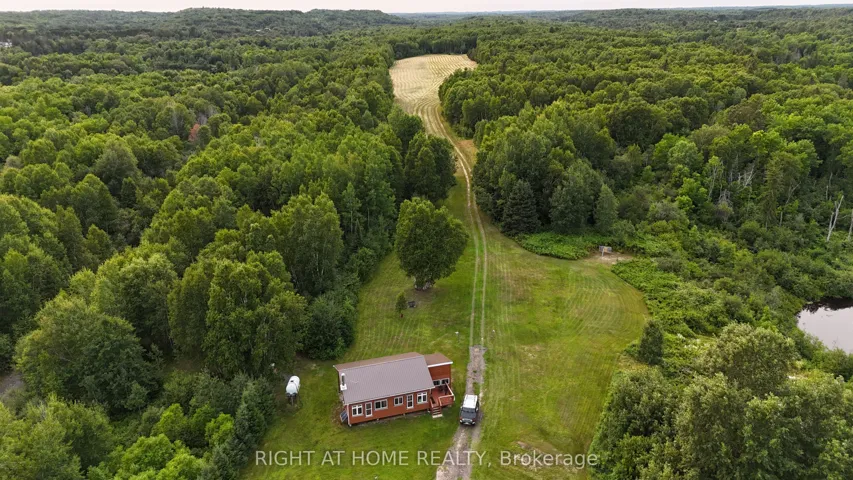
+"PublicRemarks": "Top 5 Reasons You Will Love This Property: 1) This property is ready for your summer build, with the seller willing to consider holding a VTB mortgage for added convenience 2) Set on a vast 6.57-acre lot surrounded by trees, it's the perfect place to build your dream home or a peaceful cottage retreat 3) Enjoy the benefits of a partially cleared area, complete with an installed culvert and driveway, saving you time and effort with hydro available at the property line, adding to the convenience of development 4) Survey documentation is readily accessible, giving you the essential details needed to start your project with confidence 5) Escape city life while staying close to Highway 400, essential amenities, and just minutes from Georgian Bay and local marinas, it's a paradise for boaters and water enthusiasts while the property is near Oakbay Golf Club, offering access to a golf course and restaurants, and just a short drive to local ski hills."
+"CityRegion": "Baxter"
+"CoListOfficeName": "Faris Team Real Estate Brokerage"
+"CoListOfficePhone": "705-527-1887"
+"Country": "CA"
+"CountyOrParish": "Muskoka"
+"CreationDate": "2025-09-02T19:01:46.537414+00:00"
+"CrossStreet": "Honey Harbour Rd/Musky Bay Rd"
+"DirectionFaces": "North"
+"Directions": "Honey Harbour Rd/Musky Bay Rd"
+"ExpirationDate": "2025-12-02"
+"InteriorFeatures": array:1 [
0 => "None"
]
+"RFTransactionType": "For Sale"
+"InternetEntireListingDisplayYN": true
+"ListAOR": "Toronto Regional Real Estate Board"
+"ListingContractDate": "2025-09-02"
+"MainOfficeKey": "239900"
+"MajorChangeTimestamp": "2025-09-02T18:58:50Z"
+"MlsStatus": "New"
+"OccupantType": "Vacant"
+"OriginalEntryTimestamp": "2025-09-02T18:58:50Z"
+"OriginalListPrice": 399900.0
+"OriginatingSystemID": "A00001796"
+"OriginatingSystemKey": "Draft2901016"
+"ParcelNumber": "480160492"
+"ParkingFeatures": array:1 [
0 => "None"
]
+"PhotosChangeTimestamp": "2025-09-02T18:58:50Z"
+"Sewer": array:1 [
0 => "None"
]
+"ShowingRequirements": array:1 [
0 => "List Brokerage"
]
+"SourceSystemID": "A00001796"
+"SourceSystemName": "Toronto Regional Real Estate Board"
+"StateOrProvince": "ON"
+"StreetName": "Musky Bay"
+"StreetNumber": "88"
+"StreetSuffix": "Road"
+"TaxAnnualAmount": "330.0"
+"TaxLegalDescription": "PT LT 34 CON 5 BAXTER PT 3 35R22901 TOWNSHIP OF GEORGIAN BAY"
+"TaxYear": "2024"
+"TransactionBrokerCompensation": "2.5%"
+"TransactionType": "For Sale"
+"VirtualTourURLBranded": "https://www.youtube.com/watch?v=DXkb Umpr-B4"
+"VirtualTourURLUnbranded": "https://youtu.be/7Ea9Fx9wvx4"
+"Zoning": "EP1/R1"
+"DDFYN": true
+"Water": "None"
+"GasYNA": "No"
+"CableYNA": "No"
+"LotDepth": 1712.0
+"LotWidth": 200.0
+"SewerYNA": "No"
+"WaterYNA": "No"
+"@odata.id": "https://api.realtyfeed.com/reso/odata/Property('X12375110')"
+"RollNumber": "446503001701230"
+"SurveyType": "Available"
+"Waterfront": array:1 [
0 => "None"
]
+"ElectricYNA": "Available"
+"HoldoverDays": 60
+"TelephoneYNA": "No"
+"provider_name": "TRREB"
+"ContractStatus": "Available"
+"HSTApplication": array:1 [
0 => "Included In"
]
+"PossessionType": "Immediate"
+"PriorMlsStatus": "Draft"
+"LivingAreaRange": "< 700"
+"LotSizeRangeAcres": "5-9.99"
+"PossessionDetails": "Immediate"
+"SpecialDesignation": array:1 [
0 => "Unknown"
]
+"ShowingAppointments": "TLO"
+"MediaChangeTimestamp": "2025-09-02T18:58:50Z"
+"SystemModificationTimestamp": "2025-09-21T15:17:22.671459Z"
+"Media": array:13 [
0 => array:26 [ …26]
1 => array:26 [ …26]
2 => array:26 [ …26]
3 => array:26 [ …26]
4 => array:26 [ …26]
5 => array:26 [ …26]
6 => array:26 [ …26]
7 => array:26 [ …26]
8 => array:26 [ …26]
9 => array:26 [ …26]
10 => array:26 [ …26]
11 => array:26 [ …26]
12 => array:26 [ …26]
]
}
1 => Realtyna\MlsOnTheFly\Components\CloudPost\SubComponents\RFClient\SDK\RF\Entities\RFProperty {#14854
+post_id: ? mixed
+post_author: ? mixed
+"ListingKey": "X12373792"
+"ListingId": "X12373792"
+"PropertyType": "Residential"
+"PropertySubType": "Vacant Land"
+"StandardStatus": "Active"
+"ModificationTimestamp": "2025-09-21T14:58:10Z"
+"RFModificationTimestamp": "2025-09-21T15:16:42Z"
+"ListPrice": 599900.0
+"BathroomsTotalInteger": 0
+"BathroomsHalf": 0
+"BedroomsTotal": 0
+"LotSizeArea": 13.5
+"LivingArea": 0
+"BuildingAreaTotal": 0
+"City": "Greater Napanee"
+"PostalCode": "K7R 3K7"
+"UnparsedAddress": "0 Third Concession Road, Greater Napanee, ON K7R 3K7"
+"Coordinates": array:2 [
0 => -77.0570806
1 => 44.0887687
]
+"Latitude": 44.0887687
+"Longitude": -77.0570806
+"YearBuilt": 0
+"InternetAddressDisplayYN": true
+"FeedTypes": "IDX"
+"ListOfficeName": "RE/MAX FINEST REALTY INC., BROKERAGE"
+"OriginatingSystemName": "TRREB"
+"PublicRemarks": "An exceptional opportunity awaits on 13.5 acres of scenic waterfront land, boasting 225 feet of frontage on sought-after Hay Bay. With expansive views overlooking Long Reach and Prince Edward County, this property offers both natural beauty and development potential. Whether you're dreaming of building a private estate, family retreat, or exploring the potential for a larger residential development, this parcel delivers space, privacy, and breathtaking surroundings. Located just minutes from Prince Edward County's renowned wineries, artisan markets, and culinary destinations, this property blends peaceful waterfront living with easy access to one of Ontario's most desirable regions. A rare combination of size, shoreline, and location. Perfect for visionaries, builders, and investors alike."
+"CityRegion": "58 - Greater Napanee"
+"CountyOrParish": "Lennox & Addington"
+"CreationDate": "2025-09-02T14:54:00.847624+00:00"
+"CrossStreet": "Third Concession and Willow Point"
+"DirectionFaces": "North"
+"Directions": "County Road 8 or Highway 33 to South Shore Road, to Third Concession. The property is just west of Willow Point Lane."
+"Disclosures": array:1 [
0 => "Environmentally Protected"
]
+"ExpirationDate": "2025-12-02"
+"InteriorFeatures": array:1 [
0 => "None"
]
+"RFTransactionType": "For Sale"
+"InternetEntireListingDisplayYN": true
+"ListAOR": "Kingston & Area Real Estate Association"
+"ListingContractDate": "2025-09-02"
+"MainOfficeKey": "470300"
+"MajorChangeTimestamp": "2025-09-02T14:33:54Z"
+"MlsStatus": "New"
+"OccupantType": "Vacant"
+"OriginalEntryTimestamp": "2025-09-02T14:33:54Z"
+"OriginalListPrice": 599900.0
+"OriginatingSystemID": "A00001796"
+"OriginatingSystemKey": "Draft2913560"
+"ParcelNumber": "451020920"
+"PhotosChangeTimestamp": "2025-09-02T14:33:54Z"
+"Sewer": array:1 [
0 => "None"
]
+"ShowingRequirements": array:1 [
0 => "Showing System"
]
+"SignOnPropertyYN": true
+"SourceSystemID": "A00001796"
+"SourceSystemName": "Toronto Regional Real Estate Board"
+"StateOrProvince": "ON"
+"StreetName": "Third Concession"
+"StreetNumber": "0"
+"StreetSuffix": "Road"
+"TaxAnnualAmount": "216.19"
+"TaxLegalDescription": "PT LT 21-22 CON 3 ADOLPHUSTOWN PT 2 29R1379 & AS IN LA221154 (THIRDLY); S/T & T/W LA221154 TOWN OF GREATER NAPANEE"
+"TaxYear": "2024"
+"TransactionBrokerCompensation": "2%"
+"TransactionType": "For Sale"
+"VirtualTourURLBranded": "https://www.youtube.com/watch?v=s Uim3g O0MFE"
+"VirtualTourURLUnbranded": "https://www.youtube.com/watch?v=s Uim3g O0MFE"
+"WaterBodyName": "Lake Ontario"
+"WaterfrontFeatures": array:1 [
0 => "Not Applicable"
]
+"WaterfrontYN": true
+"Zoning": "SR"
+"DDFYN": true
+"Water": "None"
+"GasYNA": "No"
+"CableYNA": "No"
+"LotDepth": 1219.17
+"LotWidth": 506.33
+"SewerYNA": "No"
+"WaterYNA": "No"
+"@odata.id": "https://api.realtyfeed.com/reso/odata/Property('X12373792')"
+"Shoreline": array:2 [
0 => "Clean"
1 => "Rocky"
]
+"WaterView": array:1 [
0 => "Direct"
]
+"RollNumber": "112116003029302"
+"SurveyType": "Unknown"
+"Waterfront": array:1 [
0 => "Direct"
]
+"ChannelName": "Hay Bay"
+"DockingType": array:1 [
0 => "None"
]
+"ElectricYNA": "Available"
+"HoldoverDays": 60
+"TelephoneYNA": "Available"
+"WaterBodyType": "Lake"
+"provider_name": "TRREB"
+"ContractStatus": "Available"
+"HSTApplication": array:1 [
0 => "Included In"
]
+"PossessionType": "Flexible"
+"PriorMlsStatus": "Draft"
+"LivingAreaRange": "< 700"
+"AccessToProperty": array:1 [
0 => "Private Road"
]
+"AlternativePower": array:1 [
0 => "Unknown"
]
+"LotSizeAreaUnits": "Acres"
+"PropertyFeatures": array:1 [
0 => "Lake/Pond"
]
+"LotSizeRangeAcres": "10-24.99"
+"PossessionDetails": "Flexible"
+"ShorelineAllowance": "Owned"
+"SpecialDesignation": array:1 [
0 => "Unknown"
]
+"WaterfrontAccessory": array:1 [
0 => "Not Applicable"
]
+"MediaChangeTimestamp": "2025-09-02T14:33:54Z"
+"SystemModificationTimestamp": "2025-09-21T14:58:10.431368Z"
+"PermissionToContactListingBrokerToAdvertise": true
+"Media": array:27 [
0 => array:26 [ …26]
1 => array:26 [ …26]
2 => array:26 [ …26]
3 => array:26 [ …26]
4 => array:26 [ …26]
5 => array:26 [ …26]
6 => array:26 [ …26]
7 => array:26 [ …26]
8 => array:26 [ …26]
9 => array:26 [ …26]
10 => array:26 [ …26]
11 => array:26 [ …26]
12 => array:26 [ …26]
13 => array:26 [ …26]
14 => array:26 [ …26]
15 => array:26 [ …26]
16 => array:26 [ …26]
17 => array:26 [ …26]
18 => array:26 [ …26]
19 => array:26 [ …26]
20 => array:26 [ …26]
21 => array:26 [ …26]
22 => array:26 [ …26]
23 => array:26 [ …26]
24 => array:26 [ …26]
25 => array:26 [ …26]
26 => array:26 [ …26]
]
}
2 => Realtyna\MlsOnTheFly\Components\CloudPost\SubComponents\RFClient\SDK\RF\Entities\RFProperty {#14787
+post_id: ? mixed
+post_author: ? mixed
+"ListingKey": "X12373766"
+"ListingId": "X12373766"
+"PropertyType": "Residential"
+"PropertySubType": "Vacant Land"
+"StandardStatus": "Active"
+"ModificationTimestamp": "2025-09-21T14:57:52Z"
+"RFModificationTimestamp": "2025-09-21T15:18:13Z"
+"ListPrice": 311000.0
+"BathroomsTotalInteger": 0
+"BathroomsHalf": 0
+"BedroomsTotal": 0
+"LotSizeArea": 0
+"LivingArea": 0
+"BuildingAreaTotal": 0
+"City": "Niagara Falls"
+"PostalCode": "L2H 0B8"
+"UnparsedAddress": "6172 Curlin Crescent, Niagara Falls, ON L2H 0B8"
+"Coordinates": array:2 [
0 => -79.0639039
1 => 43.1065603
]
+"Latitude": 43.1065603
+"Longitude": -79.0639039
+"YearBuilt": 0
+"InternetAddressDisplayYN": true
+"FeedTypes": "IDX"
+"ListOfficeName": "RE/MAX NIAGARA REALTY LTD, BROKERAGE"
+"OriginatingSystemName": "TRREB"
+"PublicRemarks": "Rare Find! A vacant residential lot with no builder contract! Build your own custom home in this highly sought after neighbourhood in Niagara Falls. Seller Financing is available for this piece of land with 25% down to help you build your dream home."
+"CityRegion": "219 - Forestview"
+"CountyOrParish": "Niagara"
+"CreationDate": "2025-09-02T14:58:02.724750+00:00"
+"CrossStreet": "Angie Dr"
+"DirectionFaces": "North"
+"Directions": "Garner Rd to Angie Dr"
+"ExpirationDate": "2026-02-28"
+"RFTransactionType": "For Sale"
+"InternetEntireListingDisplayYN": true
+"ListAOR": "Niagara Association of REALTORS"
+"ListingContractDate": "2025-09-02"
+"MainOfficeKey": "322300"
+"MajorChangeTimestamp": "2025-09-02T14:28:23Z"
+"MlsStatus": "New"
+"OccupantType": "Vacant"
+"OriginalEntryTimestamp": "2025-09-02T14:28:23Z"
+"OriginalListPrice": 311000.0
+"OriginatingSystemID": "A00001796"
+"OriginatingSystemKey": "Draft2921926"
+"PhotosChangeTimestamp": "2025-09-03T15:54:54Z"
+"ShowingRequirements": array:1 [
0 => "Go Direct"
]
+"SignOnPropertyYN": true
+"SourceSystemID": "A00001796"
+"SourceSystemName": "Toronto Regional Real Estate Board"
+"StateOrProvince": "ON"
+"StreetName": "Curlin"
+"StreetNumber": "6172"
+"StreetSuffix": "Crescent"
+"TaxAnnualAmount": "1351.4"
+"TaxAssessedValue": 81000
+"TaxLegalDescription": "LOT 16, PLAN 59M510 SUBJECT TO AN EASEMENT OVER PART 11 PLAN 59R17520 AS IN SN753855 SUBJECT TO AN EASEMENT FOR ENTRY AS IN SN757445 CITY OF NIAGARA FALLS"
+"TaxYear": "2025"
+"TransactionBrokerCompensation": "2"
+"TransactionType": "For Sale"
+"Zoning": "R1F-1153"
+"DDFYN": true
+"GasYNA": "Available"
+"CableYNA": "Available"
+"LotDepth": 101.87
+"LotWidth": 31.27
+"SewerYNA": "Available"
+"WaterYNA": "Available"
+"@odata.id": "https://api.realtyfeed.com/reso/odata/Property('X12373766')"
+"SurveyType": "Available"
+"Waterfront": array:1 [
0 => "None"
]
+"ElectricYNA": "Available"
+"HoldoverDays": 60
+"TelephoneYNA": "Available"
+"provider_name": "TRREB"
+"AssessmentYear": 2025
+"ContractStatus": "Available"
+"HSTApplication": array:1 [
0 => "In Addition To"
]
+"PossessionType": "Flexible"
+"PriorMlsStatus": "Draft"
+"MortgageComment": "Seller Financing Available"
+"LotSizeRangeAcres": "< .50"
+"PossessionDetails": "30-60"
+"SpecialDesignation": array:1 [
0 => "Unknown"
]
+"MediaChangeTimestamp": "2025-09-03T15:54:54Z"
+"SystemModificationTimestamp": "2025-09-21T14:57:52.33604Z"
+"PermissionToContactListingBrokerToAdvertise": true
+"Media": array:4 [
0 => array:26 [ …26]
1 => array:26 [ …26]
2 => array:26 [ …26]
3 => array:26 [ …26]
]
}
3 => Realtyna\MlsOnTheFly\Components\CloudPost\SubComponents\RFClient\SDK\RF\Entities\RFProperty {#14853
+post_id: ? mixed
+post_author: ? mixed
+"ListingKey": "X12373611"
+"ListingId": "X12373611"
+"PropertyType": "Residential"
+"PropertySubType": "Vacant Land"
+"StandardStatus": "Active"
+"ModificationTimestamp": "2025-09-21T14:55:15Z"
+"RFModificationTimestamp": "2025-09-21T15:12:22Z"
+"ListPrice": 299000.0
+"BathroomsTotalInteger": 0
+"BathroomsHalf": 0
+"BedroomsTotal": 0
+"LotSizeArea": 29.979
+"LivingArea": 0
+"BuildingAreaTotal": 0
+"City": "Lanark Highlands"
+"PostalCode": "K0G 1K0"
+"UnparsedAddress": "1477 Watsons Corners Road, Lanark Highlands, ON K0G 1K0"
+"Coordinates": array:2 [
0 => -76.413124
1 => 45.0502312
]
+"Latitude": 45.0502312
+"Longitude": -76.413124
+"YearBuilt": 0
+"InternetAddressDisplayYN": true
+"FeedTypes": "IDX"
+"ListOfficeName": "ROYAL LEPAGE TEAM REALTY"
+"OriginatingSystemName": "TRREB"
+"PublicRemarks": "This 30-acre property welcomes you with a newly installed culvert and driveway guiding you into nature's masterpiece that is sure to inspire. This stunning acreage boasts mature red pine trees, creating a majestic canopy over the landscape. Diverse foliage includes maples, birch, and a variety of evergreens, adding vibrancy to the surroundings. The rolling hills lend character to the terrain, providing picturesque views and potential building sites. The property's whimsical feel invites exploration, with meandering pathways leading through the enchanting landscape. Bordered by natural ponds, the land seamlessly integrates with the water's edge, attracting local wildlife. Embrace the charm of the red pine forest, the variety of trees and the gentle hills."
+"CityRegion": "913 - Lanark Highlands (Lanark) Twp"
+"CoListOfficeName": "ROYAL LEPAGE TEAM REALTY"
+"CoListOfficePhone": "613-831-9287"
+"CountyOrParish": "Lanark"
+"CreationDate": "2025-09-02T14:07:25.836467+00:00"
+"CrossStreet": "HWY 511 & Watsons Corners Road"
+"DirectionFaces": "South"
+"Directions": "HWY 511 to Watsons Corners Road. The property is on the left."
+"ExpirationDate": "2026-01-06"
+"RFTransactionType": "For Sale"
+"InternetEntireListingDisplayYN": true
+"ListAOR": "Ottawa Real Estate Board"
+"ListingContractDate": "2025-09-02"
+"LotSizeSource": "Geo Warehouse"
+"MainOfficeKey": "506800"
+"MajorChangeTimestamp": "2025-09-02T14:00:40Z"
+"MlsStatus": "New"
+"OccupantType": "Vacant"
+"OriginalEntryTimestamp": "2025-09-02T14:00:40Z"
+"OriginalListPrice": 299000.0
+"OriginatingSystemID": "A00001796"
+"OriginatingSystemKey": "Draft2916988"
+"ParcelNumber": "050430214"
+"PhotosChangeTimestamp": "2025-09-02T14:00:40Z"
+"ShowingRequirements": array:1 [
0 => "Showing System"
]
+"SourceSystemID": "A00001796"
+"SourceSystemName": "Toronto Regional Real Estate Board"
+"StateOrProvince": "ON"
+"StreetName": "Watsons Corners"
+"StreetNumber": "1477"
+"StreetSuffix": "Road"
+"TaxAnnualAmount": "1036.21"
+"TaxLegalDescription": "PT OF LT 10 CON 2 LANARK BEING PART 1 ON PL 27R10529 TOWNSHIP OF LANARK HIGHLANDS"
+"TaxYear": "2024"
+"TransactionBrokerCompensation": "2.5"
+"TransactionType": "For Sale"
+"View": array:3 [
0 => "Forest"
1 => "Trees/Woods"
2 => "Hills"
]
+"Zoning": "RU"
+"DDFYN": true
+"GasYNA": "No"
+"CableYNA": "No"
+"LotDepth": 1506.39
+"LotShape": "Rectangular"
+"LotWidth": 842.31
+"SewerYNA": "No"
+"WaterYNA": "No"
+"@odata.id": "https://api.realtyfeed.com/reso/odata/Property('X12373611')"
+"RollNumber": "94093401011202"
+"SurveyType": "None"
+"Waterfront": array:1 [
0 => "None"
]
+"ElectricYNA": "Available"
+"HoldoverDays": 60
+"TelephoneYNA": "Available"
+"provider_name": "TRREB"
+"ContractStatus": "Available"
+"HSTApplication": array:1 [
0 => "Included In"
]
+"PossessionType": "Immediate"
+"PriorMlsStatus": "Draft"
+"LotSizeAreaUnits": "Acres"
+"LotSizeRangeAcres": "25-49.99"
+"PossessionDetails": "Flexible"
+"SpecialDesignation": array:1 [
0 => "Unknown"
]
+"MediaChangeTimestamp": "2025-09-02T14:00:40Z"
+"SystemModificationTimestamp": "2025-09-21T14:55:15.479665Z"
+"PermissionToContactListingBrokerToAdvertise": true
+"Media": array:14 [
0 => array:26 [ …26]
1 => array:26 [ …26]
2 => array:26 [ …26]
3 => array:26 [ …26]
4 => array:26 [ …26]
5 => array:26 [ …26]
6 => array:26 [ …26]
7 => array:26 [ …26]
8 => array:26 [ …26]
9 => array:26 [ …26]
10 => array:26 [ …26]
11 => array:26 [ …26]
12 => array:26 [ …26]
13 => array:26 [ …26]
]
}
4 => Realtyna\MlsOnTheFly\Components\CloudPost\SubComponents\RFClient\SDK\RF\Entities\RFProperty {#14852
+post_id: ? mixed
+post_author: ? mixed
+"ListingKey": "X12373198"
+"ListingId": "X12373198"
+"PropertyType": "Residential"
+"PropertySubType": "Vacant Land"
+"StandardStatus": "Active"
+"ModificationTimestamp": "2025-09-21T14:49:01Z"
+"RFModificationTimestamp": "2025-09-21T14:52:32Z"
+"ListPrice": 397500.0
+"BathroomsTotalInteger": 0
+"BathroomsHalf": 0
+"BedroomsTotal": 0
+"LotSizeArea": 0
+"LivingArea": 0
+"BuildingAreaTotal": 0
+"City": "Kingston"
+"PostalCode": "K7P 2Z4"
+"UnparsedAddress": "3048 Creekford Road, Kingston, ON K7P 2Z4"
+"Coordinates": array:2 [
0 => -76.5969967
1 => 44.2786419
]
+"Latitude": 44.2786419
+"Longitude": -76.5969967
+"YearBuilt": 0
+"InternetAddressDisplayYN": true
+"FeedTypes": "IDX"
+"ListOfficeName": "ROYAL LEPAGE PROALLIANCE REALTY, BROKERAGE"
+"OriginatingSystemName": "TRREB"
+"PublicRemarks": "2.5 Acre Building Lot on Creekford Road. Country in the City!! Large Mature Trees. Drilled Well yielding 10 GPM. Full House plans, Plot Plan & Land Survey available. HST has been paid."
+"Basement": array:1 [
0 => "Unfinished"
]
+"CityRegion": "42 - City Northwest"
+"CoListOfficeName": "ROYAL LEPAGE PROALLIANCE REALTY, BROKERAGE"
+"CoListOfficePhone": "613-384-1200"
+"Country": "CA"
+"CountyOrParish": "Frontenac"
+"CreationDate": "2025-09-02T11:48:54.478870+00:00"
+"CrossStreet": "Bayridge Drive"
+"DirectionFaces": "North"
+"Directions": "From Gardiners Road, East on Creekford"
+"ExpirationDate": "2025-12-15"
+"InteriorFeatures": array:1 [
0 => "None"
]
+"RFTransactionType": "For Sale"
+"InternetEntireListingDisplayYN": true
+"ListAOR": "Kingston & Area Real Estate Association"
+"ListingContractDate": "2025-09-02"
+"MainOfficeKey": "179000"
+"MajorChangeTimestamp": "2025-09-02T11:43:58Z"
+"MlsStatus": "New"
+"OccupantType": "Vacant"
+"OriginalEntryTimestamp": "2025-09-02T11:43:58Z"
+"OriginalListPrice": 397500.0
+"OriginatingSystemID": "A00001796"
+"OriginatingSystemKey": "Draft2922972"
+"ParcelNumber": "361290544"
+"PhotosChangeTimestamp": "2025-09-02T11:43:59Z"
+"Sewer": array:1 [
0 => "Septic"
]
+"ShowingRequirements": array:1 [
0 => "Showing System"
]
+"SignOnPropertyYN": true
+"SourceSystemID": "A00001796"
+"SourceSystemName": "Toronto Regional Real Estate Board"
+"StateOrProvince": "ON"
+"StreetName": "Creekford"
+"StreetNumber": "3048"
+"StreetSuffix": "Road"
+"TaxAnnualAmount": "1600.0"
+"TaxLegalDescription": "PART LOT 5, CONCESSION 4 KINGSTON, PART 2, PLAN 13R22966 CITY OF KINGSTON"
+"TaxYear": "2025"
+"TransactionBrokerCompensation": "2.0%"
+"TransactionType": "For Sale"
+"DDFYN": true
+"Water": "Well"
+"GasYNA": "No"
+"CableYNA": "Available"
+"LotDepth": 556.7
+"LotWidth": 196.81
+"SewerYNA": "No"
+"WaterYNA": "No"
+"@odata.id": "https://api.realtyfeed.com/reso/odata/Property('X12373198')"
+"SurveyType": "Available"
+"Waterfront": array:1 [
0 => "None"
]
+"ElectricYNA": "Available"
+"TelephoneYNA": "Available"
+"provider_name": "TRREB"
+"ContractStatus": "Available"
+"HSTApplication": array:1 [
0 => "Included In"
]
+"PossessionDate": "2025-09-30"
+"PossessionType": "Flexible"
+"PriorMlsStatus": "Draft"
+"LivingAreaRange": "< 700"
+"LotSizeRangeAcres": "2-4.99"
+"SpecialDesignation": array:1 [
0 => "Unknown"
]
+"MediaChangeTimestamp": "2025-09-02T11:43:59Z"
+"SystemModificationTimestamp": "2025-09-21T14:49:01.443125Z"
+"PermissionToContactListingBrokerToAdvertise": true
+"Media": array:7 [
0 => array:26 [ …26]
1 => array:26 [ …26]
2 => array:26 [ …26]
3 => array:26 [ …26]
4 => array:26 [ …26]
5 => array:26 [ …26]
6 => array:26 [ …26]
]
}
5 => Realtyna\MlsOnTheFly\Components\CloudPost\SubComponents\RFClient\SDK\RF\Entities\RFProperty {#14865
+post_id: ? mixed
+post_author: ? mixed
+"ListingKey": "X12373163"
+"ListingId": "X12373163"
+"PropertyType": "Residential"
+"PropertySubType": "Vacant Land"
+"StandardStatus": "Active"
+"ModificationTimestamp": "2025-09-21T14:48:43Z"
+"RFModificationTimestamp": "2025-09-21T14:52:32Z"
+"ListPrice": 165000.0
+"BathroomsTotalInteger": 0
+"BathroomsHalf": 0
+"BedroomsTotal": 0
+"LotSizeArea": 2.575
+"LivingArea": 0
+"BuildingAreaTotal": 0
+"City": "Kearney"
+"PostalCode": "P0A 1M0"
+"UnparsedAddress": "Lot 2 Riverside Drive, Kearney, ON P0A 1M0"
+"Coordinates": array:2 [
0 => -79.2240995
1 => 45.5554837
]
+"Latitude": 45.5554837
+"Longitude": -79.2240995
+"YearBuilt": 0
+"InternetAddressDisplayYN": true
+"FeedTypes": "IDX"
+"ListOfficeName": "Royal Le Page Lakes Of Muskoka Realty"
+"OriginatingSystemName": "TRREB"
+"PublicRemarks": "Nestled at the end of a year round municipal road adding to your privacy this beautifully treed lot with a driveway already installed spans a generous 2.57 acres. Located in an area of exclusive homes and cottages this level lot is a blank slate for your dream home and your imagination. A short drive away lies the quaint village of Kearney where you can enjoy charming amenities like locally owned restaurants and a warm, welcoming community atmosphere. The area boasts a public beach nearby and an abundance of smaller lakes and lake chains which are perfect to explore by boat, canoe, or kayak. For more outdoor adventures world renowned Algonquin Park is close by as well offering an escape to the wilderness. Living in this area easily lets you escape the hustle and bustle of city life and allows a tranquil retreat at the end of the day. Easy access to the highway for a commuter working in the neighbouring towns and villages. Easy access to the lot when you're ready to build. A VTB (Vendor Take Back Mortgage) is possible depending on approved, negotiated terms."
+"CityRegion": "Kearney"
+"CountyOrParish": "Parry Sound"
+"CreationDate": "2025-09-02T11:17:35.401073+00:00"
+"CrossStreet": "Main Street/Lakeview Ave"
+"DirectionFaces": "South"
+"Directions": "Highway 518 East to Main Street (Kearney) to Lakeview to Riverside"
+"ExpirationDate": "2025-11-29"
+"InteriorFeatures": array:1 [
0 => "None"
]
+"RFTransactionType": "For Sale"
+"InternetEntireListingDisplayYN": true
+"ListAOR": "One Point Association of REALTORS"
+"ListingContractDate": "2025-08-29"
+"LotSizeSource": "Survey"
+"MainOfficeKey": "557500"
+"MajorChangeTimestamp": "2025-09-02T11:14:19Z"
+"MlsStatus": "New"
+"OccupantType": "Vacant"
+"OriginalEntryTimestamp": "2025-09-02T11:14:19Z"
+"OriginalListPrice": 165000.0
+"OriginatingSystemID": "A00001796"
+"OriginatingSystemKey": "Draft2913784"
+"OtherStructures": array:1 [
0 => "None"
]
+"ParcelNumber": "521580404"
+"PhotosChangeTimestamp": "2025-09-02T14:34:15Z"
+"PoolFeatures": array:1 [
0 => "None"
]
+"SecurityFeatures": array:1 [
0 => "None"
]
+"Sewer": array:1 [
0 => "None"
]
+"ShowingRequirements": array:1 [
0 => "Showing System"
]
+"SourceSystemID": "A00001796"
+"SourceSystemName": "Toronto Regional Real Estate Board"
+"StateOrProvince": "ON"
+"StreetName": "Riverside"
+"StreetNumber": "Lot 2"
+"StreetSuffix": "Drive"
+"TaxAssessedValue": 25000
+"TaxLegalDescription": "PT 2 PL 42R22508; TOWN OF KEARNEY, DISTRICT PARRY SOUND"
+"TaxYear": "2025"
+"Topography": array:3 [
0 => "Flat"
1 => "Level"
2 => "Wooded/Treed"
]
+"TransactionBrokerCompensation": "2.5% + HST"
+"TransactionType": "For Sale"
+"View": array:2 [
0 => "Trees/Woods"
1 => "Forest"
]
+"DDFYN": true
+"Water": "None"
+"GasYNA": "No"
+"CableYNA": "No"
+"LotDepth": 250.84
+"LotWidth": 66.92
+"SewerYNA": "No"
+"WaterYNA": "No"
+"@odata.id": "https://api.realtyfeed.com/reso/odata/Property('X12373163')"
+"RollNumber": "491802000723613"
+"SurveyType": "Boundary Only"
+"Waterfront": array:1 [
0 => "None"
]
+"ElectricYNA": "Yes"
+"HoldoverDays": 60
+"TelephoneYNA": "Available"
+"provider_name": "TRREB"
+"AssessmentYear": 2025
+"ContractStatus": "Available"
+"HSTApplication": array:1 [
0 => "In Addition To"
]
+"PossessionType": "Flexible"
+"PriorMlsStatus": "Draft"
+"LivingAreaRange": "< 700"
+"LotSizeAreaUnits": "Acres"
+"PropertyFeatures": array:4 [
0 => "Beach"
1 => "Level"
2 => "Place Of Worship"
3 => "Wooded/Treed"
]
+"LotSizeRangeAcres": "2-4.99"
+"PossessionDetails": "Flexible"
+"SpecialDesignation": array:1 [
0 => "Other"
]
+"MediaChangeTimestamp": "2025-09-02T14:34:15Z"
+"SystemModificationTimestamp": "2025-09-21T14:48:43.347963Z"
+"PermissionToContactListingBrokerToAdvertise": true
+"Media": array:9 [
0 => array:26 [ …26]
1 => array:26 [ …26]
2 => array:26 [ …26]
3 => array:26 [ …26]
4 => array:26 [ …26]
5 => array:26 [ …26]
6 => array:26 [ …26]
7 => array:26 [ …26]
8 => array:26 [ …26]
]
}
6 => Realtyna\MlsOnTheFly\Components\CloudPost\SubComponents\RFClient\SDK\RF\Entities\RFProperty {#14866
+post_id: ? mixed
+post_author: ? mixed
+"ListingKey": "X12372396"
+"ListingId": "X12372396"
+"PropertyType": "Residential"
+"PropertySubType": "Vacant Land"
+"StandardStatus": "Active"
+"ModificationTimestamp": "2025-09-21T14:41:28Z"
+"RFModificationTimestamp": "2025-09-21T14:45:04Z"
+"ListPrice": 149000.0
+"BathroomsTotalInteger": 0
+"BathroomsHalf": 0
+"BedroomsTotal": 0
+"LotSizeArea": 48.33
+"LivingArea": 0
+"BuildingAreaTotal": 0
+"City": "Lanark Highlands"
+"PostalCode": "K0G 1K0"
+"UnparsedAddress": "0 Reids Road, Lanark Highlands, ON K0G 1K0"
+"Coordinates": array:2 [
0 => -76.6530474
1 => 45.0698799
]
+"Latitude": 45.0698799
+"Longitude": -76.6530474
+"YearBuilt": 0
+"InternetAddressDisplayYN": true
+"FeedTypes": "IDX"
+"ListOfficeName": "HOMES & COTTAGES UNLIMITED REALTY INC."
+"OriginatingSystemName": "TRREB"
+"PublicRemarks": "50 Acres Hardcore Hunting & ATV Base Camp Serious outdoorsmen, this is the one youve been waiting for. 50 acres of raw, rugged land built for hunting, ATVing, and backwoods adventure. A cleared ATV trail runs in off the road allowance (with a short stretch across crown land), giving you direct access to your own private wilderness playground.This property is loaded with wildlifebear, deer, and wild turkeys are all here. With 2,500 acres of crown land on three sides, youll never run out of space to hunt, scout, or ride. Drop a hunt camp, set up blinds, and track game straight from your doorstep.For riders, this is prime territory. Blaze the existing ATV trail, cut new lines, or push straight into crown for endless backwoods riding. In the winter, switch gears and run your sleds right from camp.There are three ponds on site, not subject to MVCA regulations, so you can use them without red tape. Just minutes from a Township Road, but once youre in, youre off the grid and in the bush where you belong.GPS corners (1.1m accuracy):North: 45.07553, -76.66019East: 45.07345, -76.65777South: 45.06962, -76.66394West: 45.07171, -76.66642(All but the far west corner are marked on the nearest tree.)This isnt a hobby lotits a serious hunting and ATV property surrounded by crown. The kind of ground that doesnt hit the market often."
+"CityRegion": "913 - Lanark Highlands (Lanark) Twp"
+"CountyOrParish": "Lanark"
+"CreationDate": "2025-08-31T23:50:04.702926+00:00"
+"CrossStreet": "South Lavant Road/Reids"
+"DirectionFaces": "South"
+"Directions": "Hwy 511 onto South Lavant Road. Follow to Reid's Road. Take trail that begins at the bend in the road on the left hand side."
+"ExpirationDate": "2025-12-31"
+"RFTransactionType": "For Sale"
+"InternetEntireListingDisplayYN": true
+"ListAOR": "Ottawa Real Estate Board"
+"ListingContractDate": "2025-08-31"
+"LotSizeSource": "Geo Warehouse"
+"MainOfficeKey": "491600"
+"MajorChangeTimestamp": "2025-08-31T23:45:29Z"
+"MlsStatus": "New"
+"OccupantType": "Vacant"
+"OriginalEntryTimestamp": "2025-08-31T23:45:29Z"
+"OriginalListPrice": 149000.0
+"OriginatingSystemID": "A00001796"
+"OriginatingSystemKey": "Draft2920638"
+"ParcelNumber": "050090002"
+"PhotosChangeTimestamp": "2025-08-31T23:45:29Z"
+"ShowingRequirements": array:1 [
0 => "List Salesperson"
]
+"SignOnPropertyYN": true
+"SourceSystemID": "A00001796"
+"SourceSystemName": "Toronto Regional Real Estate Board"
+"StateOrProvince": "ON"
+"StreetName": "Reids"
+"StreetNumber": "0"
+"StreetSuffix": "Road"
+"TaxAnnualAmount": "575.92"
+"TaxLegalDescription": "Pt Lt 8 Con 8 Lavant as in RN56337;Twp of Lanark Higlands"
+"TaxYear": "2025"
+"Topography": array:6 [
0 => "Wooded/Treed"
1 => "Rolling"
2 => "Rocky"
3 => "Marsh"
4 => "Hilly"
5 => "Dry"
]
+"TransactionBrokerCompensation": "2%"
+"TransactionType": "For Sale"
+"DDFYN": true
+"GasYNA": "No"
+"CableYNA": "No"
+"LotDepth": 2130.0
+"LotWidth": 985.31
+"SewerYNA": "No"
+"WaterYNA": "No"
+"@odata.id": "https://api.realtyfeed.com/reso/odata/Property('X12372396')"
+"RollNumber": "9400010150960"
+"SurveyType": "None"
+"Waterfront": array:1 [
0 => "None"
]
+"ElectricYNA": "No"
+"HoldoverDays": 60
+"TelephoneYNA": "No"
+"WaterBodyType": "Pond"
+"provider_name": "TRREB"
+"ContractStatus": "Available"
+"HSTApplication": array:1 [
0 => "Not Subject to HST"
]
+"PossessionType": "Immediate"
+"PriorMlsStatus": "Draft"
+"AccessToProperty": array:2 [
0 => "ATV/4 WD Only"
1 => "R.O.W. (Deeded)"
]
+"LotSizeAreaUnits": "Acres"
+"ParcelOfTiedLand": "No"
+"LotSizeRangeAcres": "50-99.99"
+"PossessionDetails": "Immediate"
+"ShorelineAllowance": "None"
+"SpecialDesignation": array:1 [
0 => "Unknown"
]
+"MediaChangeTimestamp": "2025-08-31T23:45:29Z"
+"SystemModificationTimestamp": "2025-09-21T14:41:28.965008Z"
+"Media": array:29 [
0 => array:26 [ …26]
1 => array:26 [ …26]
2 => array:26 [ …26]
3 => array:26 [ …26]
4 => array:26 [ …26]
5 => array:26 [ …26]
6 => array:26 [ …26]
7 => array:26 [ …26]
8 => array:26 [ …26]
9 => array:26 [ …26]
10 => array:26 [ …26]
11 => array:26 [ …26]
12 => array:26 [ …26]
13 => array:26 [ …26]
14 => array:26 [ …26]
15 => array:26 [ …26]
16 => array:26 [ …26]
17 => array:26 [ …26]
18 => array:26 [ …26]
19 => array:26 [ …26]
20 => array:26 [ …26]
21 => array:26 [ …26]
22 => array:26 [ …26]
23 => array:26 [ …26]
24 => array:26 [ …26]
25 => array:26 [ …26]
26 => array:26 [ …26]
27 => array:26 [ …26]
28 => array:26 [ …26]
]
}
7 => Realtyna\MlsOnTheFly\Components\CloudPost\SubComponents\RFClient\SDK\RF\Entities\RFProperty {#14869
+post_id: ? mixed
+post_author: ? mixed
+"ListingKey": "X12372317"
+"ListingId": "X12372317"
+"PropertyType": "Residential"
+"PropertySubType": "Vacant Land"
+"StandardStatus": "Active"
+"ModificationTimestamp": "2025-09-21T14:40:28Z"
+"RFModificationTimestamp": "2025-09-21T14:45:04Z"
+"ListPrice": 97000.0
+"BathroomsTotalInteger": 0
+"BathroomsHalf": 0
+"BedroomsTotal": 0
+"LotSizeArea": 0
+"LivingArea": 0
+"BuildingAreaTotal": 0
+"City": "Owen Sound"
+"PostalCode": "N4K 2L1"
+"UnparsedAddress": "1081 3rd A Avenue E, Owen Sound, ON N4K 2L1"
+"Coordinates": array:2 [
0 => -80.9404159
1 => 44.5692866
]
+"Latitude": 44.5692866
+"Longitude": -80.9404159
+"YearBuilt": 0
+"InternetAddressDisplayYN": true
+"FeedTypes": "IDX"
+"ListOfficeName": "i Cloud Realty Ltd."
+"OriginatingSystemName": "TRREB"
+"PublicRemarks": "Cheap Vacant Land Opportunity! Close to downtown and public transit. Purchase this land together with 1083 3rd A Ave East & 1085 3rd Ave A East for $798,000. Buyer and buyer's agent to perform all due diligence. Please do not walk on land without representation. HST is in addition too."
+"CityRegion": "Owen Sound"
+"Country": "CA"
+"CountyOrParish": "Grey County"
+"CreationDate": "2025-08-31T19:19:07.881028+00:00"
+"CrossStreet": "3rd Ave. A East & 11th St E"
+"DirectionFaces": "East"
+"Directions": "3rd Ave. A East & 11th St E"
+"ExpirationDate": "2026-02-28"
+"RFTransactionType": "For Sale"
+"InternetEntireListingDisplayYN": true
+"ListAOR": "Toronto Regional Real Estate Board"
+"ListingContractDate": "2025-08-29"
+"LotDimensionsSource": "Other"
+"LotSizeDimensions": "18.95 x 93.40 Feet"
+"LotSizeSource": "Other"
+"MainOfficeKey": "20015500"
+"MajorChangeTimestamp": "2025-08-31T19:14:16Z"
+"MlsStatus": "New"
+"OccupantType": "Vacant"
+"OriginalEntryTimestamp": "2025-08-31T19:14:16Z"
+"OriginalListPrice": 97000.0
+"OriginatingSystemID": "A00001796"
+"OriginatingSystemKey": "Draft2917452"
+"ParcelNumber": "370550148"
+"PhotosChangeTimestamp": "2025-09-01T16:56:07Z"
+"Sewer": array:1 [
0 => "None"
]
+"ShowingRequirements": array:2 [
0 => "Showing System"
1 => "List Brokerage"
]
+"SourceSystemID": "A00001796"
+"SourceSystemName": "Toronto Regional Real Estate Board"
+"StateOrProvince": "ON"
+"StreetDirSuffix": "E"
+"StreetName": "3rd A"
+"StreetNumber": "1081"
+"StreetSuffix": "Avenue"
+"TaxAnnualAmount": "601.71"
+"TaxBookNumber": "425901000108200"
+"TaxLegalDescription": "Pt Lt 3 E/S Lepan St Pl 39 Owen Sound As In R28325"
+"TaxYear": "2024"
+"TransactionBrokerCompensation": "2.25% plus HST"
+"TransactionType": "For Sale"
+"DDFYN": true
+"Water": "None"
+"GasYNA": "No"
+"CableYNA": "No"
+"LotDepth": 93.4
+"LotWidth": 18.95
+"SewerYNA": "No"
+"WaterYNA": "No"
+"@odata.id": "https://api.realtyfeed.com/reso/odata/Property('X12372317')"
+"PictureYN": true
+"RollNumber": "425901000108200"
+"SurveyType": "Unknown"
+"Waterfront": array:1 [
0 => "None"
]
+"ElectricYNA": "No"
+"HoldoverDays": 30
+"TelephoneYNA": "Available"
+"provider_name": "TRREB"
+"ContractStatus": "Available"
+"HSTApplication": array:1 [
0 => "Included In"
]
+"PossessionType": "Flexible"
+"PriorMlsStatus": "Draft"
+"PropertyFeatures": array:6 [
0 => "Hospital"
1 => "Library"
2 => "Park"
3 => "Place Of Worship"
4 => "Public Transit"
5 => "Rec./Commun.Centre"
]
+"BoardPropertyType": "Free"
+"LotSizeRangeAcres": "< .50"
+"PossessionDetails": "TBA"
+"SpecialDesignation": array:1 [
0 => "Unknown"
]
+"MediaChangeTimestamp": "2025-09-01T16:56:07Z"
+"MLSAreaDistrictOldZone": "X16"
+"MLSAreaMunicipalityDistrict": "Owen Sound"
+"SystemModificationTimestamp": "2025-09-21T14:40:28.640679Z"
+"PermissionToContactListingBrokerToAdvertise": true
+"Media": array:3 [
0 => array:26 [ …26]
1 => array:26 [ …26]
2 => array:26 [ …26]
]
}
8 => Realtyna\MlsOnTheFly\Components\CloudPost\SubComponents\RFClient\SDK\RF\Entities\RFProperty {#14867
+post_id: ? mixed
+post_author: ? mixed
+"ListingKey": "X12372030"
+"ListingId": "X12372030"
+"PropertyType": "Residential"
+"PropertySubType": "Vacant Land"
+"StandardStatus": "Active"
+"ModificationTimestamp": "2025-09-21T14:37:21Z"
+"RFModificationTimestamp": "2025-09-21T14:40:52Z"
+"ListPrice": 999999.0
+"BathroomsTotalInteger": 0
+"BathroomsHalf": 0
+"BedroomsTotal": 0
+"LotSizeArea": 0
+"LivingArea": 0
+"BuildingAreaTotal": 0
+"City": "Hamilton"
+"PostalCode": "L0R 2H1"
+"UnparsedAddress": "559 Dundas Street E, Hamilton, ON L0R 2H1"
+"Coordinates": array:2 [
0 => -79.8718608
1 => 43.3499742
]
+"Latitude": 43.3499742
+"Longitude": -79.8718608
+"YearBuilt": 0
+"InternetAddressDisplayYN": true
+"FeedTypes": "IDX"
+"ListOfficeName": "RE/MAX HALLMARK REALTY LTD."
+"OriginatingSystemName": "TRREB"
+"PublicRemarks": "Prime Development Opportunity In The Heart Of Waterdown! Offering Exceptional Exposure On Dundas Street East, This Rare Vacant Lot Features Approx. 92 Ft Frontage By 200 Ft Depth (0.42 Acres). Surrounded By Established And New Residential Communities, Schools, Parks, And Amenities. Excellent Potential To Build A Custom Home Or Explore Future Development (Buyer To Do Own Due Diligence On Zoning/Permits). Easy Access To Hwy 403, 407 & QEW."
+"CityRegion": "Waterdown"
+"CoListOfficeName": "RE/MAX HALLMARK REALTY LTD."
+"CoListOfficePhone": "905-883-4922"
+"Country": "CA"
+"CountyOrParish": "Hamilton"
+"CreationDate": "2025-08-31T00:40:37.157178+00:00"
+"CrossStreet": "Evans Rd & Dundas St"
+"DirectionFaces": "South"
+"Directions": "Evans Rd and Dundas Street East."
+"ExpirationDate": "2025-11-30"
+"RFTransactionType": "For Sale"
+"InternetEntireListingDisplayYN": true
+"ListAOR": "Toronto Regional Real Estate Board"
+"ListingContractDate": "2025-08-30"
+"LotDimensionsSource": "Other"
+"LotSizeDimensions": "92.42 x 200.00 Feet"
+"LotSizeSource": "Other"
+"MainOfficeKey": "259000"
+"MajorChangeTimestamp": "2025-08-31T00:37:06Z"
+"MlsStatus": "New"
+"OccupantType": "Owner"
+"OriginalEntryTimestamp": "2025-08-31T00:37:06Z"
+"OriginalListPrice": 999999.0
+"OriginatingSystemID": "A00001796"
+"OriginatingSystemKey": "Draft2920204"
+"ParcelNumber": "175020026"
+"PhotosChangeTimestamp": "2025-08-31T18:03:26Z"
+"Sewer": array:1 [
0 => "Septic"
]
+"ShowingRequirements": array:1 [
0 => "List Salesperson"
]
+"SourceSystemID": "A00001796"
+"SourceSystemName": "Toronto Regional Real Estate Board"
+"StateOrProvince": "ON"
+"StreetDirSuffix": "E"
+"StreetName": "Dundas"
+"StreetNumber": "559"
+"StreetSuffix": "Street"
+"TaxAnnualAmount": "2840.53"
+"TaxAssessedValue": 244000
+"TaxBookNumber": "251830335002800"
+"TaxLegalDescription": "Pt Lt 1, Con 3 East Flamborough , As In Ef27034, E"
+"TaxYear": "2024"
+"TransactionBrokerCompensation": "2"
+"TransactionType": "For Sale"
+"Zoning": "A2 Residential"
+"DDFYN": true
+"Water": "Well"
+"GasYNA": "Yes"
+"CableYNA": "Yes"
+"LotDepth": 200.0
+"LotWidth": 92.42
+"SewerYNA": "Yes"
+"WaterYNA": "Yes"
+"@odata.id": "https://api.realtyfeed.com/reso/odata/Property('X12372030')"
+"PictureYN": true
+"RollNumber": "251830335002800"
+"SurveyType": "Unknown"
+"Waterfront": array:1 [
0 => "None"
]
+"ElectricYNA": "Yes"
+"HoldoverDays": 60
+"TelephoneYNA": "Yes"
+"provider_name": "TRREB"
+"AssessmentYear": 2024
+"ContractStatus": "Available"
+"HSTApplication": array:1 [
0 => "In Addition To"
]
+"PossessionType": "Immediate"
+"PriorMlsStatus": "Draft"
+"StreetSuffixCode": "St"
+"BoardPropertyType": "Free"
+"LotSizeRangeAcres": "< .50"
+"PossessionDetails": "Owner"
+"SpecialDesignation": array:1 [
0 => "Other"
]
+"MediaChangeTimestamp": "2025-09-02T20:14:52Z"
+"MLSAreaDistrictOldZone": "X14"
+"MLSAreaMunicipalityDistrict": "Hamilton"
+"SystemModificationTimestamp": "2025-09-21T14:37:21.603936Z"
+"Media": array:9 [
0 => array:26 [ …26]
1 => array:26 [ …26]
2 => array:26 [ …26]
3 => array:26 [ …26]
4 => array:26 [ …26]
5 => array:26 [ …26]
6 => array:26 [ …26]
7 => array:26 [ …26]
8 => array:26 [ …26]
]
}
9 => Realtyna\MlsOnTheFly\Components\CloudPost\SubComponents\RFClient\SDK\RF\Entities\RFProperty {#14870
+post_id: ? mixed
+post_author: ? mixed
+"ListingKey": "X12371764"
+"ListingId": "X12371764"
+"PropertyType": "Residential"
+"PropertySubType": "Vacant Land"
+"StandardStatus": "Active"
+"ModificationTimestamp": "2025-09-21T14:35:33Z"
+"RFModificationTimestamp": "2025-09-21T14:40:53Z"
+"ListPrice": 349900.0
+"BathroomsTotalInteger": 0
+"BathroomsHalf": 0
+"BedroomsTotal": 0
+"LotSizeArea": 0
+"LivingArea": 0
+"BuildingAreaTotal": 0
+"City": "Pelham"
+"PostalCode": "L2R 6P7"
+"UnparsedAddress": "2651 Wessel Drive, Pelham, ON L2R 6P7"
+"Coordinates": array:2 [
0 => -79.3135314
1 => 43.0972451
]
+"Latitude": 43.0972451
+"Longitude": -79.3135314
+"YearBuilt": 0
+"InternetAddressDisplayYN": true
+"FeedTypes": "IDX"
+"ListOfficeName": "RE/MAX NIAGARA REALTY LTD, BROKERAGE"
+"OriginatingSystemName": "TRREB"
+"PublicRemarks": "Beautiful Farm Parcel in Pelham! Discover the charm of rural Niagara with this rare opportunity just west of Short Hills Provincial Park, near the hamlet of Effingham. This picturesque parcel offers just over 1.7 acres of farmland with frontage on two roads, making it a versatile piece of property in a sought-after location. Nestled within the boundaries of the Niagara Escarpment Commission, this land provides a serene, scenic setting surrounded by nature and rolling countryside. Please note: residential building permits are not currently available for this property. Whether youre looking to expand your agricultural holdings, secure a piece of Niagaras countryside for future possibilities, or invest in land with frontage on two roads, this farm parcel presents an excellent opportunity. Buyer to do their own due diligence regarding their future intended use of this property. Dont miss the chance to own a slice of Pelhams beautiful landscape, contact me today for full details."
+"CityRegion": "664 - Fenwick"
+"CountyOrParish": "Niagara"
+"CreationDate": "2025-08-30T16:52:15.582267+00:00"
+"CrossStreet": "Sawmill Road"
+"DirectionFaces": "East"
+"Directions": "From Sawmill Road, go south on Wessel Drive"
+"ExpirationDate": "2026-08-29"
+"RFTransactionType": "For Sale"
+"InternetEntireListingDisplayYN": true
+"ListAOR": "Niagara Association of REALTORS"
+"ListingContractDate": "2025-08-29"
+"MainOfficeKey": "322300"
+"MajorChangeTimestamp": "2025-08-30T16:47:01Z"
+"MlsStatus": "New"
+"OccupantType": "Vacant"
+"OriginalEntryTimestamp": "2025-08-30T16:47:01Z"
+"OriginalListPrice": 349900.0
+"OriginatingSystemID": "A00001796"
+"OriginatingSystemKey": "Draft2902850"
+"PhotosChangeTimestamp": "2025-08-30T16:47:01Z"
+"ShowingRequirements": array:1 [
0 => "Go Direct"
]
+"SourceSystemID": "A00001796"
+"SourceSystemName": "Toronto Regional Real Estate Board"
+"StateOrProvince": "ON"
+"StreetName": "Wessel"
+"StreetNumber": "2651"
+"StreetSuffix": "Drive"
+"TaxAnnualAmount": "475.0"
+"TaxLegalDescription": "PT LT 6 CON 2 PELHAM PT 2 59R7420, ; PELHAM"
+"TaxYear": "2025"
+"TransactionBrokerCompensation": "2% plus HST"
+"TransactionType": "For Sale"
+"Zoning": "A1"
+"DDFYN": true
+"GasYNA": "No"
+"CableYNA": "No"
+"LotDepth": 367.16
+"LotWidth": 225.49
+"SewerYNA": "No"
+"WaterYNA": "No"
+"@odata.id": "https://api.realtyfeed.com/reso/odata/Property('X12371764')"
+"SurveyType": "None"
+"Waterfront": array:1 [
0 => "None"
]
+"ElectricYNA": "Available"
+"HoldoverDays": 90
+"TelephoneYNA": "No"
+"provider_name": "TRREB"
+"ContractStatus": "Available"
+"HSTApplication": array:1 [
0 => "Included In"
]
+"PossessionType": "Immediate"
+"PriorMlsStatus": "Draft"
+"LotIrregularities": "Irregular fronting on 2 roads"
+"LotSizeRangeAcres": ".50-1.99"
+"PossessionDetails": "Flexible"
+"SpecialDesignation": array:1 [
0 => "Unknown"
]
+"MediaChangeTimestamp": "2025-08-30T16:47:01Z"
+"SystemModificationTimestamp": "2025-09-21T14:35:33.020759Z"
+"Media": array:2 [
0 => array:26 [ …26]
1 => array:26 [ …26]
]
}
]
+success: true
+page_size: 10
+page_count: 350
+count: 3492
+after_key: ""
}
]
"RF Query: /Property?$select=ALL&$orderby=meta_value date DESC&$top=10&$skip=2920&$filter=(StandardStatus eq 'Active') and PropertyType in ('Residential', 'Residential Income', 'Residential Lease') AND PropertySubType eq 'Vacant Land'/Property?$select=ALL&$orderby=meta_value date DESC&$top=10&$skip=2920&$filter=(StandardStatus eq 'Active') and PropertyType in ('Residential', 'Residential Income', 'Residential Lease') AND PropertySubType eq 'Vacant Land'&$expand=Media/Property?$select=ALL&$orderby=meta_value date DESC&$top=10&$skip=2920&$filter=(StandardStatus eq 'Active') and PropertyType in ('Residential', 'Residential Income', 'Residential Lease') AND PropertySubType eq 'Vacant Land'/Property?$select=ALL&$orderby=meta_value date DESC&$top=10&$skip=2920&$filter=(StandardStatus eq 'Active') and PropertyType in ('Residential', 'Residential Income', 'Residential Lease') AND PropertySubType eq 'Vacant Land'&$expand=Media&$count=true" => array:2 [
"RF Response" => Realtyna\MlsOnTheFly\Components\CloudPost\SubComponents\RFClient\SDK\RF\RFResponse {#14550
+items: array:10 [
0 => Realtyna\MlsOnTheFly\Components\CloudPost\SubComponents\RFClient\SDK\RF\Entities\RFProperty {#14561
+post_id: "331908"
+post_author: 1
+"ListingKey": "X12139678"
+"ListingId": "X12139678"
+"PropertyType": "Residential"
+"PropertySubType": "Vacant Land"
+"StandardStatus": "Active"
+"ModificationTimestamp": "2025-09-24T20:30:21Z"
+"RFModificationTimestamp": "2025-11-04T13:32:22Z"
+"ListPrice": 399000.0
+"BathroomsTotalInteger": 0
+"BathroomsHalf": 0
+"BedroomsTotal": 0
+"LotSizeArea": 1.08
+"LivingArea": 0
+"BuildingAreaTotal": 0
+"City": "Northern Bruce Peninsula"
+"PostalCode": "N0H 2R0"
+"UnparsedAddress": "Lt 18 Corey Crescent, Northern Bruce Peninsula, ON N0H 2R0"
+"Coordinates": array:2 [
0 => -81.6840381
1 => 45.2394061
]
+"Latitude": 45.2394061
+"Longitude": -81.6840381
+"YearBuilt": 0
+"InternetAddressDisplayYN": true
+"FeedTypes": "IDX"
+"ListOfficeName": "Chestnut Park Real Estate"
+"OriginatingSystemName": "TRREB"
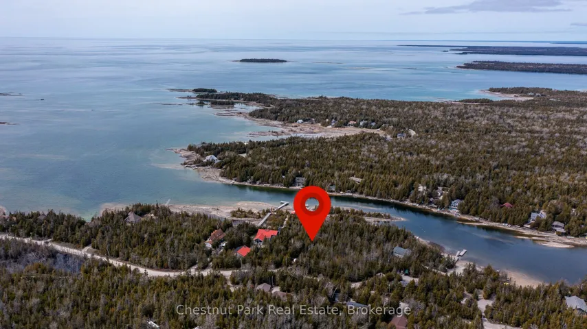
+"PublicRemarks": "Beautiful 1 ACRE waterfront property situated on the tip of the Bruce Peninsula. Located on sought-after Corey Crescent, surrounded by prestigious multi-million dollar shoreline estates. Lot 18 boasts a prime position on a sheltered deep-water channel in beautiful Hay Bay, ideal for building your own dock and safely mooring large vessels-a neighbouring property currently docks a boat over 30 feet in length. This generously sized lot stretches over 500 feet in depth with approximately 100 feet of waterfront, offering clear, swimmable waters and calm conditions for kayaking, canoeing, or paddleboarding right from your own backyard. The property showcases striking limestone outcrops and mature cedar trees, creating a peaceful and private setting that reflects the natural charm of the Bruce Peninsula. Situated on a quiet paved cul-de-sac, just minutes by car-or a pleasant bike, walk, or boat ride-from the lively Village of Tobermory. Enjoy easy access to local amenities including restaurants, shops, and renowned attractions like the Bruce Trail, Singing Sands, and the Grotto at Flowerpot Island. Secure your slice of paradise within the Fathom Five National Marine Park-an exceptional waterfront lot in a truly iconic location!"
+"CityRegion": "Northern Bruce Peninsula"
+"CountyOrParish": "Bruce"
+"CreationDate": "2025-11-04T12:51:06.932026+00:00"
+"CrossStreet": "Hay Bay Rd & Simpson Ave"
+"DirectionFaces": "West"
+"Directions": "Hwy 6 north, turn right on Hay Bay Road, road becomes Corey Crescent, Lot 18 is on right hand side between 74 & 80 Corey Crescent properties. Sign on property, enter driveway to right of sign to path through lot."
+"Disclosures": array:1 [
0 => "Other"
]
+"ExpirationDate": "2025-12-31"
+"InteriorFeatures": "None"
+"RFTransactionType": "For Sale"
+"InternetEntireListingDisplayYN": true
+"ListAOR": "One Point Association of REALTORS"
+"ListingContractDate": "2025-05-09"
+"LotSizeSource": "Geo Warehouse"
+"MainOfficeKey": "557200"
+"MajorChangeTimestamp": "2025-05-10T17:51:25Z"
+"MlsStatus": "New"
+"OccupantType": "Vacant"
+"OriginalEntryTimestamp": "2025-05-10T17:51:25Z"
+"OriginalListPrice": 399000.0
+"OriginatingSystemID": "A00001796"
+"OriginatingSystemKey": "Draft2370438"
+"ParcelNumber": "331030185"
+"ParkingFeatures": "Private"
+"ParkingTotal": "4.0"
+"PhotosChangeTimestamp": "2025-05-10T17:51:25Z"
+"PoolFeatures": "None"
+"Sewer": "None"
+"ShowingRequirements": array:1 [
0 => "Showing System"
]
+"SignOnPropertyYN": true
+"SourceSystemID": "A00001796"
+"SourceSystemName": "Toronto Regional Real Estate Board"
+"StateOrProvince": "ON"
+"StreetName": "Corey"
+"StreetNumber": "LT 18"
+"StreetSuffix": "Crescent"
+"TaxAnnualAmount": "1380.39"
+"TaxLegalDescription": "LT 18 PL 542 MUNICIPALITY OF NORTHERN BRUCE PENINSULA"
+"TaxYear": "2024"
+"Topography": array:2 [
0 => "Sloping"
1 => "Wooded/Treed"
]
+"TransactionBrokerCompensation": "2.5% + HST"
+"TransactionType": "For Sale"
+"View": array:2 [
0 => "Lake"
1 => "Trees/Woods"
]
+"WaterBodyName": "Lake Huron"
+"WaterfrontFeatures": "Waterfront-Deeded"
+"WaterfrontYN": true
+"Zoning": "R2-EH"
+"DDFYN": true
+"Water": "None"
+"GasYNA": "No"
+"CableYNA": "No"
+"LotDepth": 497.0
+"LotShape": "Irregular"
+"LotWidth": 98.0
+"SewerYNA": "No"
+"WaterYNA": "No"
+"@odata.id": "https://api.realtyfeed.com/reso/odata/Property('X12139678')"
+"Shoreline": array:3 [
0 => "Clean"
1 => "Rocky"
2 => "Natural"
]
+"WaterView": array:1 [
0 => "Direct"
]
+"RollNumber": "410968000401517"
+"SurveyType": "None"
+"Waterfront": array:1 [
0 => "Direct"
]
+"DockingType": array:1 [
0 => "None"
]
+"ElectricYNA": "No"
+"HoldoverDays": 90
+"TelephoneYNA": "No"
+"WaterBodyType": "Lake"
+"provider_name": "TRREB"
+"short_address": "Northern Bruce Peninsula, ON N0H 2R0, CA"
+"ContractStatus": "Available"
+"HSTApplication": array:1 [
0 => "Included In"
]
+"PossessionDate": "2025-06-16"
+"PossessionType": "Immediate"
+"PriorMlsStatus": "Draft"
+"LivingAreaRange": "< 700"
+"AccessToProperty": array:2 [
0 => "Paved Road"
1 => "Year Round Municipal Road"
]
+"AlternativePower": array:1 [
0 => "None"
]
+"LotSizeAreaUnits": "Acres"
+"PropertyFeatures": array:6 [
0 => "Cul de Sac/Dead End"
1 => "Lake Access"
2 => "Marina"
3 => "Rec./Commun.Centre"
4 => "School Bus Route"
5 => "Wooded/Treed"
]
+"SalesBrochureUrl": "https://pub.marq.com/LT18Corey Cres-brochure/"
+"LotIrregularities": "106' x 504' x 543' x 97"
+"LotSizeRangeAcres": ".50-1.99"
+"PossessionDetails": "TBN"
+"ShorelineExposure": "South West"
+"ShorelineAllowance": "Not Owned"
+"SpecialDesignation": array:1 [
0 => "Other"
]
+"ShowingAppointments": "Book Showings on Broker Bay or Call Office 705.445.5454."
+"WaterfrontAccessory": array:1 [
0 => "Not Applicable"
]
+"MediaChangeTimestamp": "2025-05-10T17:51:25Z"
+"SystemModificationTimestamp": "2025-10-21T23:18:44.717844Z"
+"PermissionToContactListingBrokerToAdvertise": true
+"Media": array:40 [
0 => array:26 [ …26]
1 => array:26 [ …26]
2 => array:26 [ …26]
3 => array:26 [ …26]
4 => array:26 [ …26]
5 => array:26 [ …26]
6 => array:26 [ …26]
7 => array:26 [ …26]
8 => array:26 [ …26]
9 => array:26 [ …26]
10 => array:26 [ …26]
11 => array:26 [ …26]
12 => array:26 [ …26]
13 => array:26 [ …26]
14 => array:26 [ …26]
15 => array:26 [ …26]
16 => array:26 [ …26]
17 => array:26 [ …26]
18 => array:26 [ …26]
19 => array:26 [ …26]
20 => array:26 [ …26]
21 => array:26 [ …26]
22 => array:26 [ …26]
23 => array:26 [ …26]
24 => array:26 [ …26]
25 => array:26 [ …26]
26 => array:26 [ …26]
27 => array:26 [ …26]
28 => array:26 [ …26]
29 => array:26 [ …26]
30 => array:26 [ …26]
31 => array:26 [ …26]
32 => array:26 [ …26]
33 => array:26 [ …26]
34 => array:26 [ …26]
35 => array:26 [ …26]
36 => array:26 [ …26]
37 => array:26 [ …26]
38 => array:26 [ …26]
39 => array:26 [ …26]
]
+"ID": "331908"
}
1 => Realtyna\MlsOnTheFly\Components\CloudPost\SubComponents\RFClient\SDK\RF\Entities\RFProperty {#14560
+post_id: "320848"
+post_author: 1
+"ListingKey": "E12127208"
+"ListingId": "E12127208"
+"PropertyType": "Residential"
+"PropertySubType": "Vacant Land"
+"StandardStatus": "Active"
+"ModificationTimestamp": "2025-09-23T02:25:04Z"
+"RFModificationTimestamp": "2025-11-04T15:54:52Z"
+"ListPrice": 2990000.0
+"BathroomsTotalInteger": 2.0
+"BathroomsHalf": 0
+"BedroomsTotal": 3.0
+"LotSizeArea": 0
+"LivingArea": 0
+"BuildingAreaTotal": 0
+"City": "Ajax"
+"PostalCode": "L1Z 1T4"
+"UnparsedAddress": "2405 Audley Road N, Ajax, ON L1Z 1T4"
+"Coordinates": array:2 [
0 => -79.014011
1 => 43.9099514
]
+"Latitude": 43.9099514
+"Longitude": -79.014011
+"YearBuilt": 0
+"InternetAddressDisplayYN": true
+"FeedTypes": "IDX"
+"ListOfficeName": "RE/MAX HALLMARK REALTY LTD."
+"OriginatingSystemName": "TRREB"
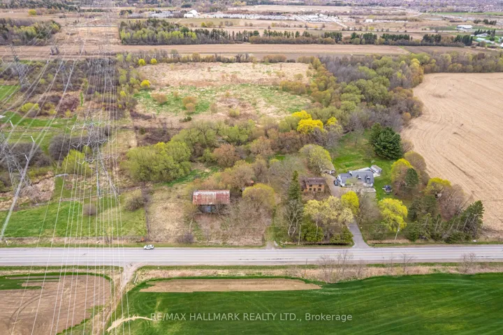
+"PublicRemarks": "Unlock potential with this expansive 20.88-acre property in prime Ajax situated across from the prestigious Deer Creek Golf Course and just minutes from Highways 401, 412, 407 & Hwy 7. This almost 21 acres of land includes the following structures: a century old house & barn, and detached garage all sold as-is-where-is. This is a rare opportunity set for developers seeking land in a well-established area, business owners envisioning a retreat, equestrian center, storage facility/ event space, urban farmers planning a farm-to-table operation/greenhouse business, or investors looking toward future residential or mixed-use development. Great location walking distance to public transit & minutes away from the Amazon Warehouse, shopping, restaurants, entertainment, Audley Centre, great schools & more. Whether you're imagining a private estate, a commercial venture, or a long-term land bank, this 20.88 acres of land and size offer endless possibilities."
+"ArchitecturalStyle": "2-Storey"
+"Basement": array:2 [
0 => "Full"
1 => "Unfinished"
]
+"CityRegion": "Northeast Ajax"
+"ConstructionMaterials": array:2 [
0 => "Wood"
1 => "Brick"
]
+"Cooling": "Central Air"
+"CoolingYN": true
+"Country": "CA"
+"CountyOrParish": "Durham"
+"CoveredSpaces": "2.0"
+"CreationDate": "2025-11-04T13:45:48.500266+00:00"
+"CrossStreet": "Salem /Taunton"
+"DirectionFaces": "East"
+"Directions": "HWY 407 and 412"
+"ExpirationDate": "2026-05-05"
+"FoundationDetails": array:1 [
0 => "Concrete Block"
]
+"GarageYN": true
+"HeatingYN": true
+"InteriorFeatures": "None"
+"RFTransactionType": "For Sale"
+"InternetEntireListingDisplayYN": true
+"ListAOR": "Toronto Regional Real Estate Board"
+"ListingContractDate": "2025-05-05"
+"LotDimensionsSource": "Other"
+"LotFeatures": array:1 [
0 => "Irregular Lot"
]
+"LotSizeDimensions": "313.62 x 889.53 Feet (20.88Ac Irreg.North:1404.72' Rear:993.21)"
+"LotSizeSource": "Other"
+"MainOfficeKey": "259000"
+"MajorChangeTimestamp": "2025-05-06T15:05:16Z"
+"MlsStatus": "New"
+"OccupantType": "Vacant"
+"OriginalEntryTimestamp": "2025-05-06T15:05:16Z"
+"OriginalListPrice": 2990000.0
+"OriginatingSystemID": "A00001796"
+"OriginatingSystemKey": "Draft2333256"
+"OtherStructures": array:2 [
0 => "Barn"
1 => "Paddocks"
]
+"ParkingFeatures": "Private"
+"ParkingTotal": "12.0"
+"PhotosChangeTimestamp": "2025-05-06T15:05:17Z"
+"PoolFeatures": "None"
+"Roof": "Asphalt Shingle"
+"RoomsTotal": "8"
+"Sewer": "Septic"
+"ShowingRequirements": array:1 [
0 => "List Brokerage"
]
+"SourceSystemID": "A00001796"
+"SourceSystemName": "Toronto Regional Real Estate Board"
+"StateOrProvince": "ON"
+"StreetDirSuffix": "N"
+"StreetName": "Audley"
+"StreetNumber": "2405"
+"StreetSuffix": "Road"
+"TaxAnnualAmount": "9374.0"
+"TaxLegalDescription": "Pt Lt 2 Con 4 Pickering Pt 1,40R6382; Town Of Ajax"
+"TaxYear": "2024"
+"TransactionBrokerCompensation": "2.5"
+"TransactionType": "For Sale"
+"VirtualTourURLUnbranded": "https://unbranded.mediatours.ca/property/2405-audley-road-ajax/"
+"Zoning": "EP, PC"
+"DDFYN": true
+"Water": "Well"
+"GasYNA": "Available"
+"CableYNA": "Yes"
+"HeatType": "Forced Air"
+"LotDepth": 1410.0
+"LotWidth": 313.62
+"SewerYNA": "No"
+"WaterYNA": "No"
+"@odata.id": "https://api.realtyfeed.com/reso/odata/Property('E12127208')"
+"PictureYN": true
+"GarageType": "Detached"
+"HeatSource": "Electric"
+"SurveyType": "Available"
+"Waterfront": array:1 [
0 => "None"
]
+"ElectricYNA": "Yes"
+"HoldoverDays": 90
+"TelephoneYNA": "Yes"
+"KitchensTotal": 1
+"ParkingSpaces": 10
+"provider_name": "TRREB"
+"short_address": "Ajax, ON L1Z 1T4, CA"
+"ContractStatus": "Available"
+"HSTApplication": array:1 [
0 => "Included In"
]
+"PossessionType": "30-59 days"
+"PriorMlsStatus": "Draft"
+"WashroomsType1": 1
+"WashroomsType2": 1
+"DenFamilyroomYN": true
+"LivingAreaRange": "< 700"
+"RoomsAboveGrade": 8
+"PropertyFeatures": array:6 [
0 => "Golf"
1 => "Library"
2 => "Public Transit"
3 => "Rec./Commun.Centre"
4 => "School"
5 => "Wooded/Treed"
]
+"StreetSuffixCode": "Rd"
+"BoardPropertyType": "Free"
+"LotIrregularities": "20.88Ac Irreg.North:1410.72' Rear:993.99"
+"LotSizeRangeAcres": "10-24.99"
+"PossessionDetails": "30-60 days"
+"WashroomsType1Pcs": 4
+"WashroomsType2Pcs": 3
+"BedroomsAboveGrade": 3
+"KitchensAboveGrade": 1
+"SpecialDesignation": array:1 [
0 => "Unknown"
]
+"MediaChangeTimestamp": "2025-05-06T15:05:17Z"
+"MLSAreaDistrictOldZone": "E14"
+"MLSAreaMunicipalityDistrict": "Ajax"
+"SystemModificationTimestamp": "2025-10-21T23:18:38.363597Z"
+"PermissionToContactListingBrokerToAdvertise": true
+"Media": array:46 [
0 => array:26 [ …26]
1 => array:26 [ …26]
2 => array:26 [ …26]
3 => array:26 [ …26]
4 => array:26 [ …26]
5 => array:26 [ …26]
6 => array:26 [ …26]
7 => array:26 [ …26]
8 => array:26 [ …26]
9 => array:26 [ …26]
10 => array:26 [ …26]
11 => array:26 [ …26]
12 => array:26 [ …26]
13 => array:26 [ …26]
14 => array:26 [ …26]
15 => array:26 [ …26]
16 => array:26 [ …26]
17 => array:26 [ …26]
18 => array:26 [ …26]
19 => array:26 [ …26]
20 => array:26 [ …26]
21 => array:26 [ …26]
22 => array:26 [ …26]
23 => array:26 [ …26]
24 => array:26 [ …26]
25 => array:26 [ …26]
26 => array:26 [ …26]
27 => array:26 [ …26]
28 => array:26 [ …26]
29 => array:26 [ …26]
30 => array:26 [ …26]
31 => array:26 [ …26]
32 => array:26 [ …26]
33 => array:26 [ …26]
34 => array:26 [ …26]
35 => array:26 [ …26]
36 => array:26 [ …26]
37 => array:26 [ …26]
38 => array:26 [ …26]
39 => array:26 [ …26]
40 => array:26 [ …26]
41 => array:26 [ …26]
42 => array:26 [ …26]
43 => array:26 [ …26]
44 => array:26 [ …26]
45 => array:26 [ …26]
]
+"ID": "320848"
}
2 => Realtyna\MlsOnTheFly\Components\CloudPost\SubComponents\RFClient\SDK\RF\Entities\RFProperty {#14557
+post_id: "534054"
+post_author: 1
+"ListingKey": "X12419617"
+"ListingId": "X12419617"
+"PropertyType": "Residential"
+"PropertySubType": "Vacant Land"
+"StandardStatus": "Active"
+"ModificationTimestamp": "2025-09-22T19:05:40Z"
+"RFModificationTimestamp": "2025-11-12T15:07:16Z"
+"ListPrice": 995000.0
+"BathroomsTotalInteger": 0
+"BathroomsHalf": 0
+"BedroomsTotal": 0
+"LotSizeArea": 4.24
+"LivingArea": 0
+"BuildingAreaTotal": 0
+"City": "Prince Edward County"
+"PostalCode": "K0K 2T0"
+"UnparsedAddress": "1448 County Road 12 Road, Prince Edward County, ON K0K 2T0"
+"Coordinates": array:2 [
0 => -77.1520291
1 => 43.9984996
]
+"Latitude": 43.9984996
+"Longitude": -77.1520291
+"YearBuilt": 0
+"InternetAddressDisplayYN": true
+"FeedTypes": "IDX"
+"ListOfficeName": "CENTURY 21 LANTHORN REAL ESTATE LTD."
+"OriginatingSystemName": "TRREB"
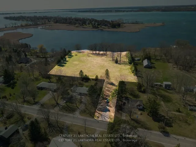
+"PublicRemarks": "Welcome to your paradise at 1448 County Road 12! Whether you envision a lakeside retreat, cottage escape or a luxury waterfront estate, this 4.24 acre waterfront property has a well on-site and is a blank canvas awaiting your personal touch. Nestled along the shores of West Lake, this oasis offers an idyllic setting for relaxing and enjoying nature surrounded by birdsong. Boasting views of the Dunes at Sandbanks Provincial Park, close to renowned wineries and the vibrant town of Picton, you'll have easy access to recreational and cultural amenities alike.The County's Shore Land designation offers the possibility of recreational development which makes this an incredibly rare opportunity in one of Prince Edward County's most coveted locations. Experience the ultimate waterfront lifestyle, where every day feels like a vacation. **EXTRAS** Dredged boat slip allows access to the lake."
+"CityRegion": "Hallowell Ward"
+"CoListOfficeName": "CENTURY 21 LANTHORN REAL ESTATE LTD."
+"CoListOfficePhone": "613-967-2100"
+"Country": "CA"
+"CountyOrParish": "Prince Edward County"
+"CreationDate": "2025-11-04T14:05:56.298679+00:00"
+"CrossStreet": "Ridge Rd/ County Rd 12"
+"DirectionFaces": "West"
+"Directions": "CR 12"
+"Disclosures": array:1 [
0 => "Conservation Regulations"
]
+"ExpirationDate": "2026-09-22"
+"RFTransactionType": "For Sale"
+"InternetEntireListingDisplayYN": true
+"ListAOR": "Central Lakes Association of REALTORS"
+"ListingContractDate": "2025-09-22"
+"LotSizeSource": "MPAC"
+"MainOfficeKey": "437200"
+"MajorChangeTimestamp": "2025-09-22T19:05:40Z"
+"MlsStatus": "New"
+"OccupantType": "Vacant"
+"OriginalEntryTimestamp": "2025-09-22T19:05:40Z"
+"OriginalListPrice": 995000.0
+"OriginatingSystemID": "A00001796"
+"OriginatingSystemKey": "Draft3031640"
+"ParcelNumber": "550510658"
+"PhotosChangeTimestamp": "2025-09-22T19:05:40Z"
+"ShowingRequirements": array:1 [
0 => "Showing System"
]
+"SignOnPropertyYN": true
+"SourceSystemID": "A00001796"
+"SourceSystemName": "Toronto Regional Real Estate Board"
+"StateOrProvince": "ON"
+"StreetName": "County Road 12"
+"StreetNumber": "1448"
+"StreetSuffix": "Road"
+"TaxAnnualAmount": "4548.0"
+"TaxLegalDescription": "LT 68 RCP 27 HALLOWELL EXCEPT PART 1 PLAN 47R9241, S/T & T/W PE102240; S/T HW15082; PRINCE EDWARD"
+"TaxYear": "2024"
+"TransactionBrokerCompensation": "2.5% +HST"
+"TransactionType": "For Sale"
+"WaterBodyName": "West Lake"
+"WaterfrontFeatures": "Boat Slip,Waterfront-Deeded"
+"WaterfrontYN": true
+"Zoning": "RR2"
+"DDFYN": true
+"GasYNA": "Available"
+"CableYNA": "Available"
+"LotDepth": 485.0
+"LotShape": "Irregular"
+"LotWidth": 57.0
+"SewerYNA": "No"
+"WaterYNA": "No"
+"@odata.id": "https://api.realtyfeed.com/reso/odata/Property('X12419617')"
+"Shoreline": array:1 [
0 => "Weedy"
]
+"WaterView": array:1 [
0 => "Direct"
]
+"WellDepth": 11.2
+"RollNumber": "135051102006400"
+"SurveyType": "Available"
+"Waterfront": array:1 [
0 => "Direct"
]
+"DockingType": array:1 [
0 => "None"
]
+"ElectricYNA": "Available"
+"HoldoverDays": 60
+"TelephoneYNA": "Available"
+"WellCapacity": 8.0
+"WaterBodyType": "Lake"
+"provider_name": "TRREB"
+"short_address": "Prince Edward County, ON K0K 2T0, CA"
+"AssessmentYear": 2025
+"ContractStatus": "Available"
+"HSTApplication": array:1 [
0 => "In Addition To"
]
+"PossessionType": "Immediate"
+"PriorMlsStatus": "Draft"
+"WaterFrontageFt": "121.92"
+"AccessToProperty": array:2 [
0 => "Paved Road"
1 => "Year Round Municipal Road"
]
+"AlternativePower": array:1 [
0 => "None"
]
+"LotSizeAreaUnits": "Acres"
+"LotSizeRangeAcres": "2-4.99"
+"PossessionDetails": "Immediate"
+"ShorelineExposure": "West"
+"ShorelineAllowance": "Owned"
+"SpecialDesignation": array:1 [
0 => "Unknown"
]
+"WaterfrontAccessory": array:1 [
0 => "Not Applicable"
]
+"MediaChangeTimestamp": "2025-09-22T19:05:40Z"
+"SystemModificationTimestamp": "2025-10-21T23:40:34.656792Z"
+"PermissionToContactListingBrokerToAdvertise": true
+"Media": array:20 [
0 => array:26 [ …26]
1 => array:26 [ …26]
2 => array:26 [ …26]
3 => array:26 [ …26]
4 => array:26 [ …26]
5 => array:26 [ …26]
6 => array:26 [ …26]
7 => array:26 [ …26]
8 => array:26 [ …26]
9 => array:26 [ …26]
10 => array:26 [ …26]
11 => array:26 [ …26]
12 => array:26 [ …26]
13 => array:26 [ …26]
14 => array:26 [ …26]
15 => array:26 [ …26]
16 => array:26 [ …26]
17 => array:26 [ …26]
18 => array:26 [ …26]
19 => array:26 [ …26]
]
+"ID": "534054"
}
3 => Realtyna\MlsOnTheFly\Components\CloudPost\SubComponents\RFClient\SDK\RF\Entities\RFProperty {#14552
+post_id: "622162"
+post_author: 1
+"ListingKey": "X12506642"
+"ListingId": "X12506642"
+"PropertyType": "Residential"
+"PropertySubType": "Vacant Land"
+"StandardStatus": "Active"
+"ModificationTimestamp": "2025-11-05T14:45:11Z"
+"RFModificationTimestamp": "2025-11-13T08:14:51Z"
+"ListPrice": 130000.0
+"BathroomsTotalInteger": 0
+"BathroomsHalf": 0
+"BedroomsTotal": 0
+"LotSizeArea": 16.0
+"LivingArea": 0
+"BuildingAreaTotal": 0
+"City": "Whitestone"
+"PostalCode": "P0A 1G0"
+"UnparsedAddress": "1025 520n Highway, Whitestone, ON P0A 1G0"
+"Coordinates": array:2 [
0 => -80.0555538
1 => 45.6857252
]
+"Latitude": 45.6857252
+"Longitude": -80.0555538
+"YearBuilt": 0
+"InternetAddressDisplayYN": true
+"FeedTypes": "IDX"
+"ListOfficeName": "RE/MAX Parry Sound Muskoka Realty Ltd"
+"OriginatingSystemName": "TRREB"
+"PublicRemarks": "Nature Lover's Paradise - 16 Acres of Untouched Beauty Welcome to your private escape! This remarkable 16-acre property offers the ultimate retreat for outdoor enthusiasts. Explore a landscape defined by its pond/marsh that becomes a snowy playground in winter-perfect for snowmobiling directly onto provincial trails or taking a scenic route to friends on Wahwashkesh Lake. A gently winding trail makes it easy to stroll through the property, revealing multiple ideal building sites for your future cabin, cottage, or retreat. With hydro available at the highway and an entrance permit already in place, much of the groundwork is complete. Rich in biodiversity, the land features eight species of trees and abundant wildlife-offering a peaceful connection to nature in every season. Launch a canoe or kayak across the marsh to access even more acreage, your own hidden private sanctuary on the far side. Whether your dream is to build, relax, or simply immerse yourself in the quiet beauty of Northern Ontario, this rare offering invites you to breathe deeply, explore freely, and reconnect with nature. Zoned RU, the property allows for a variety of potential uses. Don't miss the video-rumour has it Bigfoot makes a cameo!"
+"CityRegion": "Whitestone"
+"CountyOrParish": "Parry Sound"
+"CreationDate": "2025-11-04T14:28:57.963905+00:00"
+"CrossStreet": "HWY 520N and Ainslie Lake Rd"
+"DirectionFaces": "South"
+"Directions": "HWY 124 to HWY 520N"
+"ExpirationDate": "2026-02-28"
+"RFTransactionType": "For Sale"
+"InternetEntireListingDisplayYN": true
+"ListAOR": "One Point Association of REALTORS"
+"ListingContractDate": "2025-11-04"
+"LotSizeSource": "MPAC"
+"MainOfficeKey": "547700"
+"MajorChangeTimestamp": "2025-11-04T14:24:44Z"
+"MlsStatus": "New"
+"OccupantType": "Vacant"
+"OriginalEntryTimestamp": "2025-11-04T14:24:44Z"
+"OriginalListPrice": 130000.0
+"OriginatingSystemID": "A00001796"
+"OriginatingSystemKey": "Draft3211890"
+"ParcelNumber": "522500718"
+"PhotosChangeTimestamp": "2025-11-04T14:24:44Z"
+"ShowingRequirements": array:2 [
0 => "Go Direct"
1 => "Showing System"
]
+"SignOnPropertyYN": true
+"SourceSystemID": "A00001796"
+"SourceSystemName": "Toronto Regional Real Estate Board"
+"StateOrProvince": "ON"
+"StreetName": "520N"
+"StreetNumber": "1025"
+"StreetSuffix": "Highway"
+"TaxAnnualAmount": "357.81"
+"TaxLegalDescription": "PART LOT 23 CONCESSION 3, MCKENZIE, PART 1, 42R22178 MUNICIPALITY OF WHITESTONE"
+"TaxYear": "2025"
+"TransactionBrokerCompensation": "2.5%"
+"TransactionType": "For Sale"
+"VirtualTourURLUnbranded": "https://www.youtube.com/watch?v=-UJxn CMy HSs"
+"VirtualTourURLUnbranded2": "https://www.youtube.com/watch?v=-UJxn CMy HSs"
+"Zoning": "RU"
+"DDFYN": true
+"GasYNA": "No"
+"CableYNA": "Available"
+"LotDepth": 1338.0
+"LotShape": "Irregular"
+"LotWidth": 548.0
+"SewerYNA": "No"
+"WaterYNA": "No"
+"@odata.id": "https://api.realtyfeed.com/reso/odata/Property('X12506642')"
+"SurveyType": "Available"
+"Waterfront": array:1 [
0 => "None"
]
+"ElectricYNA": "Available"
+"HoldoverDays": 90
+"TelephoneYNA": "Available"
+"provider_name": "TRREB"
+"ContractStatus": "Available"
+"HSTApplication": array:1 [
0 => "Not Subject to HST"
]
+"PossessionType": "Flexible"
+"PriorMlsStatus": "Draft"
+"LotSizeAreaUnits": "Acres"
+"LotSizeRangeAcres": "10-24.99"
+"PossessionDetails": "Flexible"
+"SpecialDesignation": array:1 [
0 => "Unknown"
]
+"MediaChangeTimestamp": "2025-11-04T14:24:44Z"
+"SystemModificationTimestamp": "2025-11-05T14:45:11.780255Z"
+"PermissionToContactListingBrokerToAdvertise": true
+"Media": array:14 [
0 => array:26 [ …26]
1 => array:26 [ …26]
2 => array:26 [ …26]
3 => array:26 [ …26]
4 => array:26 [ …26]
5 => array:26 [ …26]
6 => array:26 [ …26]
…7
]
+"ID": "622162"
}
4 => Realtyna\MlsOnTheFly\Components\CloudPost\SubComponents\RFClient\SDK\RF\Entities\RFProperty {#14551
+post_id: "471041"
+post_author: 1
+"ListingKey": "X12327688"
+"ListingId": "X12327688"
+"PropertyType": "Residential"
+"PropertySubType": "Vacant Land"
+"StandardStatus": "Active"
+"ModificationTimestamp": "2025-09-21T03:34:26Z"
+"RFModificationTimestamp": "2025-11-04T15:58:50Z"
+"ListPrice": 650000.0
+"BathroomsTotalInteger": 1.0
+"BathroomsHalf": 0
+"BedroomsTotal": 2.0
+"LotSizeArea": 205.3
+"LivingArea": 0
+"BuildingAreaTotal": 0
+"City": "West Nipissing"
+"PostalCode": "P0H 1M0"
+"UnparsedAddress": "191 Ashburton Road, West Nipissing, ON P0H 1M0"
+"Coordinates": array:2 [ …2]
+"Latitude": 46.5084287
+"Longitude": -79.9912284
+"YearBuilt": 0
+"InternetAddressDisplayYN": true
+"FeedTypes": "IDX"
+"ListOfficeName": "RIGHT AT HOME REALTY"
+"OriginatingSystemName": "TRREB"
+"PublicRemarks": "This 205-acre off-grid parcel of land is situated between the Pike River on the north and the Sturgeon River on the south, with approximately 11,000 feet of river frontage. It contains two seasonal dwellings, the first being a trailer with a built-on summer kitchen and great room, all under a steel roof. One owner uses this in winter by means of a propane-powered generator. Lights are run from solar panels and water is pumped from the Pike River. A roomy two-room cabin is situated deeper into the property, past a 20-acre field. A third seasonal dwelling, a trailer (not included), is located on the Sturgeon River, where there is a cleared area and a dock. The current owners have used this property for hunting, fishing, gardening, swimming and family get-togethers. One historical use was as a farm. The soil is a rich loam, mostly free of stones. Land could be cleared and re-purposed for self-sustained homesteading. There is a natural spring on the property which could be developed into a water source. There is a small beach on the Pike River. Another possible use would be as a recreational campground. An ATV and OFSC trail currently runs east-west through the property on an old railbed, making it easy to access most of the land and the village of Field, where Riverview Market stocks essential groceries with an LCBO outlet. Smokey's River Shack offers poutine, fries and hamburgers. Field offers a post office, library, fire hall, Caisse Alliance, Notre-dame-des-Victoires church, a covered hockey arena and a friendly community."
+"AccessibilityFeatures": array:1 [ …1]
+"ArchitecturalStyle": "1 Storey/Apt"
+"Basement": array:1 [ …1]
+"CityRegion": "Field"
+"ConstructionMaterials": array:2 [ …2]
+"CountyOrParish": "Nipissing"
+"CreationDate": "2025-11-04T14:55:50.334614+00:00"
+"CrossStreet": "LAROCQUE STREET AND ASHBURTON ROAD"
+"DirectionFaces": "West"
+"Directions": "HWY 64 AND LAROCQUE ST., EAST TO ASHBURTON"
+"Disclosures": array:1 [ …1]
+"Exclusions": "Two lamps in common room of the trailer dwelling; large china cabinet in seasonal cabin, one travel trailer next to Sturgeon River."
+"ExpirationDate": "2026-08-04"
+"ExteriorFeatures": "Seasonal Living"
+"FoundationDetails": array:1 [ …1]
+"Inclusions": "One seasonal (used in winter) trailer and one seasonal cabin"
+"InteriorFeatures": "Generator - Partial"
+"RFTransactionType": "For Sale"
+"InternetEntireListingDisplayYN": true
+"ListAOR": "Toronto Regional Real Estate Board"
+"ListingContractDate": "2025-08-05"
+"LotSizeSource": "MPAC"
+"MainOfficeKey": "062200"
+"MajorChangeTimestamp": "2025-08-06T16:39:33Z"
+"MlsStatus": "New"
+"OccupantType": "Owner"
+"OriginalEntryTimestamp": "2025-08-06T16:39:33Z"
+"OriginalListPrice": 650000.0
+"OriginatingSystemID": "A00001796"
+"OriginatingSystemKey": "Draft2800878"
+"OtherStructures": array:3 [ …3]
+"ParcelNumber": "490720080"
+"ParkingFeatures": "Lane"
+"ParkingTotal": "6.0"
+"PhotosChangeTimestamp": "2025-09-23T14:08:38Z"
+"PoolFeatures": "None"
+"Roof": "Metal"
+"Sewer": "Other"
+"ShowingRequirements": array:1 [ …1]
+"SignOnPropertyYN": true
+"SoilType": array:1 [ …1]
+"SourceSystemID": "A00001796"
+"SourceSystemName": "Toronto Regional Real Estate Board"
+"StateOrProvince": "ON"
+"StreetName": "Ashburton"
+"StreetNumber": "191"
+"StreetSuffix": "Road"
+"TaxAnnualAmount": "1881.11"
+"TaxLegalDescription": "CON 4&5 PT LOT 11 PCL 13088 NIP CON 4 PT LOT 12 CON 5 PT LOTS 12&13 REM PCL 11995 NIP"
+"TaxYear": "2025"
+"Topography": array:4 [ …4]
+"TransactionBrokerCompensation": "2.5"
+"TransactionType": "For Sale"
+"View": array:2 [ …2]
+"WaterBodyName": "Sturgeon River"
+"WaterSource": array:1 [ …1]
+"WaterfrontFeatures": "Dock"
+"WaterfrontYN": true
+"Zoning": "RU"
+"UFFI": "No"
+"DDFYN": true
+"Water": "Other"
+"GasYNA": "No"
+"Sewage": array:1 [ …1]
+"CableYNA": "No"
+"LotShape": "Irregular"
+"LotWidth": 5129.11
+"SewerYNA": "No"
+"WaterYNA": "No"
+"@odata.id": "https://api.realtyfeed.com/reso/odata/Property('X12327688')"
+"Shoreline": array:2 [ …2]
+"WaterView": array:1 [ …1]
+"RollNumber": "485207000229000"
+"SurveyType": "None"
+"Waterfront": array:1 [ …1]
+"ChannelName": "Pike River"
+"DockingType": array:1 [ …1]
+"ElectricYNA": "No"
+"FarmFeatures": array:1 [ …1]
+"HoldoverDays": 90
+"TelephoneYNA": "No"
+"KitchensTotal": 2
+"ParcelNumber2": 490720081
+"ParkingSpaces": 4
+"UnderContract": array:1 [ …1]
+"WaterBodyType": "River"
+"provider_name": "TRREB"
+"short_address": "West Nipissing, ON P0H 1M0, CA"
+"ApproximateAge": "16-30"
+"ContractStatus": "Available"
+"HSTApplication": array:1 [ …1]
+"PossessionType": "Flexible"
+"PriorMlsStatus": "Draft"
+"RuralUtilities": array:2 [ …2]
+"WashroomsType1": 1
+"LivingAreaRange": "700-1100"
+"RoomsAboveGrade": 6
+"WaterFrontageFt": "1500"
+"AccessToProperty": array:1 [ …1]
+"AlternativePower": array:1 [ …1]
+"LotSizeAreaUnits": "Acres"
+"ParcelOfTiedLand": "No"
+"PropertyFeatures": array:4 [ …4]
+"SeasonalDwelling": true
+"LotIrregularities": "IRREGULAR"
+"LotSizeRangeAcres": "100 +"
+"PossessionDetails": "30 days"
+"ShorelineExposure": "South"
+"WashroomsType1Pcs": 3
+"BedroomsAboveGrade": 2
+"KitchensAboveGrade": 2
+"ShorelineAllowance": "None"
+"SpecialDesignation": array:1 [ …1]
+"LeaseToOwnEquipment": array:1 [ …1]
+"WashroomsType1Level": "Ground"
+"WaterfrontAccessory": array:1 [ …1]
+"MediaChangeTimestamp": "2025-09-23T14:08:38Z"
+"DevelopmentChargesPaid": array:1 [ …1]
+"SystemModificationTimestamp": "2025-10-21T23:25:57.636246Z"
+"Media": array:31 [ …31]
+"ID": "471041"
}
5 => Realtyna\MlsOnTheFly\Components\CloudPost\SubComponents\RFClient\SDK\RF\Entities\RFProperty {#14559
+post_id: "620340"
+post_author: 1
+"ListingKey": "X12507488"
+"ListingId": "X12507488"
+"PropertyType": "Residential"
+"PropertySubType": "Vacant Land"
+"StandardStatus": "Active"
+"ModificationTimestamp": "2025-11-12T17:40:15Z"
+"RFModificationTimestamp": "2025-11-12T18:04:13Z"
+"ListPrice": 2000000.0
+"BathroomsTotalInteger": 0
+"BathroomsHalf": 0
+"BedroomsTotal": 0
+"LotSizeArea": 0
+"LivingArea": 0
+"BuildingAreaTotal": 0
+"City": "Kawartha Lakes"
+"PostalCode": "L0K 1W0"
+"UnparsedAddress": "26-28 Chisholm Trail, Kawartha Lakes, ON L0K 1W0"
+"Coordinates": array:2 [ …2]
+"Latitude": 44.7766582
+"Longitude": -79.1656736
+"YearBuilt": 0
+"InternetAddressDisplayYN": true
+"FeedTypes": "IDX"
+"ListOfficeName": "HOMELIFE LANDMARK REALTY INC."
+"OriginatingSystemName": "TRREB"
+"PublicRemarks": "You Are Welcome To See This Great Investment Opportunity In Sebright Ontario - 26 -28 Chisholm Trail Sebright Kawartha Lakes, ON L0K1W0 With 600.63 Acres Of Land (26,163,768.67 ft) , 90 Minutes Away From Toronto. The Property Is Privately Owned And Is Described As Wilderness Area With Features Like Wooded Areas, Ponds, Muskoka Rocks. Current Property Zoning Is Rural General Zone & EP Zone With Many Permitted Uses. Please See The Attached Zoning Report. Seller Also Willing To Give VTB (SELLER FINANCING MORTGAGE) For Most Qualified Buyer With Low Down Payments As 20% Of The Purchase Price For 5-10 Years Term Subject To Buyer's Qualifications"
+"CityRegion": "Dalton"
+"CountyOrParish": "Kawartha Lakes"
+"CreationDate": "2025-11-04T16:00:50.113400+00:00"
+"CrossStreet": "Black River Road & Chisholm Trail"
+"DirectionFaces": "East"
+"Directions": "From Orillia ON HWY 6 TO Black River Road UNTIL Chisholm Trail"
+"Exclusions": "None"
+"ExpirationDate": "2026-11-30"
+"Inclusions": "None"
+"RFTransactionType": "For Sale"
+"InternetEntireListingDisplayYN": true
+"ListAOR": "Toronto Regional Real Estate Board"
+"ListingContractDate": "2025-11-04"
+"MainOfficeKey": "063000"
+"MajorChangeTimestamp": "2025-11-04T15:50:37Z"
+"MlsStatus": "New"
+"OccupantType": "Vacant"
+"OriginalEntryTimestamp": "2025-11-04T15:50:37Z"
+"OriginalListPrice": 2000000.0
+"OriginatingSystemID": "A00001796"
+"OriginatingSystemKey": "Draft3210906"
+"ParcelNumber": "631060143"
+"PhotosChangeTimestamp": "2025-11-04T15:50:38Z"
+"ShowingRequirements": array:1 [ …1]
+"SourceSystemID": "A00001796"
+"SourceSystemName": "Toronto Regional Real Estate Board"
+"StateOrProvince": "ON"
+"StreetName": "Chisholm"
+"StreetNumber": "26-28"
+"StreetSuffix": "Trail"
+"TaxAnnualAmount": "975.7"
+"TaxLegalDescription": "LT 26-28 CON 10 DALTON; LT 26-28 CON 11 DALTON CITY OF KAWARTHA LAKES"
+"TaxYear": "2024"
+"TransactionBrokerCompensation": "2.50% +HST"
+"TransactionType": "For Sale"
+"VirtualTourURLUnbranded": "https://photos.app.goo.gl/GE8ENq XQ1Rnr ZZSE9"
+"VirtualTourURLUnbranded2": "https://photos.app.goo.gl/GE8ENq XQ1Rnr ZZSE9"
+"Zoning": "Rural General Zone (RG)"
+"DDFYN": true
+"GasYNA": "No"
+"CableYNA": "No"
+"LotDepth": 6605.44
+"LotWidth": 3962.56
+"SewerYNA": "No"
+"WaterYNA": "No"
+"@odata.id": "https://api.realtyfeed.com/reso/odata/Property('X12507488')"
+"RollNumber": "165103900217800"
+"SurveyType": "None"
+"Waterfront": array:1 [ …1]
+"ElectricYNA": "No"
+"HoldoverDays": 90
+"TelephoneYNA": "No"
+"provider_name": "TRREB"
+"ContractStatus": "Available"
+"HSTApplication": array:1 [ …1]
+"PossessionType": "Flexible"
+"PriorMlsStatus": "Draft"
+"LotSizeRangeAcres": "100 +"
+"PossessionDetails": "TBA"
+"SpecialDesignation": array:1 [ …1]
+"MediaChangeTimestamp": "2025-11-04T15:50:38Z"
+"SystemModificationTimestamp": "2025-11-12T17:40:15.275462Z"
+"PermissionToContactListingBrokerToAdvertise": true
+"Media": array:5 [ …5]
+"ID": "620340"
}
6 => Realtyna\MlsOnTheFly\Components\CloudPost\SubComponents\RFClient\SDK\RF\Entities\RFProperty {#14389
+post_id: "613009"
+post_author: 1
+"ListingKey": "E12485462"
+"ListingId": "E12485462"
+"PropertyType": "Residential"
+"PropertySubType": "Vacant Land"
+"StandardStatus": "Active"
+"ModificationTimestamp": "2025-11-03T18:04:33Z"
+"RFModificationTimestamp": "2025-11-13T08:10:46Z"
+"ListPrice": 1590000.0
+"BathroomsTotalInteger": 0
+"BathroomsHalf": 0
+"BedroomsTotal": 0
+"LotSizeArea": 0
+"LivingArea": 0
+"BuildingAreaTotal": 0
+"City": "Whitby"
+"PostalCode": "L1R 2W1"
+"UnparsedAddress": "4560 Anderson St Street, Whitby, ON L1R 2W1"
+"Coordinates": array:2 [ …2]
+"Latitude": 43.9316795
+"Longitude": -78.9428782
+"YearBuilt": 0
+"InternetAddressDisplayYN": true
+"FeedTypes": "IDX"
+"ListOfficeName": "ROYAL LEPAGE RCR REALTY"
+"OriginatingSystemName": "TRREB"
+"PublicRemarks": "Escape to your own private 12-acre woodland retreat! Imagine designing your dream estate on this secluded, partially cleared lot, perfectly nestled in a mature forest steps to all amenities. Enter through the majestic gates into your own kingdom. This property is the ideal setting for those who crave privacy, peace, luxury and nature without sacrificing convenience. Enjoy the best of both worlds: the tranquility of the countryside with all the benefits of city proximity. Located in a highly-desired area, you're just moments from top schools, shopping, and amenities. For commuters, it's a dream location, offering immediate access to Highways 401 and 407 for an easy 30-minute trip to Toronto. This lot is ready for your vision and the permitting process, offering flexible servicing options including potential municipal sewer connection or a private septic system (buyer to verify all details).This is a rare opportunity to create your legacy. $100,000 in improvements since last purchased getting it ready for you."
+"CityRegion": "Taunton North"
+"CoListOfficeName": "ROYAL LEPAGE RCR REALTY"
+"CoListOfficePhone": "905-836-1212"
+"Country": "CA"
+"CountyOrParish": "Durham"
+"CreationDate": "2025-11-04T16:42:01.823225+00:00"
+"CrossStreet": "Taunton Rd E /Anderson St"
+"DirectionFaces": "West"
+"Directions": "Anderson St North of Taunton Rd"
+"ExpirationDate": "2026-06-30"
+"RFTransactionType": "For Sale"
+"InternetEntireListingDisplayYN": true
+"ListAOR": "Toronto Regional Real Estate Board"
+"ListingContractDate": "2025-10-27"
+"MainOfficeKey": "074500"
+"MajorChangeTimestamp": "2025-10-28T14:36:36Z"
+"MlsStatus": "New"
+"OccupantType": "Vacant"
+"OriginalEntryTimestamp": "2025-10-28T14:36:36Z"
+"OriginalListPrice": 1590000.0
+"OriginatingSystemID": "A00001796"
+"OriginatingSystemKey": "Draft3171086"
+"PhotosChangeTimestamp": "2025-10-28T14:36:37Z"
+"ShowingRequirements": array:1 [ …1]
+"SignOnPropertyYN": true
+"SourceSystemID": "A00001796"
+"SourceSystemName": "Toronto Regional Real Estate Board"
+"StateOrProvince": "ON"
+"StreetName": "Anderson St"
+"StreetNumber": "4560"
+"StreetSuffix": "Street"
+"TaxAnnualAmount": "8192.8"
+"TaxLegalDescription": "PT LT 23 CON 4 TOWNSHIP OF WHITBY,PT LT 24 CON 4AS IN C0142624"
+"TaxYear": "2025"
+"TransactionBrokerCompensation": "2.5% +HST"
+"TransactionType": "For Sale"
+"VirtualTourURLUnbranded": "http://www.mcspropertyshowcase.ca/index.cfm?id=5141552"
+"DDFYN": true
+"GasYNA": "No"
+"CableYNA": "No"
+"LotDepth": 1989.63
+"LotWidth": 262.99
+"SewerYNA": "No"
+"WaterYNA": "No"
+"@odata.id": "https://api.realtyfeed.com/reso/odata/Property('E12485462')"
+"SurveyType": "Available"
+"Waterfront": array:1 [ …1]
+"ElectricYNA": "No"
+"HoldoverDays": 90
+"TelephoneYNA": "No"
+"provider_name": "TRREB"
+"short_address": "Whitby, ON L1R 2W1, CA"
+"ContractStatus": "Available"
+"HSTApplication": array:1 [ …1]
+"PossessionType": "Immediate"
+"PriorMlsStatus": "Draft"
+"CoListOfficeName3": "ROYAL LEPAGE RCR REALTY"
+"LotSizeRangeAcres": "10-24.99"
+"PossessionDetails": "TBD"
+"SpecialDesignation": array:1 [ …1]
+"MediaChangeTimestamp": "2025-10-28T14:36:37Z"
+"SystemModificationTimestamp": "2025-11-03T18:04:33.145057Z"
+"PermissionToContactListingBrokerToAdvertise": true
+"Media": array:50 [ …50]
+"ID": "613009"
}
7 => Realtyna\MlsOnTheFly\Components\CloudPost\SubComponents\RFClient\SDK\RF\Entities\RFProperty {#14553
+post_id: "622131"
+post_author: 1
+"ListingKey": "X12507824"
+"ListingId": "X12507824"
+"PropertyType": "Residential"
+"PropertySubType": "Vacant Land"
+"StandardStatus": "Active"
+"ModificationTimestamp": "2025-11-05T15:06:49Z"
+"RFModificationTimestamp": "2025-11-08T02:35:42Z"
+"ListPrice": 850000.0
+"BathroomsTotalInteger": 0
+"BathroomsHalf": 0
+"BedroomsTotal": 0
+"LotSizeArea": 100.6
+"LivingArea": 0
+"BuildingAreaTotal": 0
+"City": "Algonquin Highlands"
+"PostalCode": "K0M 1S0"
+"UnparsedAddress": "1134 Walkers Line Road, Algonquin Highlands, ON K0M 1S0"
+"Coordinates": array:2 [ …2]
+"Latitude": 45.2946735
+"Longitude": -78.8255515
+"YearBuilt": 0
+"InternetAddressDisplayYN": true
+"FeedTypes": "IDX"
+"ListOfficeName": "RE/MAX Professionals North"
+"OriginatingSystemName": "TRREB"
+"PublicRemarks": "A special piece of property! This 100-acre parcel offers privacy, a stunning forest consisting of mature oak, pine and maple, and your own private frontage on serene, spring-fed Coulter Lake. Only one other property owner on the lake plus Crown Land. A driveway takes you right to the dock! This is the perfect getaway for the fisherman or naturalist. Build your dream home or retreat and sit back and relax. The location of this acreage is also a bonus. The boat launch for beautiful Kushog Lake is moments away, and several more lakes surround the area, including Halls Lake, Boshkung Lake, St. Nora, and so many more. Close to the Algonquin Water Trails system for extensive canoeing, kayaking, snowshoe and cross-country ski trails. Coulter Lake was stocked with small and large mouth Bass six years ago and is ready for your line! This truly is a property that needs to be seen, come check it out!"
+"CityRegion": "Stanhope"
+"CoListOfficeName": "RE/MAX Professionals North"
+"CoListOfficePhone": "705-286-2911"
+"CountyOrParish": "Haliburton"
+"CreationDate": "2025-11-04T16:54:47.242699+00:00"
+"CrossStreet": "Buckslide Rd/Walkers Line"
+"DirectionFaces": "North"
+"Directions": "Hwy 35 to Buckslide Rd, then Walkers line"
+"Disclosures": array:1 [ …1]
+"ExpirationDate": "2026-05-31"
+"Inclusions": "Dock"
+"RFTransactionType": "For Sale"
+"InternetEntireListingDisplayYN": true
+"ListAOR": "One Point Association of REALTORS"
+"ListingContractDate": "2025-11-04"
+"LotSizeSource": "Geo Warehouse"
+"MainOfficeKey": "549100"
+"MajorChangeTimestamp": "2025-11-04T16:29:02Z"
+"MlsStatus": "New"
+"OccupantType": "Vacant"
+"OriginalEntryTimestamp": "2025-11-04T16:29:02Z"
+"OriginalListPrice": 850000.0
+"OriginatingSystemID": "A00001796"
+"OriginatingSystemKey": "Draft3219418"
+"ParcelNumber": "393030253"
+"PhotosChangeTimestamp": "2025-11-05T15:06:49Z"
+"ShowingRequirements": array:1 [ …1]
+"SourceSystemID": "A00001796"
+"SourceSystemName": "Toronto Regional Real Estate Board"
+"StateOrProvince": "ON"
+"StreetName": "Walkers Line"
+"StreetNumber": "1134"
+"StreetSuffix": "Road"
+"TaxAnnualAmount": "546.49"
+"TaxLegalDescription": "LT 6 CON 5 STANHOPE; ALGONQUIN HIGHLANDS"
+"TaxYear": "2024"
+"TransactionBrokerCompensation": "2.5"
+"TransactionType": "For Sale"
+"WaterBodyName": "Coulter Lake"
+"WaterfrontFeatures": "Not Applicable"
+"WaterfrontYN": true
+"Zoning": "RU"
+"DDFYN": true
+"GasYNA": "No"
+"CableYNA": "No"
+"LotDepth": 3314.0
+"LotShape": "Rectangular"
+"LotWidth": 1322.0
+"SewerYNA": "No"
+"WaterYNA": "No"
+"@odata.id": "https://api.realtyfeed.com/reso/odata/Property('X12507824')"
+"Shoreline": array:1 [ …1]
+"WaterView": array:1 [ …1]
+"RollNumber": "462100200042400"
+"SurveyType": "None"
+"Waterfront": array:1 [ …1]
+"DockingType": array:1 [ …1]
+"ElectricYNA": "Available"
+"HoldoverDays": 60
+"TelephoneYNA": "Available"
+"WaterBodyType": "Lake"
+"provider_name": "TRREB"
+"ContractStatus": "Available"
+"HSTApplication": array:1 [ …1]
+"PossessionType": "Flexible"
+"PriorMlsStatus": "Draft"
+"AccessToProperty": array:1 [ …1]
+"AlternativePower": array:1 [ …1]
+"LotSizeAreaUnits": "Acres"
+"LotSizeRangeAcres": "100 +"
+"PossessionDetails": "Flexible"
+"ShorelineAllowance": "None"
+"SpecialDesignation": array:1 [ …1]
+"WaterfrontAccessory": array:1 [ …1]
+"MediaChangeTimestamp": "2025-11-05T15:06:49Z"
+"SystemModificationTimestamp": "2025-11-05T15:06:49.799829Z"
+"Media": array:21 [ …21]
+"ID": "622131"
}
8 => Realtyna\MlsOnTheFly\Components\CloudPost\SubComponents\RFClient\SDK\RF\Entities\RFProperty {#14554
+post_id: "453845"
+post_author: 1
+"ListingKey": "X12289187"
+"ListingId": "X12289187"
+"PropertyType": "Residential"
+"PropertySubType": "Vacant Land"
+"StandardStatus": "Active"
+"ModificationTimestamp": "2025-11-10T19:05:58Z"
+"RFModificationTimestamp": "2025-11-13T08:13:08Z"
+"ListPrice": 49900.0
+"BathroomsTotalInteger": 0
+"BathroomsHalf": 0
+"BedroomsTotal": 0
+"LotSizeArea": 0
+"LivingArea": 0
+"BuildingAreaTotal": 0
+"City": "Cockburn Island"
+"PostalCode": "P0P 1R0"
+"UnparsedAddress": "25 I Street, Cockburn Island, ON P0P 1R0"
+"Coordinates": array:2 [ …2]
+"Latitude": 45.9223748
+"Longitude": -83.3797872
+"YearBuilt": 0
+"InternetAddressDisplayYN": true
+"FeedTypes": "IDX"
+"ListOfficeName": "Royal Le Page RCR Realty"
+"OriginatingSystemName": "TRREB"
+"PublicRemarks": "Cockburn Island - located off the western tip of Manitoulin Island. Unique opportunity to purchase a 1 acre lot that is truly an escape from the ordinary. Ranked one of the Top 10 islands for its conservation importance, lack of disturbance and biodiversity. With over 90% of the island protected and maintained by the Nature Conservancy of Canada there are only a handful of opportunities to purchase and create a retreat where you can enjoy natural beaches, untouched forests, vast conservation land, hiking and wildlife. This property is walking distance to the main island dock. Although an ideal off-grid situation, there is hydro available at the road. 3 season access by boat from public docks or private plane. Drummond Island, USA is directly west of Cockburn Island. Go direct no appointment required. DIRECTIONS: from Meldrum Bay on Manitoulin Island, by boat to Tolsmaville, Cockburn Island. From the main dock, south on Sideroad 10 to I street. East to the lot on the north west corner (where the road bends). For further information about the island go to cockburnisland.ca"
+"CoListOfficeName": "Royal Le Page RCR Realty"
+"CoListOfficePhone": "519-924-2950"
+"CountyOrParish": "Manitoulin"
+"CreationDate": "2025-11-04T17:52:28.792013+00:00"
+"CrossStreet": "Side Road 10 and I Street"
+"DirectionFaces": "North"
+"Directions": "E Off Side Rd 10 on I Street to lot on NW corner"
+"ExpirationDate": "2026-01-14"
+"RFTransactionType": "For Sale"
+"InternetEntireListingDisplayYN": true
+"ListAOR": "One Point Association of REALTORS"
+"ListingContractDate": "2025-07-16"
+"LotSizeSource": "Geo Warehouse"
+"MainOfficeKey": "571600"
+"MajorChangeTimestamp": "2025-07-16T18:51:17Z"
+"MlsStatus": "New"
+"OccupantType": "Vacant"
+"OriginalEntryTimestamp": "2025-07-16T18:51:17Z"
+"OriginalListPrice": 49900.0
+"OriginatingSystemID": "A00001796"
+"OriginatingSystemKey": "Draft2703144"
+"ParcelNumber": "471000427"
+"PhotosChangeTimestamp": "2025-07-16T18:51:17Z"
+"ShowingRequirements": array:1 [ …1]
+"SourceSystemID": "A00001796"
+"SourceSystemName": "Toronto Regional Real Estate Board"
+"StateOrProvince": "ON"
+"StreetName": "I"
+"StreetNumber": "25"
+"StreetSuffix": "Street"
+"TaxAnnualAmount": "300.82"
+"TaxAssessedValue": 22500
+"TaxLegalDescription": "Lot 25 N/S I St Plan 8; Township of Cockburn Island, District of Manitoulin"
+"TaxYear": "2025"
+"TransactionBrokerCompensation": "2.5% +hst"
+"TransactionType": "For Sale"
+"Zoning": "Rural"
+"DDFYN": true
+"GasYNA": "No"
+"CableYNA": "No"
+"LotDepth": 264.0
+"LotShape": "Rectangular"
+"LotWidth": 165.0
+"SewerYNA": "No"
+"WaterYNA": "No"
+"@odata.id": "https://api.realtyfeed.com/reso/odata/Property('X12289187')"
+"RollNumber": "513400000505901"
+"SurveyType": "None"
+"Waterfront": array:1 [ …1]
+"ElectricYNA": "Available"
+"TelephoneYNA": "No"
+"provider_name": "TRREB"
+"AssessmentYear": 2025
+"ContractStatus": "Available"
+"HSTApplication": array:1 [ …1]
+"PossessionType": "Immediate"
+"PriorMlsStatus": "Draft"
+"PropertyFeatures": array:2 [ …2]
+"LotSizeRangeAcres": ".50-1.99"
+"PossessionDetails": "Immediate"
+"SpecialDesignation": array:1 [ …1]
+"ShowingAppointments": "Vacant land go direct"
+"MediaChangeTimestamp": "2025-07-16T18:51:17Z"
+"SystemModificationTimestamp": "2025-11-10T19:05:58.151833Z"
+"Media": array:16 [ …16]
+"ID": "453845"
}
9 => Realtyna\MlsOnTheFly\Components\CloudPost\SubComponents\RFClient\SDK\RF\Entities\RFProperty {#14556
+post_id: "442554"
+post_author: 1
+"ListingKey": "X12279971"
+"ListingId": "X12279971"
+"PropertyType": "Residential"
+"PropertySubType": "Vacant Land"
+"StandardStatus": "Active"
+"ModificationTimestamp": "2025-11-10T18:49:16Z"
+"RFModificationTimestamp": "2025-11-10T19:17:42Z"
+"ListPrice": 249900.0
+"BathroomsTotalInteger": 0
+"BathroomsHalf": 0
+"BedroomsTotal": 0
+"LotSizeArea": 0
+"LivingArea": 0
+"BuildingAreaTotal": 0
+"City": "Kincardine"
+"PostalCode": "N0G 2T0"
+"UnparsedAddress": "Lot 2, Kincardine, ON N0G 2T0"
+"Coordinates": array:2 [ …2]
+"Latitude": 44.1776378
+"Longitude": -81.6348713
+"YearBuilt": 0
+"InternetAddressDisplayYN": true
+"FeedTypes": "IDX"
+"ListOfficeName": "Royal Le Page Exchange Realty Co."
+"OriginatingSystemName": "TRREB"
+"PublicRemarks": "Nestled in a serene natural setting, this 3-acre treed lot offers the perfect blend of privacy and location. Situated just minutes from Inverhuron and Inverhuron Provincial Park, and ideally positioned between Kincardine and Port Elgin, it provides easy access to Lake Huron, local amenities, and Bruce Power. Whether you're dreaming of building a year-round home or a peaceful retreat, this property presents a fantastic opportunity. Buyer to complete their own due diligence regarding building and development potential."
+"CountyOrParish": "Bruce"
+"CreationDate": "2025-11-04T17:53:38.174886+00:00"
+"CrossStreet": "Albert Road & Concession Rd 2"
+"DirectionFaces": "West"
+"Directions": "Heading West on Bruce Road 15 towards Inverhuron, turn right onto Albert Road, property is on the West side of the road prior to Concession 2"
+"ExpirationDate": "2026-01-09"
+"RFTransactionType": "For Sale"
+"InternetEntireListingDisplayYN": true
+"ListAOR": "One Point Association of REALTORS"
+"ListingContractDate": "2025-07-11"
+"LotSizeSource": "Geo Warehouse"
+"MainOfficeKey": "572600"
+"MajorChangeTimestamp": "2025-07-11T19:26:31Z"
+"MlsStatus": "New"
+"OccupantType": "Vacant"
+"OriginalEntryTimestamp": "2025-07-11T19:26:31Z"
+"OriginalListPrice": 249900.0
+"OriginatingSystemID": "A00001796"
+"OriginatingSystemKey": "Draft2651612"
+"PhotosChangeTimestamp": "2025-07-11T19:26:31Z"
+"ShowingRequirements": array:1 [ …1]
+"SourceSystemID": "A00001796"
+"SourceSystemName": "Toronto Regional Real Estate Board"
+"StateOrProvince": "ON"
+"StreetName": "Albert"
+"StreetNumber": "Lot 2, 3, 4"
+"StreetSuffix": "Road"
+"TaxLegalDescription": "LT 2 W/S ALBERT ST, 3 W/S ALBERT ST, 4 W/S ALBERT ST PL INVERHURON; KINCARDINE"
+"TaxYear": "2024"
+"TransactionBrokerCompensation": "2.0% + HST"
+"TransactionType": "For Sale"
+"View": array:2 [ …2]
+"DDFYN": true
+"GasYNA": "No"
+"CableYNA": "Available"
+"LotDepth": 330.0
+"LotWidth": 396.0
+"SewerYNA": "No"
+"WaterYNA": "No"
+"@odata.id": "https://api.realtyfeed.com/reso/odata/Property('X12279971')"
+"SurveyType": "None"
+"Waterfront": array:1 [ …1]
+"ElectricYNA": "Available"
+"TelephoneYNA": "Available"
+"provider_name": "TRREB"
+"ContractStatus": "Available"
+"HSTApplication": array:1 [ …1]
+"PossessionDate": "2025-08-04"
+"PossessionType": "Immediate"
+"PriorMlsStatus": "Draft"
+"PropertyFeatures": array:5 [ …5]
+"LotSizeRangeAcres": "2-4.99"
+"PossessionDetails": "Immediate"
+"SpecialDesignation": array:1 [ …1]
+"MediaChangeTimestamp": "2025-07-15T18:31:49Z"
+"DevelopmentChargesPaid": array:1 [ …1]
+"SystemModificationTimestamp": "2025-11-10T18:49:16.667721Z"
+"PermissionToContactListingBrokerToAdvertise": true
+"Media": array:1 [ …1]
+"ID": "442554"
}
]
+success: true
+page_size: 10
+page_count: 350
+count: 3492
+after_key: ""
}
"RF Response Time" => "0.26 seconds"
]
]